Poultney
2. Lower (US Route 4 to Carvers Falls Dam)
Mar 26, 2022
I was included in an email conversation this week about an incident that occurred on the lower Poultney on Saturday, March 19. A landowner behaved in a threatening manner (involving a firearm) towards two boaters who were running the stretch. One of them, Jake Roberts, subsequently replied in that conversation (on March 24) with the following account of what happened:
'I was with the group that had the altercation. We were hiking laps of the first rapid on the lower Poultney below the water line. The land owner of what we believe to be 32 Golf Course Road on the New York side got our attention by firing a shot that seemed to be in our direction. After looking around for a moment he fired another round and when we saw him it looked as though he was aiming his weapon in our direction. I quickly ran down the rapid and everyone else got in their boats and we paddled away. He followed us a short way down the river continuing to wave his gun around yelling at us. After the run I called the state police dispatcher in the area at this number: 518-747-4623. I filed a report and spoke to an officer who followed up with the land owner. I have not heard anything back from them but I do plan to follow up with the police again when I get the opportunity.'
Oct 9, 2011
Right on-this helped me sort tihngs right out.
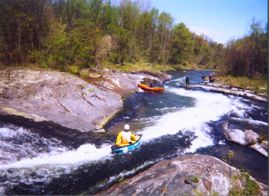
Sep 7, 2011
We went to the Poultney today, 9/7/11 @ 750~ish CFS. Awesome time! No wood in the rapids. The only noticeable differences were:
1. The fence behind the Visitor's Center along the river came down, making for a much easier seal-launch.
2. The banks are eroded a bit, but did not change the main features of the river.
3. There are some trees down in the flat in-between parts.
4. There is a strainer after the last rapid where the river divides in two from a large sand bar. The right channel is COMPLETELY blocked by a river-wide strainer. After the last rapid, just make sure you hit the left channel.
5. The most problematic part of the flooding is probably finding a good spot to get out. The normal portage where the signs are before the dam is very hard to get out from because all of the sediments and clay are new and washed over the banks. We couldn't even walk through it, I sank in to my knees and had to pull my boat right up to me so that I could lay on it and wiggle my leg back out. Don't try to walk through that stuff unless you want to get stuck or sink in muddy clay. We just paddled further down, right up to the RIVER LEFT side of the dam (be careful, the river gets narrow and if you go too far right you'll go over the dam) where the little dam control building is and clambered our way over the bank which is also covered in the same mucky clay. There was a tree that we used to avoid stepping in the muck. Try to spend as little time there as you can, as it's technically trespassing. You can walk to the parking lot by following the chain link fence.
May 29, 2007
There is a strainer above the --Slide-- as of 5/20/07
May 2, 2005
Some nice fairly easy drops, a few rapids and a bit of flat. Not really to pushy. Went like this.
We stared the run near the VT Welcome Center with an otter slide in! This of course was after we crossed a non barbed fence that was partly fixed on a bank that had broken away in recent spring flow. A few yards of flat brings you under the road past a dead beaver on river left and to the first drop. Pretty straight forward line is visible just left of center but to be safe we were ready with ropes. It's a steep grade but not really ledgey, Can be seen from Rt.4
Next I recall a few flat yards downstream was a really interesting slide. The flow was lower than we expected and most of the water was heading straight down a mildly steep grade in a lazy s. A fair sized eddy was available if you stay far left on the slide. If you cross it with a planning hull you'll skip like a rock lol. However most of us (three of four) stayed center and the end of the slide was somewhat rough shallow and definitely fast. A larger flow would have given you the option to go right, down two other steeper slides into what would probably be holes at the base.
If I remember correctly next were a couple decent short class II rapids. Then the 'waterfall' a pretty ledgy drop into a pool with a big back current in the center and most of river left side. We ran it on the right landing between river right shore line and a big boulder that sat just to the right of center left of paddler lol. Now directly after this drop is a narrow slide that is split by a rock Island. At the end of the island on the left route is a big sticky hole that seemed fairly easy for James and Pete to get around on the far left in their creekers. To run it on river right of the island you must paddle hard at the fork up a swollen shoulder of water, a funny current that 'fakes right and goes left'! If you make it over that it's cake and you are home free. Don't flip there cause it's somewhat shallow on the slide over a boulder.
I may have forgotten one or two somewhat inconsequential rapids or small ledges but for the most part that sums it up. The end is a quarter mile or so of flat slow moving water surrounded by steep clay bare banks. We did see one fat live beaver and four deer crossing the river, no they weren't together lol... Plus a pair of Canada geese. I think all together twas a fun run. Could have been more of a challenge at higher flow. The AW guage seemed way off so it seemed lower than we expected. As far as access goes we didn't have to portage anything and I really didn't see any dwellings too close to the banks so I imagine you're fine. I did notice some no trespass signs here and there.
~todd