Poultney
2. Lower (US Route 4 to Carvers Falls Dam)
| Difficulty | III-IV |
| Length | 3.9 mi |
| Avg Gradient | n/a |
| Gauge | Poultney River Below Fair Haven, Vt |
| Flow Rate as of 1 hour | 46 cfsbelow recommended |
| Reach Info Last Updated | April 30, 2018 |
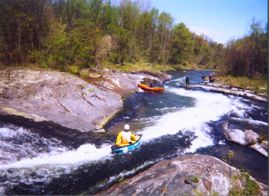
This baby forms part of the Vermont / New York border near the South end of Lake Champlain.
Posted on the VPC message board by Faith Knapp
On a very fine day in May, a group of us decided to go to the Poultney River and run the section from Fair Haven to Carver Falls Dam. Faith, Nancy and John had a wonderful time running this river last June and had great memories of the trip. Only trouble is, John loved telling the stories, and every time he described the slide (which is quite long) it got longer! Well, this time he came armed with his daughter's video camera to prove to those doubting Thomases that such a slide does exist.
We put in near the Vermont Welcome Center and off we went. Just under the Route 4 bridge and about 75 feet downstream, we all got out on the left, careful to stay below the high water mark, to scout the first rapid. Landowners in the area have had some pretty unpleasant experiences with boaters in the past.
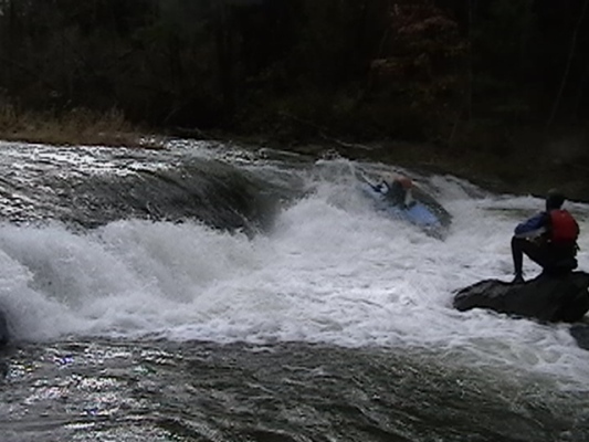
A considerable drop with a few rocks showing their faces was our intro the the river. John had his camera ready and got some good movies.
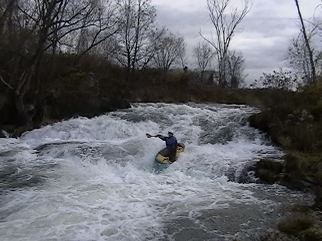
The second drop was the memorable 'slide'. Only one way down and we all felt that as we reached the bottom we were doing 90 MPH. A couple of us caught the eddy on river (no...slide) left. Others went all the way to the end, and a few perched atop a couple of rocks on slide right. This area could have some incredible dynamics at higher levels with the ledge and rock formations that are there. Some carried up for repeat performances. A short run and strong party permitted more play time -- and several of the drops were run repeatedly.
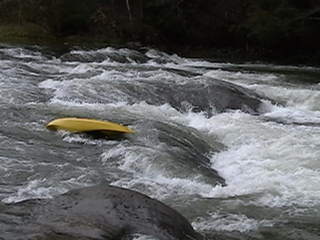
There are about 8 ledge drops with play areas in this 4 1/2 mi. stretch. We found an island and enjoyed a leisurely lunch in the sun. Soon we came upon the waterfall that does not look particularly nice. Last year Faith & Eric had an interesting swim. Nancy described it as a washing machine seeing arms and legs going i
...Put in at the Vermont Welcome Center in Fairhaven, VT. From the front of the Welcome Center head left towards a field. Go down the hill to the water. Be careful of the old barbed wire fence. Seal launch in and head downstream. Beware landowners are not friendly to boaters so try to stay off their land.
After you pass under the Rt. 4 Bridge you will encounter your first rapid. You will see a horizon line and a small old cement building on river right. To scout, eddy out above the drop on river left. This rapid is very rocky. The best line is river left of center. At the bottom there is a small hole that can stop your speed.
Before you get to the slide you have some flat water and ripples to go through. You will know that you are approaching the slide when you see a giant railroad bridge. This can be another access point as well. (I can't remember the road name but if you jump back on Rt. 4 towards New York you will pass over a bridge (the first drop) and turn right onto the first road you see; go down until you pass railroad tracks. Park along the road and hike on the tracks (be careful). Cross the bridge and make your way down to the water via an old path on the right hand side.) To scout the slide, eddy out on river right under the bridge. Walk along the rocks in the center until you see the slide. To run this rapid, head out of the eddy, and paddle straight down stream. You will reach the slide and head down. As soon as you are off the slide there is an eddy on river left with, a strong eddy wall. If you keep heading down stream follow the white water. The river makes a J shape after the slide. The rapid ends with a shallow hole that likes to flip people and scuff up their helmets. After the hole, eddy out river left to run safety or watch your buddies.
The next three miles are full of small ledges and small surf spots. The first small rapid you will encounter is right under a bridge. There is usually a small hole you can play in here. After you are done playing the river makes another J turn with some small rapids in it. After this rapid there is another small drop that you can scout on river right if you want. The last time I ran this rapid it was low and shallow. Make your way downstream, enjoying Vermont's countryside.
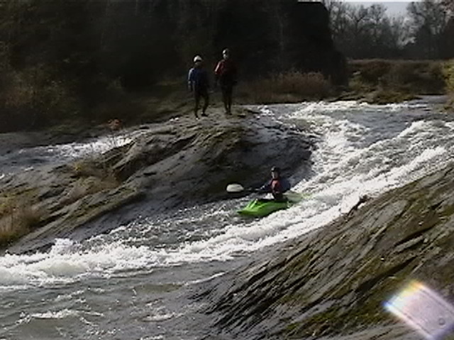
When you see a horizon line, eddy out on river right. Scout the rapid and choose your line. I choose left of center but I have heard of people running right of center and it not being a pleasant experience. After this first section there is a small pool to recover before the end of the rapid.
You ended up in flat water after the first drop of this rapid from here the river makes a right hand turn. Follow the main flow right into a hole. I recommend scouting the hole and possible setting up safety. It's not the nicest looking hole and last time I ran it I got munched twice before I paddled out. If you want to avoid this either walk around on river right or take a small shallow chute over to river-right before the hole.
You end up in flat water after the first drop of this rapid. From here the river makes a righthand turn. Follow the main flow right into a hole. I recommend scouting the hole and possible setting up safety. It's not the nicest looking hole and last time I ran it I got munched twice before I paddled out. If you want to avoid this either walk around on river-right or take a small shallow chute over to river-right before the hole.
After the last rapid, paddle along the flat water until you see signs for the Carver Falls Dam and a trail on river left. Follow the trail to your car. For directions to the take-out, look up the dam on Google or wait for a update from me so I can get the road names.
Mar 26, 2022
I was included in an email conversation this week about an incident that occurred on the lower Poultney on Saturday, March 19. A landowner behaved in a threatening manner (involving a firearm) towards two boaters who were running the stretch. One of them, Jake Roberts, subsequently replied in that conversation (on March 24) with the following account of what happened:
'I was with the group that had the altercation. We were hiking laps of the first rapid on the lower Poultney below the water line. The land owner of what we believe to be 32 Golf Course Road on the New York side got our attention by firing a shot that seemed to be in our direction. After looking around for a moment he fired another round and when we saw him it looked as though he was aiming his weapon in our direction. I quickly ran down the rapid and everyone else got in their boats and we paddled away. He followed us a short way down the river continuing to wave his gun around yelling at us. After the run I called the state police dispatcher in the area at this number: 518-747-4623. I filed a report and spoke to an officer who followed up with the land owner. I have not heard anything back from them but I do plan to follow up with the police again when I get the opportunity.'
Oct 9, 2011
Right on-this helped me sort tihngs right out.
