Bower Creek
Fonferek Falls to Hwy.V/Tordeur Ct.(4.3 miles)
| Difficulty | II-III(IV) |
| Length | 4.4 mi |
| Avg Gradient | 40 fpm |
| Gauge | Dutchman Creek at Hansen Rd at Ashwaubenon, Wi |
| Flow Rate as of 38 minutes | 3 cfsbelow recommended |
| Reach Info Last Updated | March 3, 2025 |
Quick Facts:
Location: Approximately 9 miles SE from downtown Green Bay, WI.
Shuttle Length: 3.3 miles.
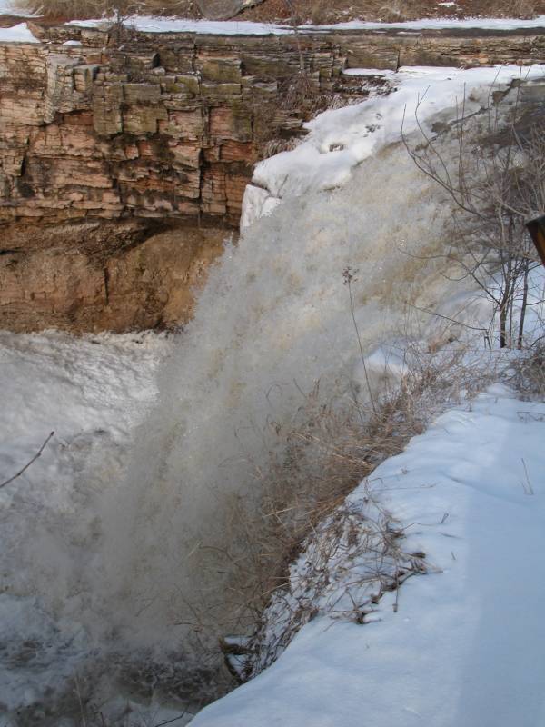
Character: Small creek with bedrock river-bed. A sheer vertical waterfall drops into a grotto. The creek caroms down sloping bedrock for the next mile or so.
Drainage area at put-in: approximately 14.8 square miles.
Put-in is approximately 767' elevation.
Take-out is approximately 597' elevation.
Thus total elevation change is approximately 170'.
Nearby ('companion') runs (with drainages, for comparison): Baird Creek (15.7 sq.mi.), School Creek (15 sq.mi.), Devil's River (36 sq.mi.), Neshota/West Twin (43 sq.mi.).
General Overview
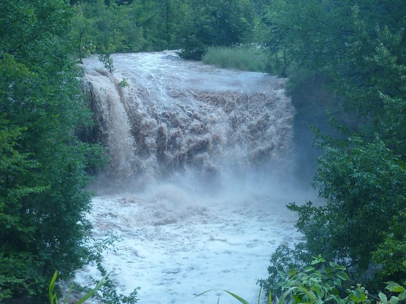
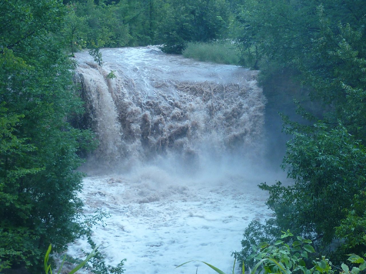
This little creek boasts an impressive (for EastCentral Wisconsin), scenic, ~20' waterfall, followed by a scenic dells section. That said, you'll be so busy with an assortment of sloping bedrock slides, and scattered quarry-like rubble which litter the rapids, along with the fact that there will be precious few eddies in this first stretch, so it's doubtful you'll have much time to admire the scenery.
This is NOT recommended for anyone in a 'recreational kayak', and is NOT recommended for anyone without considerable whitewater skills and experience. This creek is narrow, with high banks, tight/blind curves, quite continuous action (especially in the early going), and has areas which are routinely completely blocked by deadfall. There is precious little margin for error. If you can't catch a 'one boat eddy' (or if you have no idea what that even means), then you should not ev
...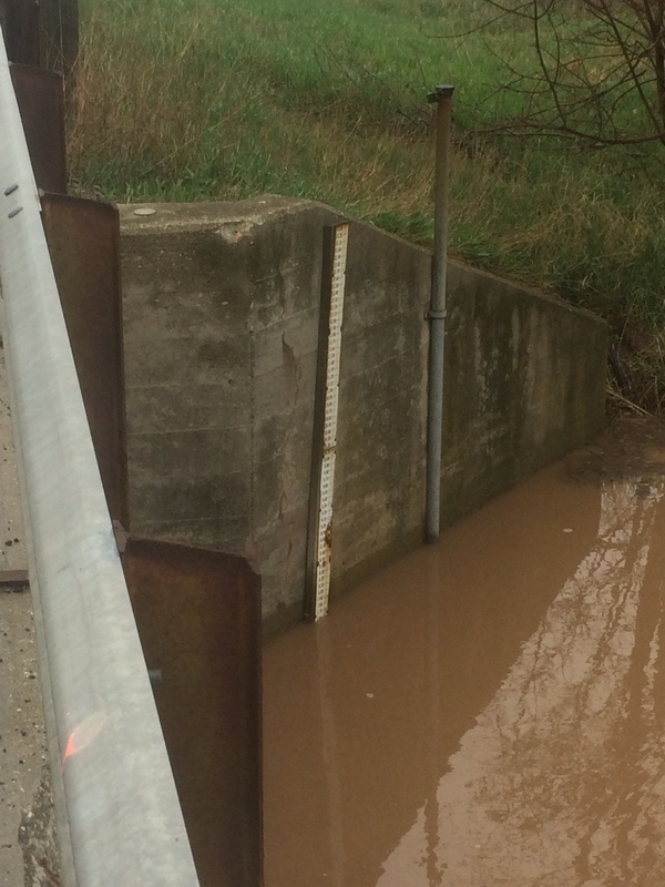
A USGS gauge at CTH.MM (14.8 square miles drainage) was deactivated years ago. There remains a staff gauge which can (should) be read for actual level of this run.

From the gauge down to our recommended put-in (below Fonferek Falls) this creek traverses a bedrock streambed. There are places which (at boatable flows) develop some very sweet-looking waves. However, with Fonfereck Falls just downstream, only the most experienced, skilled, and daring of boaters will entertain any thoughts of testing them out for play.
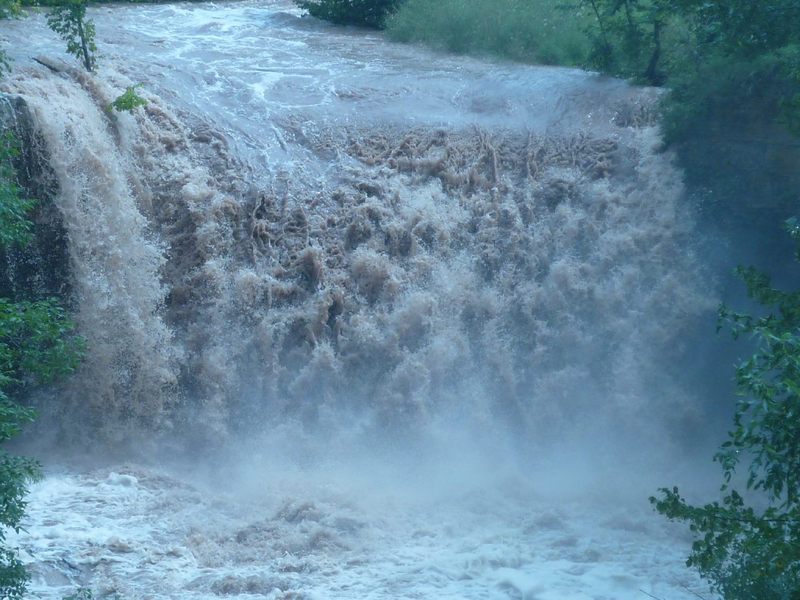
Yes, this has been run ... multiple laps, even. However, be aware the landing pool is VERY shallow virtually everywhere, never more than 2-3' deep! Launch and land a solid 'boof', or expect sprained or broken ankles and boat damage!
From the parking area for Fonferek Falls County Park, you'll walk between a barn and a shed (keeping clear of the private residence which shares the driveway to the parking area), then head to your right (to the East) to the creek.
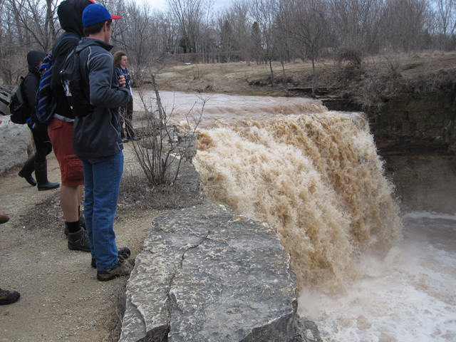
Most boaters will be content to view Fonferek Falls (from various vantage points) then carry downstream (to the left) rather than risk broken ankles and damaged boats.
There is a steep narrow muddy/rocky path to stream level. Either find a spot for seal launch into a rip-snorting start, or walk your boat upstream (minimal shoreline, so mostly in-water, rivers-edge) for a put-in as far towards the pool at the base of the falls as you can, to stage for the run downstream.
More experienced boaters who are confident in launching and landing a successful 'boof' will carry upstream (to the right). We strongly advise having a person (with throw rope) staged in the aforementioned pool for safety for anyone who opts to run the falls. Again, that whole pool area is almost uniformly knee-to-thigh-deep, so the safety person can walk and 'stage' themselves almost anywhere in that pool.
At the lowest boatable flows, this opening sequence may be a bang-and-thump-grunge (whereas most of the rest of the run may go fine).
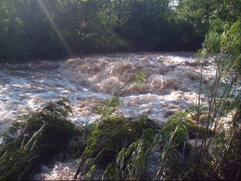
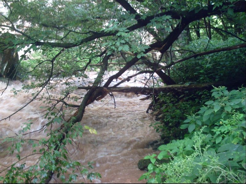
However, with anything above minimal flows, this will be a freight-train rush with very few eddies for the first 0.25-0.5 mile!
For that reason it is very strongly recommended to scout the entire opening sequence (0.25 - 0.5 mile) before putting in.
Any fallen tree or branch can easily block this creek shore-to-shore and it may be nearly impossible to avoid disaster!
From the recommended put-in (below Fonferek Falls), the river slides down sloping bedrock, forming numerous small waves. As you head toward a cliff/wall ahead of you, you'll encounter a steeper slide into a small ledge. Overhead at this location, there is a 'skylight' -- a hole in the overhanging (high overhead) cliff wall. At some flows, this could get 'sticky'. At some flows, there may be some play possible here, since there is a bit of a pool and eddies. However, the creek takes a sharp turn to the right so the outflow does head strongly toward the wall, meaning that if you flip, you had better roll quickly or you'll be against the wall, and flushing out of the pool into the next sequence of gradient.
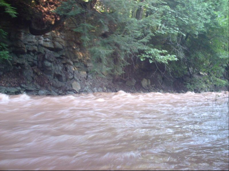
Just downstream of Skylight Ledge (where the creek did about a 90-degree right-turn), you'll head toward a blind, 90-degree left-turn. The water will accelerate down a fine set of rips through a bit of a dells area.
At low flows, this will be rather shallow. The streambed is littered with slab rock, meaning anyone upside-down or out of their boat will likely be punished and pummeled severely. There are (no doubt) plenty of spots where foot-entrapment is a possibility (for anyone who tries to stand in the stream).
At moderate-to-high flows, there will be strong current leading into this bend, and even stronger as soon as you round the bend. There will be no eddies, and no reasonable way to exit the river. This area has been prone to having overhanging branches or over-arching trees, and can have wood hung up on shore and rocks. For this reason, it is virtually mandatory to hike down to this point (before putting on) to scout this whole area to be sure of safe passage.
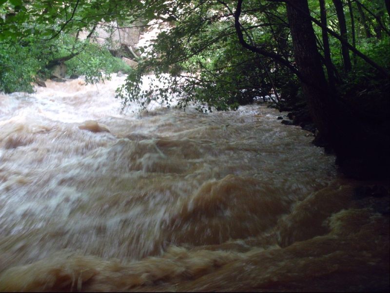
Just after leaving the county park (there are signs on the river banks indicating you are entering private property), the creek encounters an area of braided channel and massive deadfall which blocks almost all downstream paths. Proceed with maximum caution, especially at higher flows.
(Location is approximate, as creek is obscured, and I'm uncertain about how far down feature is.)
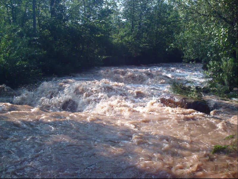
After a good straightaway and clearing, just as the creek heads into more wooded banks, a large erratic boulder lies to the side, and back-to-back waves will be encountered. At low-to-moderate flows, they may not be too noteworthy, but at high flow, there is some meat here!
It is possible to shorten the trip by taking-out at the end of Mayline Road, which dead-ends near the creek on river right. However, to do so means hiking about 240 yards up a somewhat steep slope on a gravel double-track. The land is all privately owned, so permission to trespass would need to be secured. And, you would probably need to hike down to the river (after obtaining permission, as you set a shuttle vehicle here) to be able to recognize this alternative takeout from the river, since it may not otherwise be obvious from the creek. (It should come very shortly after a decent side-creek enters from the right. And, if you get to the golf course, you've gone about a quarter-mile too far.)
When there is adequate flow to run the creek, the remaining ~1.8 miles (to the normal, listed take-out) will be swift. The float through the golf course is interesting and scenic, with no 'too-low' bridges to worry about (until/unless boating at flows higher than recommended -- above 9.5-10' on the Bower Creek gauge at the road above the put-in). The creek comes immediately adjacent to a side-road at the listed take-out for very convenient access on a public road right-of-way, so all-in-all, just as well to use that take-out.
The creek enters the Green Bay Country Club. Fortunately all of the golf cart bridges are far enough over the water as to not be a problem at virtually any sane boatable flow.
Don't get too excited ... this 'hole' is not a whitewater feature ... it's a hole on the golf course.
Immediately after you pass under a golf-cart bridge, the creek splits around an island. The #8 hole on the course is on that island in the creek. Carefully work your way around one side or the other, then be ready for a bit of swiftwater (but no real rapids) downstream.
The creek comes immediately alongside a dead-end stub road (Tordeur Court). Parking is available on the shoulder on the creek side (north) of the road.
Mar 14, 2015
Gives it more scale