Alerts are temporarily read-only while we upgrade them. Posting and editing will be available again shortly.
As of this writing there is wood in door number one and two. Scout from the freeway if you intend to try either of these doors. Doors three and four are without wood and running well.
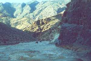
The fish barrier Dam below Cedar Pockets rest area has actually been run many times at varying flows. It has been raised once prior to 2019 and is now about 8 ft high. A warning sign is strung across the river several hundred yards upstream. There is a concrete portage ledge river right about 50 ft upstream of the dam that may be somewhat submerged at high flows. Left and right of center, the dam is perpendicular to the flow. At lower flows the left side has been run numerous times. In the center, the dam extends upstream in a vee and creates flow through the hydraulics. There is a horiontal concrete floor on the downstream side of the dam that extends bank to bank and about 40 ft downstream. The only way I have been able to key on it on approach to the V-notch is to stay on the highest peaks of standing waves that form upstream of the dam. The dam can be scouted from a large pull-out on northbound I-15 just upstream of the streamgage shelters near a chain-link fence.
A. C. Douglas warned:
Found your Virgin river site and want to make you aware of a new man-made hazard located on the run below Cedar Pocket. The attached photo shows a very large weir that has been installed on the last few years (Since the river was last at runnable levels). This structure is at least 10 feet high and is not visible from upstream until it is too late to avoid it.
My wife and I made the run from Bloomington to Desert Springs yesterday (4/29/11) and are lucky to be alive. We were running an Aire 156 oarboat and did flush through, but will never make this run again; the hazard is just too great.
PLEASE POST A CAUTION TO YOUR VIRGIN RIVER SITE TO MAKE PEOPLE AWARE.
Thanks,
A. C. Douglas
Boulder City, NV