Alcovy
1- US 29 to Alcovy Rd.(Upper Alcovy)
| Difficulty | II-III |
| Length | 2.5 mi |
| Avg Gradient | 45 fpm |
| Gauge | Alcovy River Near Lawrenceville, Ga |
| Flow Rate as of 31 minutes | 0.24 ftbelow recommended |
| Reach Info Last Updated | January 10, 2020 |
Gauge Info:
A good minimum is 200 cfs and rising
The gauge at the put in is the Alcovy at Lawrenceville.
http://waterdata.usgs.gov/ga/nwis/uv/?site\_no=02208050&PARAmeter\_cd=00065,00060 is at the put in.
2.7 feet at the put in is a good minimum, any lower and you might need to walk some rapids.
3.2 - some things are starting to get padded out, not so scrapy.
River Info
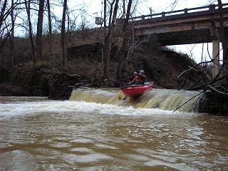
The Put-in is on the upstream side of the US 29 bridge. Just below the US 29 bridge is a little two foot tall stone dam. Look for enough water to paddle over dam cleanly, otherwise the run is going to be too low.
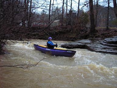
The Upper Alcovy is a nice little creek run near Atlanta. For an Atlanta area creek this little gorge gets an A for scenery. The first 2/3 of this run is solid Class II with a few poorly placed strainers. Most of the rapids are bedrock ledges. Two of these ledges can make a riverwide hole at higher flows.
A solid Class III rapid lurks in the middle of the run. This rapid is easy to spot since it consists of large boulders piled up in the creek. The rapid is in a right hand bend in the river. This rapid can collect some nasty wood. The water on river left feeds directly into the undercut so be careful. The conservative line is a hard right hand turn. This move is more difficult at higher flows.
After this rapid the river continues with its ledgy nature with a bunch more small slides.
There is a second much larger dam, about 15 feet tall, near the takeout. Its runnable at some levels. Please be careful with the dam and portage quickly. River left is the easier portage. The gradient between the dams is just over 100 feet (50 ft mile) but it is fairly constant.
The creek requires lots of water. That means a lot of rain, which leads to a lot of street run off. So, the water quality l
...Aug 11, 2021
The flood in July 2009 knocked this gauge's readings down by almost 2 feet. In 2010, cfs is no longer reported for this gauge. A level of 1.7 feet corresponded to the old 200 cfs recommended level after the shift.
Jun 3, 2010
A friend and I ran this earlier in the week and it seemed to have great potential. The level was pretty low and we had to scoot our boats and push ourselves down every rapid. There were 4 river-wide strainers (2 we portaged and 2 we could squeeze under the downed tree). There were many interesting looking rapids along the way that would be great at high water. I suggest, as a general rule, if you can't clear the 1st rapid without scraping, wait until the level is higher. This short stretch took us over 2 hours to run at this scrapy level. Overall a neat river and one that I want to do again.
Dec 31, 2006
at 3.2 feet, we were able to run the dam. Two tree portages, but about 6 others requiring some limbo moves, and maybe three you could boof over. I'l still like a little more water, say 3.5 and up. Alcovy is not as flashy as rottenwood or sope. Smaller rapids than those two as well.