Trip Reports
Log in to add a reportSS
Two Canoes - Seth Scott
Jan 13, 2024
Went down and had a complete clear run. Put in at Lindsey Ford and took out at Hwy 53. There were several dead falls the last trip I had out on this section. This trip happened about a week after a massive flood. River clear.
BD
Brent Duncan
Jan 21, 2013
Did this section yesterday with 2 other friends. Had a great time the level was at 1.25. We ran into no problems except some bone chilling water!
?
Untitled
May 5, 2011
6-mile Put In - Devil's Elbow (6/29/07)
Two man trip in recreational kayaks. Two men who get recreational in other ways if you catch my drift. No unavoidable hazards. Probably as low as you would want to attempt running. Necessary to find deepest channels. 5.85 miles in 2:08.
JO
John Orr
Mar 14, 2011
I ran this run on 3-12-11 @ 1.25'. Here's a video I made http://www.youtube.com/watch?v=OHIZzkO8KSk.
?
Untitled
Aug 31, 2009
We ran this on Aug. 30 of 2009. Most of yall probably know this, but there are three river wide trees from six mile to the 53 take out. The first two are in calm water (we picked up our canoe and slid it over the first one). The second one we were able to climb over the tree and slide our canoe under its far right side. That only works in low water.
The third one is tame enough but could mean trouble at higher water (we ran it at around .53). If there is enough water, you can paddle around the far right side of it.
I didn't submit this as a hazard, because I don't want to scare people away.
All in all, the river is still totally worth running and we had a complete blast. Kevin
?
Untitled
Jan 12, 2009
A group ran the amicoloa 1/11/09 and the online guage was 1.2'. The river was very doable and rapids were solid class II. The hole on the last rapid before the take out was sticky and flipped a few folks, but still very safe. I enjoy playing with it on this river.
?
Untitled
Dec 15, 2008
Had a great trip down Saturday 12/13/2008 water level about .9 ft with my wife (she is black). This is a great level with minimal rock scraping and the rapids are still tame. We saw a canoe pinned down in a tree, about a mile above Devils elbow. Looked like from the previous day, all the gear was still inside. A new tree also got deposited on the ledge that is about 75 feet long.
?
Untitled
Oct 11, 2008
River low (.43). River Fun. Dad + 5 year old + 7 year old = 'The best day ever!' We left some paint on some rocks but had a blast. Were unable to run the second to last rapid because water level. Kids final verdict - 'Let's do each other again tomorrow!'
CM
Carla Miner
Jun 10, 2008
Eli Kesting- I live in dawsonville and have been in love with this little river since day 1! a local group of boy scouts or forestry service has built a wooden walkway from the bridge to the edge of the wold no more lugging boats through the woods! and there is also a lot more parking available at the bridge than before an a nice take out right before the bridge. this is a great run and me and my friends really enjoy it hopefully you will too!
JH
Jamie Higgins
Apr 16, 2007
On April 15, 2007, A group of GCA members paddled the Upper Amicola. The gauge at the hwy 53 bridge showed the creek was running at .65. The river was scrapey, but runnable. Also, there were no river-wide, impassable strainers in the creek.
?
Untitled
Sep 15, 2006
My wife and I paddled the upper section from 6 mile put in, Sept. 14 at 1.0.
There is a new river-wide downed tree between the ledge and Devil's elbow. From there I thought she didn't mind the back door and I got greedy. It's in a flatwater section but could be a real problem at high levels..........strainer limbs on one end and massive poison ivy vine on the other. I'd take my chances with the strainer..........I'd paddle a class VI with a strainer before I'd get anywhere near poison ivy. River was fairly clear everywhere else. david
RB
Rick Bellows
May 15, 2006
Edward Stockman led a GCA trip on 05/14/06 at .45 on river gauge, .8 on online gauge. Reports 4 new river-wide strainers above Devil's Elbow, only 1 of which needed to be portaged at that level. Also reports large strainer 1/2 mile from top is now clear.
RB
Rick Bellows
Mar 16, 2006
The Etowah Scenic River Committee is working to have 6.8 miles of the Etowah River and 14.4 miles of Amicalola Creek, mostly within the Dawson Forest Wildlife Management Area, included under Georgia
RB
Rick Bellows
Nov 8, 2005
UPDATE: The new bridge carrying Afton Road over Amicalola Creek is done (and I obviously overestimated how long it takes to build a bridge nowadays). If you want to avoid the deadfalls above Afton Road, you can put in under the bridge: access looks to be easier at the southwest of the bridge than at the the northeast end.
BR
Brad Roberts
Oct 13, 2005
New usgs gauge. Hopefully added to the database soon on aw gauge page. keep your eyes out for it.
DC
Dan Centofanti
Jul 5, 2005
Etowah Scenic River Proposal
A grassroots organization, the Etowah Scenic River Committee, has been formed to protect 21 miles of the Etowah and Amicalola Rivers in North Georgia. The group is lobbying to have sections of these river designated State Scenic Rivers, in accordance with the Georgia’s State Scenic River Act. The Etowah Scenic River Proposal includes 14.4 miles of the Amicalola River, from Lindsey Ford to the confluence of the Etowah River. The study will also include 6.8 miles of the Etowah River. Much of these streams flow across the City of Atlanta tract of Dawson Forest. The proposal follows the requirements of the Georgia Scenic Rivers Act, which protects the river corridor and does not allow dams or other obstructions to the free flowing nature of the river.
These two streams are located in Dawson County within a one-hour drive of most of Metropolitan Atlanta. The area surrounding these streams is heavily wooded and there are no cabins or decks on the banks for the entire 21 miles! This is indeed rare in our rapidly developing area just outside the urban sprawl of metro Atlanta. The Etowah is home to 76 species of aquatic life making it one of the richest rivers in aquatic diversity in the southeast according to Candace Stoughton, Etowah River Project Director for the Nature Conservancy. The Amicalola is a popular canoe and kayak run, with several sections ranging in difficulty from Class I-II on the Upper Amicalola to Class III-IV on the Lower Amicalola.
In the early 1970s, the City of Atlanta purchased 10,000 acres in Dawson County with an eye to building a second airport. When the property was deemed too hilly for the project, the area was left undisturbed and eventually came under the management of the DNR’s Wildlife Resources Division and the Georgia Forestry Commission. Public access and recreational facilities were improved and a forest stewardship program was established. The has become a lush haven for hikers, campers, canoeists, hunters and fishermen. But, the City of Atlanta still contends that the land is reserved for a future airport. The Etowah Scenic River Committee came together after an article was published in the Atlanta Journal Constitution in January about renewed interest in a second airport and a high speed rail link along Highway 400 to Hartsfield-Jackson International Airport. Due to the rapid development of North Metro Atlanta and the tremendous increase in land value, this 10,000 acre tract is again being eyed for future development projects. Some local real estate brokers have aggressively opposed the Scenic River proposal because they have a large developer interested in the purchasing the tract. Designation of the Etowah and Amicalola as State Scenic Rivers would offer the rivers some protection even if the Dawson Forest is developed.
Leading the Etowah Scenic River Committee is Bill Hess who retired to Dawson County with 30 years experience with the U.S. Forest Service and was responsible for wild and scenic rivers studies in the southeastern states for the Forest Service. The committee has completed the first step of the process, which is local education and support of the proposal. Accomplishments to date include a informational web site, a town hall meeting of over 200 people, and a petition drive that garnered over 1,500 signatures encouraging the county to take action to protect the rivers. The petition was presented to the Dawson County Commissioners at their April 7, 2005 meeting. The commissioners agreed to endorse the proposal but have not sent it to the governor. The committee has also hosted a canoe trip and hike where local commissioners, Representative Amos Amerson, Atlanta City Council member Felicia Moore, Advisor to the governor Terry Demeo-King, as well as media representatives and others were present to discuss and tour the rivers and the proposal.
A major obstacle to the efforts of the committee is the City of Atlanta. As owners of the tract, the entire Atlanta City Council must approve any proposed action. The Georgia Scenic Rivers Act was passed in 1969, but has rarely been used. Designated waterways must be found to have outstanding scenic and recreational qualities. There are only four rivers that have made the list – The Conasauga and Jacks Rivers in the Cohutta Wilderness in northwest Georgia, a portion of Ebenezer Creek near Savannah and the Chattooga River in northeast Georgia. The Chattooga is also a National Wild and Scenic River.
AW is calling on its members for action to help with this proposal. Here is what you can do to help protect our local treasures:
#1) Call, write, and e-mail Governor Sonny Perdue, Dawson County State Legislature Representatives (Chip Pearson, Amos Amerson, and David Ralston), Mayor Shirley Franklin, and all the Atlanta City Council Members, epically the transportation committee. Tell them how much you value these rivers and you support the proposal of making them State Scenic Rivers.
#2) Help us spread the word. Tell family, friends and others about the proposal. We need strong public support to get this passed.
For additional information, contact information, sample letters, and on-line petitions visit www.EtowahScenicRiver.org.
Many AW members are familiar with these wonderful rivers. The AW Amicalola web page is also full of great information. We request that everyone do their part to help get this proposal passed. For additional information or opportunities to volunteer feel free to call Dan Centofanti at 770-380-1488.
BM
bobby mcneal
Aug 4, 2003
i went down this run on sat. 8/2/03, it was great run other than there was a lot of spots that was log jammed other than there was anough trees to build a house in the river. if there is anyone in this area that would be interested in helping cut some trees out let me know. my e-mail is mcneal316@yahoo.com
CL
Connie Logsdon
May 5, 2002
The Falls consist of a river wide ledge,about 4',with a shallow pool below.
This small creek has several smaller type drops which makes for excellant training.
I've heard this section of river can be run as low as .5
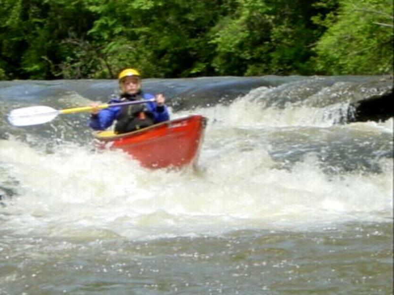
Gabriella cuttin through with a light touch and tight line!
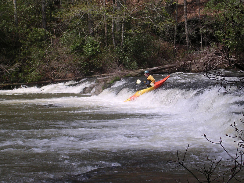
Pat drops over another typical ledge on the Upper A.