Chattooga
Section 2 - Highway 28 Putin to Earl's Ford
November 6, 2006
| Reporter | Steve Reach |
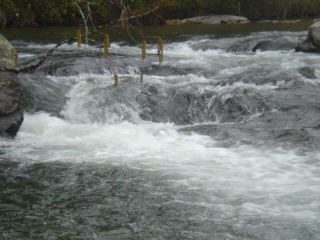
Ran Sec2 on 11/5 at @1.28 ft. Tediously scrapey in shoals. Did a LOT of knuckle walking - made a long day. Big Shoals was dry except for the chutes at either end of the ledge. The river-right chute looked dangerous, all the water dumped down into a rock sieve. The left line was OK if you missed the overhang but directly below was a lot of exposed rock that would have been another knucklewalker, so we portaged down the normal middle line. I would recommend the lower limit for this run be jacked up to maybe 1.4 or 1.5 ....
This is a longish trip (7 miles?) with a lot of flatwater. It's beautiful and wild though and we had it all to ourselves. Water was very cold and clear, saw a HUGE school of big brown trout in one place. You can spot the Earl's Ford takeout pretty easily by the presence of a big sand beach on the left with wooden stairs leading to the trail up to the parking lot, a small campground and a side creek on river right. If you parked in the Earl's Ford parking lot on the SC side, make sure you take the southernmost or right-hand trail, which can be recognized by it being relatively flat, gradual and wide enough to drive a vehicle. The northern or left trail (steeper, narrower and covered in horse manure and hoof prints) will get you lost in the woods. Also: I strongly recommend shuttling on the SC side (12 miles each way) because the road on the GA side is incredibly twisty - it'll take longer and be more dangerous to drive. However, you can apparently drive right down to the river on that side, something to think about if you aren't up to the 'Chattooga Carry'.