Chestatee
3 - Copper Mine to Lumpkin County Park
June 5, 2011
| Reporter | John Weeks |
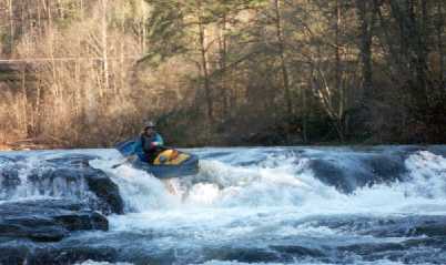
My wife, daughter and I ran the section from Coppermine to Appalachian Outfitters Saturday 06-04-2011. The reported flow was 205 cfs and the gauge showed 1.1 feet. The run was extremely rocky. We scraped along the bottom of the river at nearly every fall, rapid, or ripple. While we never had to exit our boats to drag off rocks, it was a bit aggravating and did affect our ability to line up for runs. The options for running the various falls and shoals disappear at this low level an you often find yourself with but a single option, other than a portage, for passing a fall or rapid. This can create difficult and dangerous situations due to the lack of room to maneuver in a rapid or fall or to avoid sieves. If you plan to run this section at low levels be prepared to deal with shoals, sieves, and other obstructions that are under water at higher water levels.
Finally, the distance from the intersection of Hwy 9 and Hwy 52 to the bridge at coppermine is 1.8 to 1.9 miles and parking can be tricky as it is strictly roadside parking at the bridge.