Conasauga
Chicken Coop Gap to East Cowpen Road - Upper(Upper Conasauga)

| Difficulty | III-IV |
| Length | 7.4 mi |
| Avg Gradient | 80 fpm |
| Gauge | Holly Creek Near Chatsworth, Ga |
| Flow Rate as of 1 hour | 43 cfsbelow recommended |
| Reach Info Last Updated | May 5, 2025 |
Northern Georgia Canoeing, Sehlinger, B. and Otey, D.
Appalachian Whitewater: The Southern States
Put In for Upper Consauaga: Finding the put-in is the hard part. From the take-out drive up West Cowpen Road to Chicken Coop Gap. For lack of a better description, go about four miles up West Cowpen, then look for a turnout on the left. You should be able to just barely see the river at the bottom of the hill if there are no leaves on the trees some 250 vertical feet below.
From there carefully carry your boat (or lower it on a short leash) down a shale and mud covered steep incline (borderline cliff) to the river.
Gradient by mile: 91, 56, 56, 128, 66, 40 ft/mi. .
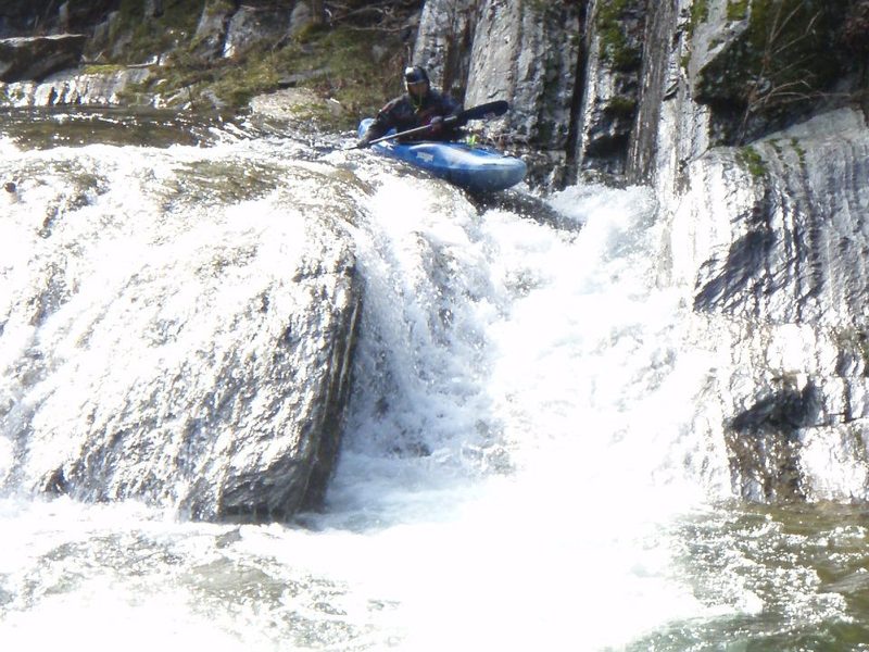
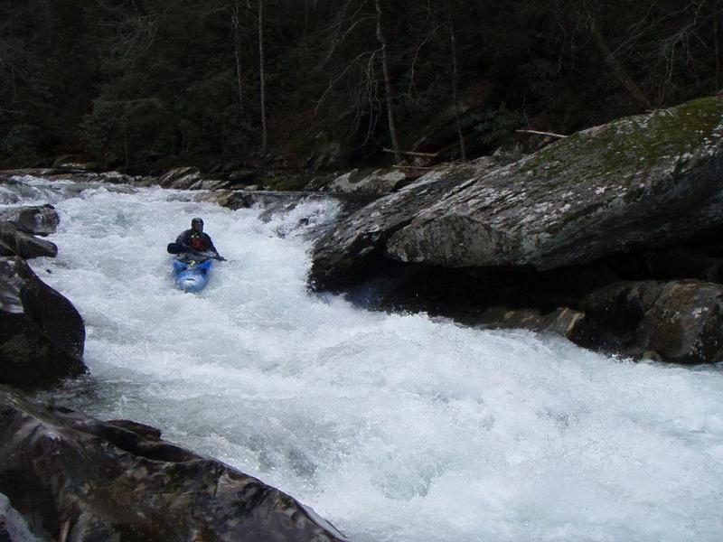
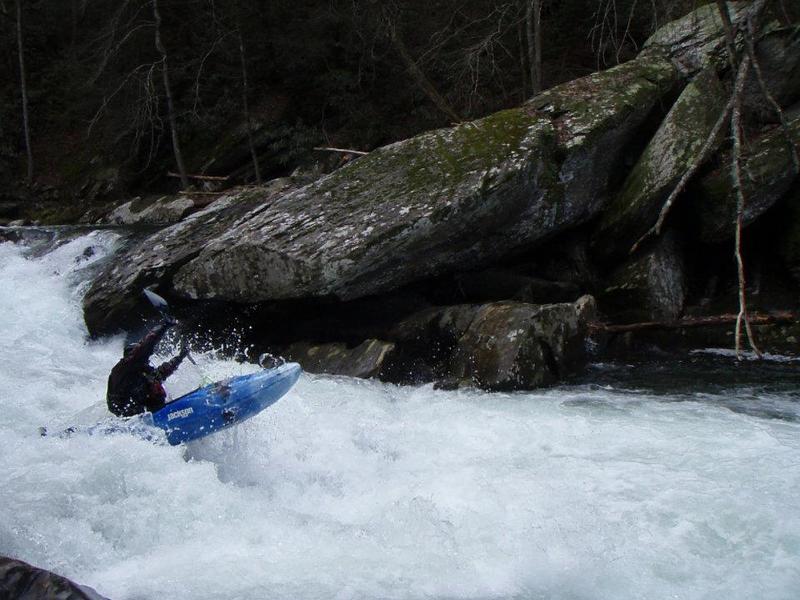
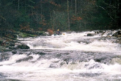
The first few miles after the Chicken Coop Gap put-in offer a nice warm-up leading up to the major rapids. The four big drops, all located in that steep (128 ft/mi) fourth mile, are IIIs and IVs. The most difficult are Undercut (aka Room of Doom) and Whale Tail. They will be obvious, especially Whale Tail with its impressive roostertail of water.
Keep an eye out for wood in all of the major drops. Another thing to watch out for is rebar in the drops. About 100 years ago this area was extensively logged and the rebar is leftover from the logging.
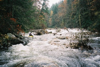
The Upper Conasauga is a beautiful wilderness run. People have put on higher than Chicken Coop Gap and report that it is a great run, though it does require quite a bit of work to get to the river.
Directions to the Upper Upper put-in from Boatertalk:
'I don't remember the exact mileage, but from the take-out. Go back in the direction that you came in, take the first left up a steep hill. At the fork stay right, when the road T's, go left. This will dead end @ a trail head. It is probably a 20 minute hike downhill to the creek. Total driving distance is probably 8-10 miles. There is section below the put-in with class III - IV fun, it's all read & run same as th
...Park anywhere along this straight, level section of road that parallels the river (albeit way high above the river) along the ridge.. The trailhead is inconspicuous. Look for it near the curve at the north end of the straight stretch.
Ledge drop. Multiple routes depending on water levels and wood.
A big S-turn rapid. The holes at the bottom can get large.
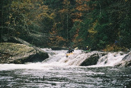
Slide high on the rock shelf to stay out of the undercut.
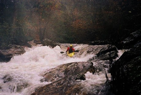
Drive left around the big roostertail floom of water. Or portage on the right.
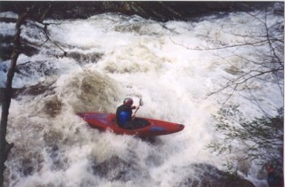
AKA Pinball, is a few hundred yards below Whale Tail. It is recognized by a house-sized boulder on river left which is undercut. When entering this rapid stay away from the top of that large boulder. It appears to have an eddy above it but it funnels into a bad sieve. This one is best run by starting top right, then hitting the boof on the right side. Avoid the pinning rock in the bottom middle. Portage on the right.
Public land is on the downstream side of the bridge. Upstream of the bridge is private property.
Sep 29, 2024
4' was a good moderate level on Sept 28 2024 two days after Hurricane Helene blew through.
It's necessary to dig through the sand around the bridge piling to get a proper gauge reading.
Holly Ck was running 200 cfs at the time.
Mill Ck was running 40 cfs at the time.
Feb 25, 2019
Do NOT park at the pull off near where the road and river get close to take out. This is the location https://goo.gl/maps/P2rfph1kegx - Again, do not park there because of landowner issues!
Park at the Old Hwy 2 Bridge. Here is the location: https://goo.gl/maps/9djvNC9wYAy
This is also where the gauge is located. There is USFS land at this bridge, park there (not on the private land side of the river).
Feb 3, 2013
After the flood from Ivan we ran this in a large group of 9 at a higher flow. All rapids was clean of strainers but a hazard has threatened the life of one boater. The last rapid has a housed sized boulder that is badly undercut. It is easly avoided to the right but looks like it has an eddie above it. When a few got blew off line and went left to the eddie above the rock, one boater was sucked under the large boulder from the eddie. When pulling his skirt, the boat went out from in under him and he reached up an felt some wood to pull himself out from in under this rock. His paddle flushed through but boat stayed in. Its like a large funnel with a 3x3 exit and could hold a few boats. Avoid this rock. There is realy only two house sized boulders on the conasauga. One on the Upper Upper that creates a slot to the left. The other is on the left in the last major rapid on the Chicken Coop section. I think the best way to internet gauge anything in the cohuttas is going to be with the usgs Mill creek gauge AW #8361 near Crandall. Haven't got anything dialed in yet but around 2.5ft on the online gauge shows a good clue of water in the cohuttas. I also have a Stick gauge where the old elbow tree was. Its river left 20ft upstream from the elbow. 1.8 is a good minimum and if the gauge is under water its high. 1.8 is 0.6 on the old hwy 2 bridge gauge.
Feb 8, 2011
Jason Hall and myself ran this sections Sunday 2/6/11. Super low water, another half inch to inch lower and we would have been in for it. All in all it was a good day. It was my first time on the run. The gauge at the take-out was reading about 6 inches when we took out. According to Jason, who has ran in many times at different levels (higher) said he hardly recognized the run until we got to the last 4 or 5 rapids. I don't recall the order of the rapids. Whale tail was sketchy at such a low level, a rock on just to the left of the tail comes into play that created a recirculating eddy back in the hole that the tail was making. Nothing to bad, I was put into it, just had to man handle the water a little bit and paddle back towards the tail and grab the downstream water. Jason said at higher levels that rock is not in play but actually forms a decent hole. Room of Doom was super sweet at the level actually, of course It was my first time and I dont know about it at higher levels. It was a good boof and you felt like you clear your head by an inch from the over hanging rock that forms the Room. Just boof hard. Other than that, there's not much more to tell. 6 inches is definitely the absolute minimum. I would recommend no lower than 9 or 10 inches. see ya out there.
Huston Pope
Nov 16, 2009
I think these are correct locations and mileages for the major rapids.
Three Ledges Rapid
lat/long: 34.9429, -84.6498
3.2 miles from Coop
Room Of Doom
lat/long: 34.9455, -84.6525
3.6 miles from Coop
Whale Tail Rapid
lat/long: 34.9469, -84.6527
3.7 miles from Coop
Pinball Rapid
lat/long: 34.9490, -84.6566
4.0 miles from Coop
Jan 18, 2006
The paddler's gage for this run is on the East Cowpen Road bridge. Its on the upstream river left bridge support. The bridge is 2 miles downstream of the take-out. 4' is probably minimum. My guess is that 1 foot is medium and 1'6' is probably high. I've heard of a group running it as low as 0', but that would be an ELF run (Extrememly Low Flow.
A good way to gage if the Conasauga is running is to check 02385800 HOLLY CREEK NEAR CHATSWORTH, GA. If it is over 300 cfs the upper is probably running.
P.S: the old Elbow Tree has finally rotted and fallen into the river. Its now useless as a gage for the river.