Conasauga
Chicken Coop Gap to East Cowpen Road - Upper(Upper Conasauga)
Sep 29, 2024
4' was a good moderate level on Sept 28 2024 two days after Hurricane Helene blew through.
It's necessary to dig through the sand around the bridge piling to get a proper gauge reading.
Holly Ck was running 200 cfs at the time.
Mill Ck was running 40 cfs at the time.
Feb 25, 2019
Do NOT park at the pull off near where the road and river get close to take out. This is the location https://goo.gl/maps/P2rfph1kegx - Again, do not park there because of landowner issues!
Park at the Old Hwy 2 Bridge. Here is the location: https://goo.gl/maps/9djvNC9wYAy
This is also where the gauge is located. There is USFS land at this bridge, park there (not on the private land side of the river).
Feb 3, 2013
After the flood from Ivan we ran this in a large group of 9 at a higher flow. All rapids was clean of strainers but a hazard has threatened the life of one boater. The last rapid has a housed sized boulder that is badly undercut. It is easly avoided to the right but looks like it has an eddie above it. When a few got blew off line and went left to the eddie above the rock, one boater was sucked under the large boulder from the eddie. When pulling his skirt, the boat went out from in under him and he reached up an felt some wood to pull himself out from in under this rock. His paddle flushed through but boat stayed in. Its like a large funnel with a 3x3 exit and could hold a few boats. Avoid this rock. There is realy only two house sized boulders on the conasauga. One on the Upper Upper that creates a slot to the left. The other is on the left in the last major rapid on the Chicken Coop section. I think the best way to internet gauge anything in the cohuttas is going to be with the usgs Mill creek gauge AW #8361 near Crandall. Haven't got anything dialed in yet but around 2.5ft on the online gauge shows a good clue of water in the cohuttas. I also have a Stick gauge where the old elbow tree was. Its river left 20ft upstream from the elbow. 1.8 is a good minimum and if the gauge is under water its high. 1.8 is 0.6 on the old hwy 2 bridge gauge.
Jan 30, 2012
The bottom portion of Pinball, A couple a rocks in the middle give this rapid it's good name.
Jan 30, 2012
Pinball @ .4' on the bridge gauge, Ran right down the center. This is the rapid with the sieves at the top on the River left eddy. You see the water coming through the bottom. 1-27-2012
Jan 30, 2012
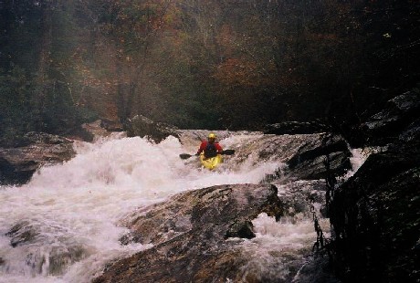
Here is a sneak line for Room of Doom. Run on far river left. Level was 4' on the bridge gauge..1-27-2012
Feb 8, 2011
Jason Hall and myself ran this sections Sunday 2/6/11. Super low water, another half inch to inch lower and we would have been in for it. All in all it was a good day. It was my first time on the run. The gauge at the take-out was reading about 6 inches when we took out. According to Jason, who has ran in many times at different levels (higher) said he hardly recognized the run until we got to the last 4 or 5 rapids. I don't recall the order of the rapids. Whale tail was sketchy at such a low level, a rock on just to the left of the tail comes into play that created a recirculating eddy back in the hole that the tail was making. Nothing to bad, I was put into it, just had to man handle the water a little bit and paddle back towards the tail and grab the downstream water. Jason said at higher levels that rock is not in play but actually forms a decent hole. Room of Doom was super sweet at the level actually, of course It was my first time and I dont know about it at higher levels. It was a good boof and you felt like you clear your head by an inch from the over hanging rock that forms the Room. Just boof hard. Other than that, there's not much more to tell. 6 inches is definitely the absolute minimum. I would recommend no lower than 9 or 10 inches. see ya out there.
Huston Pope
Nov 16, 2009
I think these are correct locations and mileages for the major rapids.
Three Ledges Rapid
lat/long: 34.9429, -84.6498
3.2 miles from Coop
Room Of Doom
lat/long: 34.9455, -84.6525
3.6 miles from Coop
Whale Tail Rapid
lat/long: 34.9469, -84.6527
3.7 miles from Coop
Pinball Rapid
lat/long: 34.9490, -84.6566
4.0 miles from Coop
Jan 18, 2006
The paddler's gage for this run is on the East Cowpen Road bridge. Its on the upstream river left bridge support. The bridge is 2 miles downstream of the take-out. 4' is probably minimum. My guess is that 1 foot is medium and 1'6' is probably high. I've heard of a group running it as low as 0', but that would be an ELF run (Extrememly Low Flow.
A good way to gage if the Conasauga is running is to check 02385800 HOLLY CREEK NEAR CHATSWORTH, GA. If it is over 300 cfs the upper is probably running.
P.S: the old Elbow Tree has finally rotted and fallen into the river. Its now useless as a gage for the river.
Dec 14, 2004
The paddler's gage for this run is on the East Cowpen Road bridge. Its on the downstream river left bridge support. The bridge is 2 miles downstream of the take-out. 4' is probably minimum. My guess is that 1 foot is medium and 1'6' is probably high. I've heard of a group running it as low as 0', but that would be an ELF run (Extrememly Low Flow
A good way to gage if the Conasauga is running is to check 02385800 HOLLY CREEK NEAR CHATSWORTH, GA. If it is over 300 cfs the upper is probably running
P.S: the old Elbow Tree has finally rotted and fallen into the river. Its now useless as a gage for the river.
Nov 16, 2002
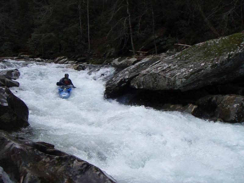
Ran this thing on Nov. 16, 2002. Good water, maybe on the low side of good. We put in 1.25 miles past the tradition chicken coup gap put-in. There will be a gated forest service road on the right, and a two car pull out on the left. On the left is a fishermans trail down to the river. This is a much easier trail to the river than the standard chicken coup gap trail. First half of the run is mostly Nantahala style class 2. Probably 3 or 4 miles worth. The good stuff is in the bottom half of the run. There are maybe three class 4 rapids. Everything else is boat scoutable class 3. On this date everything was pretty clear of trees. Good intro to creeking run.
Nov 7, 2002
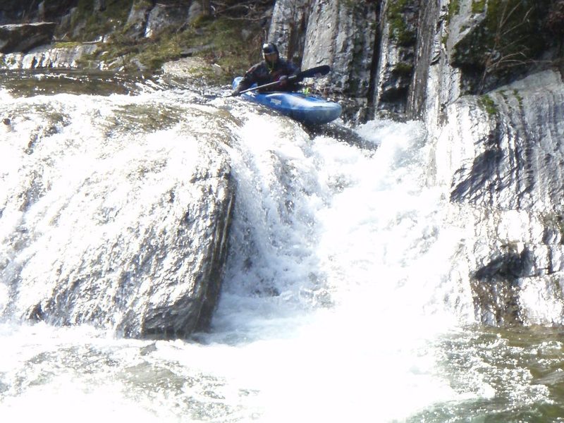
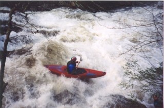
This is a good line thru Room of Doom. Beware the undercut on river right. Also be careful of the re-bar around this rapid.
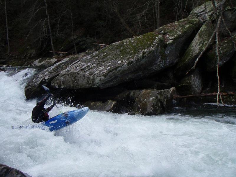
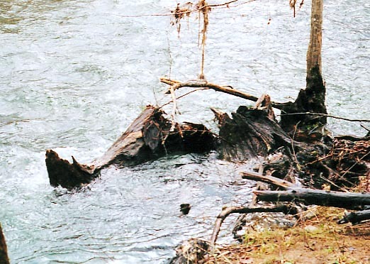
This is what getting stuffed into an undercut looks like
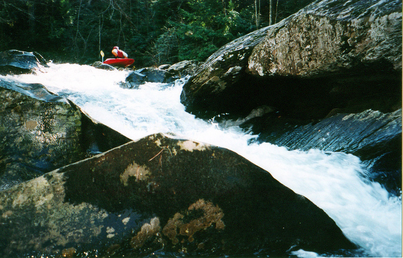
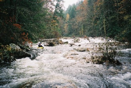
Whale tail is the major drop on the conasauga. Seen from above a midstream rock kicks up a 8 foot floom of water in a half crescent shape. The move is to bust right to left around the the floom, but not get caught in the guard eddy beside it. Portage right.
Jan 1, 1900
The East Cowpen Road Bridge Gage is 2 miles downstream of the take-out. Located on the upstream river left side of the bridge. 4' is probably minimum. At 7' it was medium-low.
For years, or should I say decades, the 'Elbow Tree' has been the way to gage if the Conasauga is running. Well, it died, rotted and fell into the river. This is whats left. Now the official gage is the East Cowpen Road Bridge gage. Located 2 miles downstream. 3' is probably minimum for this section of the Conasauga.