Conasauga
Chicken Coop Gap to East Cowpen Road - Upper(Upper Conasauga)
February 3, 2013
| Reporter | Simon Bishop |
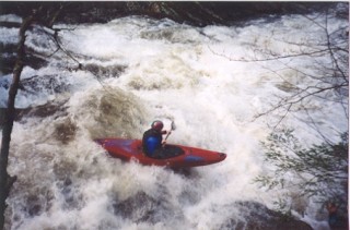
After the flood from Ivan we ran this in a large group of 9 at a higher flow. All rapids was clean of strainers but a hazard has threatened the life of one boater. The last rapid has a housed sized boulder that is badly undercut. It is easly avoided to the right but looks like it has an eddie above it. When a few got blew off line and went left to the eddie above the rock, one boater was sucked under the large boulder from the eddie. When pulling his skirt, the boat went out from in under him and he reached up an felt some wood to pull himself out from in under this rock. His paddle flushed through but boat stayed in. Its like a large funnel with a 3x3 exit and could hold a few boats. Avoid this rock. There is realy only two house sized boulders on the conasauga. One on the Upper Upper that creates a slot to the left. The other is on the left in the last major rapid on the Chicken Coop section. I think the best way to internet gauge anything in the cohuttas is going to be with the usgs Mill creek gauge AW #8361 near Crandall. Haven't got anything dialed in yet but around 2.5ft on the online gauge shows a good clue of water in the cohuttas. I also have a Stick gauge where the old elbow tree was. Its river left 20ft upstream from the elbow. 1.8 is a good minimum and if the gauge is under water its high. 1.8 is 0.6 on the old hwy 2 bridge gauge.