Lolo Creek
2. Cottonwood Flats (near State Meadows) to Clearwater River
| Difficulty | IV+ |
| Length | 11 mi |
| Avg Gradient | n/a |
| Gauge | Lolo Creek Nr Greer Id |
| Flow Rate as of 867 days | 568 cfsstale data |
| Reach Info Last Updated | April 21, 2021 |
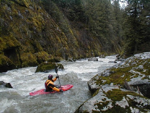
Lolo Creek is a beautiful run in the Clearwater basin in Idaho. It's fairly remote down in the deep canyon, not a place you'd want to hike out of. The rapids are mostly class 4 at normal flows. As the water rises, the river gets extremely pushy and the individual rapids approach class 5. Wood is a constant danger because the canyon sides are steep and occasionally landslides will push more dead trees down towards the river.
The take-out is just up from the small town of Greer. On an Idaho map, Find Orofino on Hwy. 12, east of Lewiston. Greer is just 11 miles east of Orofino. Turn off Hwy. 12 onto Hwy 11, which crosses the Clearwater, goes through Greer, and winds its way up the grade towards Weipe, Pierce, Headquarters, and the NF Clearwater. About 1 mile past Greer as you head up the grade you'll see a small marked gravel road heading down to your right. Drive a mile or two down that gravel road to a bridge that crosses Lolo Creek. This is the take-out. Check the gauge from the bridge.
To get to the put-in, head back out to Hwy. 11 and turn right up the grade. Follow Hwy. 11 all the way up the hill. As the road flattens out, you'll pass the small 'town' of Frasier. A couple miles before Weipe, look for 3-Mile Road on your right. Turn right onto 3-Mile Rd. and follow that for maybe 8 or 10 miles. Be on the lookout for roads on your right. The one you're looking for is called Lolo Creek Rd., and it is marked with a sigh but the sign is blocked by some mail boxes, so it's easy to miss. Turn right on Lolo Creek Rd. and follow it all the way back down to the creek. There's a Forrest Service or BLM trailer here, and there's usually a rotating fish trap just under the bridge. This is the put-in. (Grant Amaral's guidebook references an upper put-in, but the copuple extra 3+/4 rapids you'll get to run aren't worth the added time it takes to get there, and the potential for getting lost trying to find it...)
From the standard put-in, you'll float around
...Jun 10, 2021
Our group of 4 did a run on 5/28/21. 2.75 on the put-in gauge. Could not find a takeout gauge. As none of us had done it previously, we estimated it was a good, low side of medium flow. It took us 7.5 hours, longer than normal due to us taking our time. None of the rapids were show stoppers. None of the wood was a showstopper ... but we probably portaged approx 8 times, ducked 2 or 3 logs, and did purposeful flips under 1. Great scenery, quality whitewater. We were all glad to get it.
Jun 9, 2019
We ran it yesterday. I have a few points people could find helpful. 1.) We had around 450 CFS. It was a great level for a low water run, I do not think I would run it much below 400. 2.) One of the guys had a Garmin tracking him and it showed the run was 18.8 miles. It is a long day. 3.) There is a new rapid below Land Slide. The new rapid is also caused by a landslide. Yesterday it is was a trashy class 3 drop. It has an overall drop of several feet and will be worth a look for a couple of years as I am sure it will be changing from year to year
May 31, 2017
Ran Lolo May 29, 2017 @ ~525 cfs on the new gauge. This was LOW. Might be considered a fine flow for southeast boaters but Idaho folk would want 800-1000 to consider it a worthy day out, and likely would want much more if you know the river. Occasional obvious wood in play but for Lolo i think it would be considered quite clean.
May 16, 2014
Youtube helicopter scout of Lolo posted by Clearwater County:
https://m.youtube.com/watch?v=-i1QpWiioGg
Feb 23, 2008
I just changed the rating on this stretch from III-IV to IV+.
Lolo Creek is long and remote. Stories of hike outs range from daunting to epic. Most of the rapids are not super hard, but they will definitely be a serious test to anyone who is not super comfortable running continuous and sometimes blind class IV boulder drops.
In addition, portaging these rapids is difficult. You should probably plan on running just about everything except for the Landslide Rapid (an easy portage...but the drop is also cleaning up lately). While Zig Zag and Big Schmidt are definitely portageable, portaging these two rapids could potentially add an hour to an already long day.
That said, this is an awesome run that should put a smile on the face of all but the most jaded gnarstar.
Mar 20, 2007
Paddled it last weekend on 3/18/07. It was at 11 Ft. Portaged 3 Logs. Check my website: www.infinitymountain.com for photos. Have fun.
