Pigeon Creek
Bonniwell Road to Highland Road (1.2 - 2.4 miles)
| Difficulty | II |
| Length | 2.6 mi |
| Avg Gradient | 50 fpm |
| Gauge | Menomonee River at Menomonee Falls, Wi |
| Flow Rate as of 36 minutes | 2 cfsbelow recommended |
| Reach Info Last Updated | April 25, 2026 |
Quick Facts
Location: A mile north of Thiensville, 3.3 miles south of Cedarburg.
Put-in: 43.2653, -88.0137 (8340 W.Bonniwell Road, Mequon; ask permission from property owner)
Take-out parking: Highland Woods, Green Bay Road, Mequon
Shuttle:: 2.7 miles/5 minutes
Put-in is approximately 792' elevation.
Take-out is approximately 669' elevation.
Thus total elevation change is approximately 123'.
Gradient Average: approximately 50 FPM.
IMPORTANT NOTE: Gradient values should be used for general comparative purposes only! Differences (even up to 15-20% and more) mean very little in the grand scheme of whitewater! (Streams with gradients in excesss of 50 FPM may be swiftwater with no meaningful rapids!)
Class/rating can also mean relatively little. Short, not overly complex rapids may be rated as III or IV (or even V), and may be run by inexperienced boaters without serious mishap! Conversely, there are complex, technical class II boulder-garden rapids which often cause upsets, injuries and even death among inexperienced boaters! Never rely solely on class/rating to decide if you should run a river/rapids!
Far more important than either gradient or class/rating are other less-quantifiable 'character factors' such as: (1) continuous versus pool/drop, (2) wide-channel with multiple routes versus narrow channel with essentially one route, (3) straight-shot routes versus complex technical maneuvering-required routes, (4) gradual river banks versus rocky shores or steep-walled gorges, (5) heavily wooded (prone to strainers, sweepers, deadfall) versus just shrubs, grasslands, or non-vegetated surroundings, et cetera.
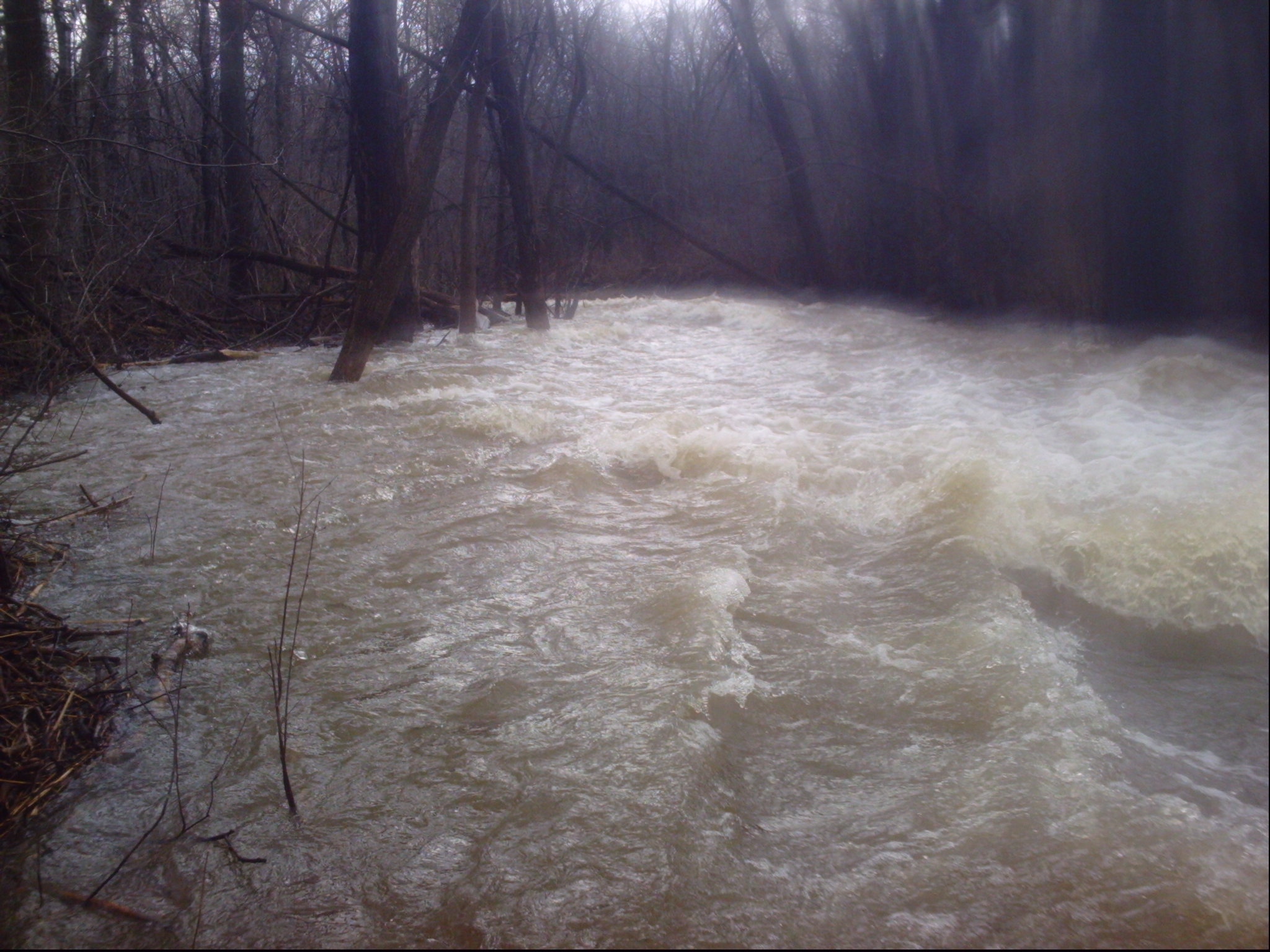
Character: Extremely narrow meandering rural stream with deadfalls, snags, shallow braided channels, impassible culverts (and some passable ones), electric fences, and areas of bedrock slides. Recommended only for true masochists with solid boating skills!
River banks: Al
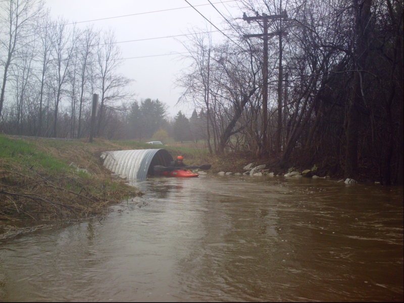
If you aren't comfortable passing through this culvert at the put-in, don't even think of running the rest of this creek! (If the water is high enough that you can't make it through, there are a number of spots which will be VERY dicey, and you really shouldn't be on the run!)
Drainage at this point is only ~3.5 square miles!

As you approach a private estate, you will encounter a set of culverts for a driveway, followed shortly by a small low footbridge. At low flows it may be possible to boat through the culvert and duck under the footbridge. At moderate to higher flows, it will be necessary to portage. Carry as quickly and discretely as possible, portaging both at once. Putting in immediately after the footbridge, you will have a (very short) rocky rips before you enter a pond in the yard of this estate. Please be careful to skirt wide around their ironwork sculptures in the pond as you head to the short dam which is the outlet for the pond.
Width: 8'-10' Height: 1'-2'
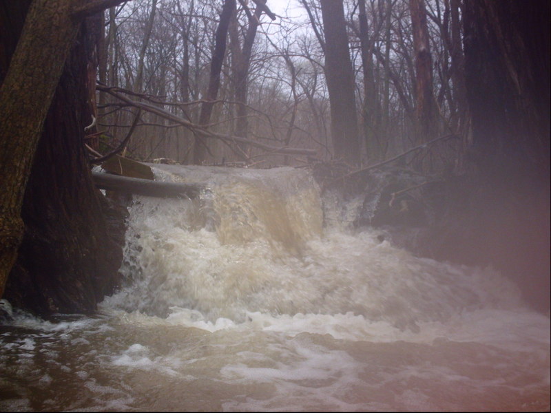
A minor rocky rapids leads to a pond backed up by a small dam (just a foot or so effective drop) in their large yard. The dam has a bit of a 'notch' in the center which generally forms a good runnable chute. Don't run (or get pushed) too far left here, as there are some shallow rocks you are likely to broach upon. before passing under the driveway bridge which follows immediately.
FWIW, drainage at this point has increased to ~5 square miles.
This is the first of two driveways which have sets of culverts which are way too small to paddle through. It will be necessary to carefully get ashore, portage the driveway, and put in on the other side to continue downstream of both of these spots.
This is the second of two driveways in this area which have sets of culverts which are way too small to paddle through. It will be necessary to carefully get ashore, portage the driveway, and put in on the other side to continue downstream of both of these spots.
As you pass a fine home, the creek takes an 'S' bend and passes under a footbridge. At low-to-moderate flows, it should cause no concern at all. At higher flows, it must be approached with caution, as you will probably need to duck considerably to make it under. (I think the right side may be a bit better as you will be in slower current.)
Width: 20-25' Drop: ~1'-3'
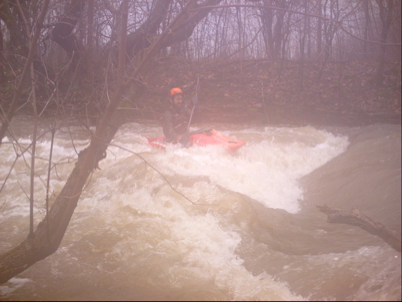
The second private dam is at the downstream edge of a driveway bridge. Approach cautiously back-paddling or on an upstream ferry to one side (probably the right), drifting under the driveway bridge to boat scout how grabby or sticky the reversal below looks.
At high flow (if you have to duck or limbo under the bridge), it tends to 'wash out' into a wave. At moderate flow, it can be a playable (if sometimes a bit 'sticky') hole, with decent eddy service. At lower boatable flow, it will be a sucky pourover. Make certain to paddle THROUGH the boil.
It may be possible to seek permission to use this driveway to leave a shuttle vehicle (somewhere out of their way) to start your run here, avoiding the the two mandatory portages and mostly featureless access paddle down to this point. (I have never intentionally sought contact with the home-owner, nor unintentionally encountered them, so I don't know how boater friendly they may be.)
Width: 10'-15' Length: 200'-300'
Just beyond the pool (below the private dam), the gradient picks up nicely as the creek turns sharply to the right to head toward the Hawthorne Road culverts. This means there is strong current heading toward and through the culvert. Any deadfall or snags upstream, or blocking the culverts, will be very difficult to negotiate or avoid.
There has been total blockage of the stream the past few times I've done this creek. Therefore, it is best to scout this area (as well as you can -- there are no shoulders on the road here to park on) before putting in anywhere upstream. It is likely you'll have to portage (through underbrush and deadfall on shore) to put in upstream (or downstream) of the culverts.
Drainage at this point is up to ~6.8 square miles.
As you pass a small rock outcropping on right bank, you'll see a large tree river-right, likely accumulating dead wood, blocking the right side. If you can get through, you'll drop over the roots of the tree. Don't get too excited thinking the photo shows a great falls to run ... it's a 3' drop. Immediately downstream, there's a smooth-strand fence surrounding a pasture. If flow is not too high, it may be possible to slip under the fence tight to right shore. If passage in boat is impossible, portage is likely to be awkward.
Generally it is not an option to stay to the left (in the main channel), because current is swift, taking you into the (likely electrified) fence spanning the creek. On very rare occasions the bottom strand may be broken out, leaving enough clearance for you to pass, but be very wary and cautious to be certain of your strategy before staying in the main flow here!
Right as you prepare to enter the culverts under Hwy.181/Wauwatosa Road, another triple-wire smooth-strand fence (possibly electrified) will block your way.
Again, portage will be difficult. I have been able to lift the bottom wire (when not electrified!) and squeeze under. More likely, though, you'll be trying to carefully squeeze under or between the strands, push or pull your boat through, cross the (often rather busy) road, and put in on the other side.
At the end of the pasture downstream of the road, you'll encounter a fence (possibly electrified!) and the creek enters a heavily wooded area. Over the years, multitudes of deadfall have blocked the stream causing it to repeatedly seek to find new ways to continue downstream. This splits the already small creek into braided channels.
In the past, I had found best passage by going as far right as conceivably possible before slipping through/under the fence. More recently that seems a total snagfest, and I have gone as far left as possible.
(Because of how frustrated you are likely to be after finding your way through, I like to call this the Disenchanted Forest.)
Width: 25'-30'
After slogging your way through the 'Disenchanted Forest', you'll encounter some bedrock riverbed and some gradient. As mowed lawn appears to the left along a long estate driveway, the sloping bedrock creates a fun little wave. At good flows this has a pretty fair pool/eddy below, and will allow surfs and spins (too shallow for anything vertical). At moderate-to-high flows, it will actually get a bit sticky/retentive!
Drainage has increased to a whopping ~8.5 square miles. Wahoo!
Width: 15'-20' Length: 200'-300'
After passing through a box-culvert (under a driveway), the creek re-enters a wooded area. As you reach a clearing for powerlines overhead, take-out immediately to scout (river-left is probably best). The next stretch of creek slips and slides and bends and twists down some nice bedrock. The rapids are not overly difficult for a reasonably skilled boater, but you cannot see far enough ahead to 'boat scout', and the area is very prone to holding snags and deadfall, sweepers and strainers.
There are no eddies, so once you pass the power-lines, you are pretty much committed to what is going to happen. Any snag or deadfall in here would be serious trouble. So, while the rapids really barely rate class II, and it may seem a hassle to have to get out and scout, failure to do so would represent a serious lack of concern about safety.
(Mostly a 'way point') A box culvert for a private estate.
After the 'slip and slide' and the minor trailing bedrock rapids, the creek heads to the edge of the woods. A massive logjam had blocked passage for years, pushing the water over the banks and through the woods. One had to muddle through (in boat or out) to get to the road. Some years back this was cleared (either by the WIDNR or a fishing group?), but is likely to accumulate wood once again.
If you are able to stay on stream, be wary as you come out of the woods and encounter the railroad. The trestle has very minimal passage, so you may need to break out of current and exit your boat before being flushed under. Just downstream, the bike trail bridge has similar low passage. If either/both are impassible, you may just as well skip the rest of the creek and just carry out to the road via the bike path.
In the rare event that you can paddle through both of those, get out before the Highland Road bridge.
While it could be interesting to paddle to the confluence with the Milwaukee River (just downstream of the Thiensville Dam), the problem is that downstream of Highland Road, all the gradient is spent, and things turn into broad meanders and a totally wooded up mess for half the distance to the river.
Oct 22, 2013
For a reliable boater's gauge, from the upstream-right (NorthWest) edge of bridge deck at the Highland Road take-out, measure down to the water from the lower edge of the bevel. Subtract your measurement from 90' and record that value.
Mar 10, 2009
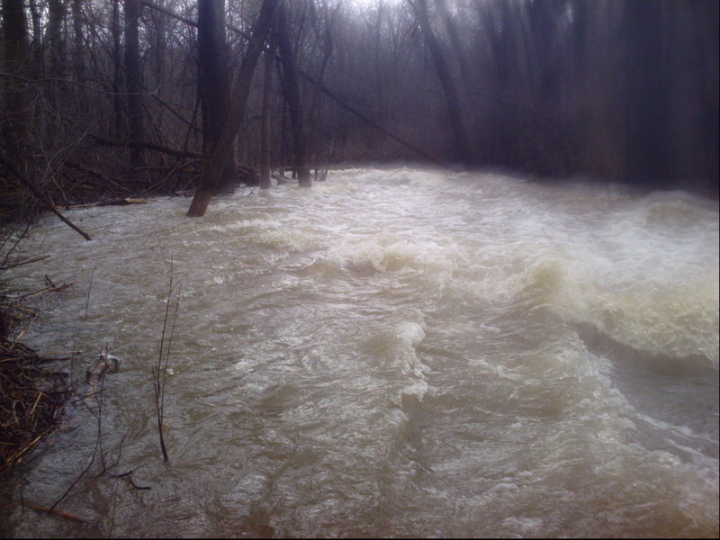
Fascinating. I spent part of my childhood close to Pigeon Creek and once walked its bed from its mouth at the Milwaukee River to its sources above Hawthorne Road, springs in a meadow. as I recall. I knew, still know, stretches of it well from fishing, seining, and spearing in the 1970s and -80s.
In spring 1983, when snow melt had raised the creek to about as high as it ever gets, flooding the neighboring woods and part of downtown Thiensville, I put in a two-man rubber raft at the Highland Road bridge and floated, paddled, and dragged down to the Seminary pond (recently removed). A light snow was falling on a gloomy day, but it was fun. I saw the creek and the woods from a perspective that I had not enjoyed before or since.
Thanks for writing up your ride.