Plum Creek
1319 to Hwy 44 (5.37 miles)
| Difficulty | II(III) |
| Length | 5.4 mi |
| Avg Gradient | 22 fpm |
| Reach Info Last Updated | March 15, 2006 |
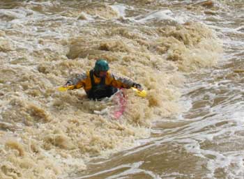
Plum Creek is the best play run for Louisville area boaters. 5 miles with over 50 playspots. Point your bow up stream and catch a wave, if you miss one another will quickly follow. Flowing along the Bullitt and Spencer county line the creek runs only a few days a year. Look for thunderstorms bringing 1.5'+ of rain to the area. Before the rain stops head to the river as the water will not last long.
As far as hazards, it's a narrow stream that is pretty much a flush from top to bottom, with very few eddies, strainers are a possibility. There are 3 bridges on the run and each of these should be approached with caution since the pilings can trap logs pretty easily. Class II-III skills are adequate if you are comfortable reading water on the fly.
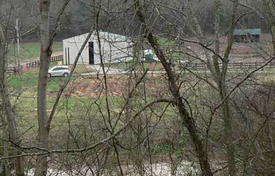
The property owner at the put in asks that paddlers take the gravel drive down the shore line and park at the last barn on the right. Pull into the fenced area outside the barn and park along the fence. DRIVE SLOW ON THE PROPERTY. The property owner has many dogs, and kids. Plus wet ground causes ruts. Obey her rules or donÂt park on her property. On a side note: The stone house is on the National Register of Historic Places.
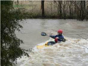
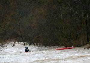
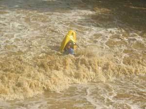
As soon as you put in, you will see some waves popping up on the river left side, shortly after that, you'll come to the 1st ledge. Run this ledge about 15 feet off the river left side to miss the worst of the hole. You can skirt it completely by hugging the left shore. Photo is the first playwave above the ledge.
When the swinging bridge is in sight, be ready for 'The Slide'. At 2.0 feet, it feels like sliding down a sliding board, at 2.5 and higher, it feels like you're on a really fast conveyor belt.
Don't worry, though, there's no hole at the bottom... Left Side is usually deeper.
Another series of surf waves. Be sure to check the bridge below for wood before you surf.
A rapid with a hole on far river left, and far river right. River left flows into several trees and a large tree over hangs river right. Best move is middle left to middle right.
Little Plum Creek adds more water to the creek after the 2nd bridge. A strong hole on the left after the bridge starts another nice series of play waves.
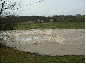
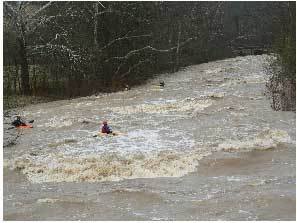
The best wave/hole at medium to high water. Wide, with a huge foam pile. No eddy access but you can walk back up on river right shore. Those not wanting to surf run on far river right or left.
'Buddy's Hole' lies in wait (waiting to put the munch on you) under the 4th car bridge. Eddy out on river right above it and run either right of the bridge support at higher water or left of it the rest of the time and skirt the hole.
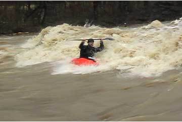
If you're feeling froggy, jump in the hole, although, it may keep you for awhile. A great play wave with eddy service is just below.
Best Play spot with eddy service on the river. Great Park and Play spot if you don't have a shuttle.
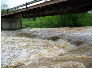
Waterford Park is the takeout on river left before the Hwy 44 bridge. Enjoy the Swingset.
Dec 8, 2007
Best rafting day of my life: Ran Plum at 1 foot as it drained down to 6 inches. Hazard to include: Below KY 155 about a third of a mile is a low water bridge. The 3 foot ledge wasn't runnable on right at such a low level, but we were able to climb up that side to re-run this rapid, which I did 4 times. Left middle was the most fun, and far left is broken in to two ledges with no hydraulic whatsoever. The only bad experience I had was on this 3 foot drop: The main current flushes out in the very middle and creates a very nasty keeper hydraulic that tossed my raft like a raging bull, and I only escaped thanx to my throw-rope and my brother pulling me out. We also encountered a ledge that was very sticky; we fell in the middle and we were only able to escape this hole by eventually making are way to the very left of the creek. Another ledge had a very sticky hole on the middle right. There were tons of eddies at 1 foot, and if your inexperienced this is a great level for you. If you ever get scared just stay to the left EXCEPT for the class III rapid under the forth bridge, run it far right.
-Note- To view the pages below: Copy the URL(http://www.whatever.com) and paste it in your web browser's Address bar, and press Enter. I have invented two different ways of figuring out whether it's runnable. The first is a gauge of a creek named Cedar Creek, a high-water stream (that is, streams that can only be run after exceptionally heavy rains) just like Plum Creek is, and with a similar gradient as Plum (17 FPM average, 35 FPM max). The only difference is that Cedar Creek isn't as wide, and it has a gauge. But since both of these creeks are highwater creeks, with the same gradient, and the gauge is located 10 miles west of Plum Creek; it's a great way to see if Plum is running. The next method is to look at the precipitation gauge at the Ohio river. If 1.4 inches of rain falls in 4.5 hours, plum will be running as long as the same storm that hit downtown by the Ohio has hit Plum Creek, then this method is very accurate I think. Or you can just watch the weather channel to find out how much water has fallen. I think it flashes up super quick at the very bottom during your local on the 8's. This is a picture fully explaining everything using USGS charts and some explanations, and it is to be used as an example to see what it is going to take rain wise to get to run Plum:
http://img127.imageshack.us/img127/949/plum0pl.jpg
Below is the URL to the Cedar Creek gauge and you can check it all the time after every storm and you will soon learn that it is definitely a highwater creek just like Plum. If the creek were 5 or 10 feet wider it would be Plums exact clone as far as the way it fills up and drains water. If this gauge said that Cedar Creek maxed out at 3 feet and it's currently at 1.6 feet, then plum should be at 1 foot(as long as the storm hit both creeks, there only 10 miles apart). It would be even better if you got in Plum when Cedar was at 3 feet of course. I wouldn't recommend running Plum just cause Cedar maxed out at 1.5 feet, because Plum and Cedar would loose that amount of water very quickly. I have found my cedar gauge to only be accurate up to 1 foot, if cedar says one foot then plum should be at half a foot. This has been tested on four different occasions or more, and all of the tests were in my theories favor. Here is the URL address to the Cedar Creek Gauge:
http://waterdata.usgs.gov/ky/nwis/uv?cb\_00065=on&cb\_0006
0=on&format=gif&period=2&site_no=03298250
To find out how much it has rained at Downtown Louisville, use this URL address to the Precipitation in inches gauge, it is at the bottom of the page: http://waterdata.usgs.gov/nwis/uv?cb\_00065=on&cb\_00
045=on&format=gif&period=2&site_no=03294500
UPDATE: Here is a link to tons precipitation gauges all around Louisville:
http://www.msdlouky.org/aboutmsd/rainfall.cfm
If the storm is going from west to east, then TR08 (Fern Creek) plays an important role in finding our if Plum is runnable, especially if the storm is heading north east.
TR07 (Floyds Fork) also plays an important role, if both of these gauges say that there has been a total of 1 inch of rain, Plum might be at a low runnable level, but if they say 1.4 inches, and if it’s wet season, and if all of that rain fell in 4 hours, and the storm is heading in a western direction, then you can bet it’s running. TR15 might also play an important role, I forgot I’ll have to go rummage through my notes and give a more in depth explanation later, and yes I’m serious lol.