Virgin, N. Fork

01. Chamberlain Ranch to Temple of Sinawava (Zion Narrows)

Reach banner
DifficultyIII-IV(V)
Length14.5 mi
Avg Gradient87 fpm
GaugeNorth Fork Virgin River Near Springdale, Ut
Flow Rate as of 14 minutes
43 cfsbelow recommended
Reach Info Last UpdatedApril 12, 2024

River Description

In a May 13 2019 warning, Mark Hodges shared:

There is a New Rock Slide/Class 5 rapid on the narrows. Coordinates 37.3325 - 112.95758. It's a couple hundred yards upstream of Big Spring.  The Rock Slide is on River Right. As you near the area look up and to your right to spot the slide. Be prepared to pull over and Scout/Portage. The portage is easiest on River Left hiking through Campsite 12. It’s the most difficult rapid on the narrows right now. NPS confirmed it is a new slide that occurred winter 2017/2018.

=============

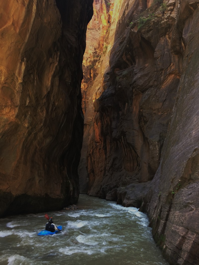
While this 16 mile stretch of river is certainly a class III run at some levels, it is about as committed of a run as you can have, and is not for beginners.  Solid class IV boating skills with a reliable roll, rescue skills are a must.  While at lower water levels, taking a class III boater down the Narrows in a ducky may be appropriate, more skilled boaters should be on the trip to insure safety.

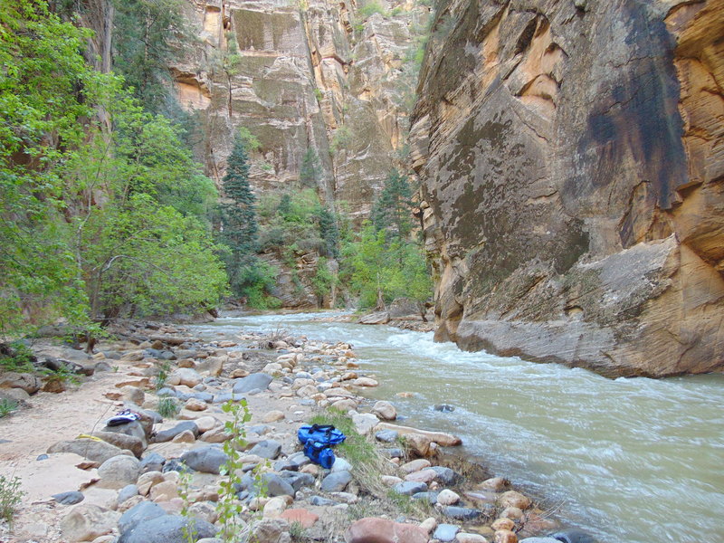
Also, all boaters should be in good enough physical condition to drag/carry their boats for 8 miles down to Deep Creek (see flow info.)  Fatigue can definitely be an issue.  An overnight trip would be one way to allow for this, although the permit office has not always allowed for this, possibly due to flash flood potential.

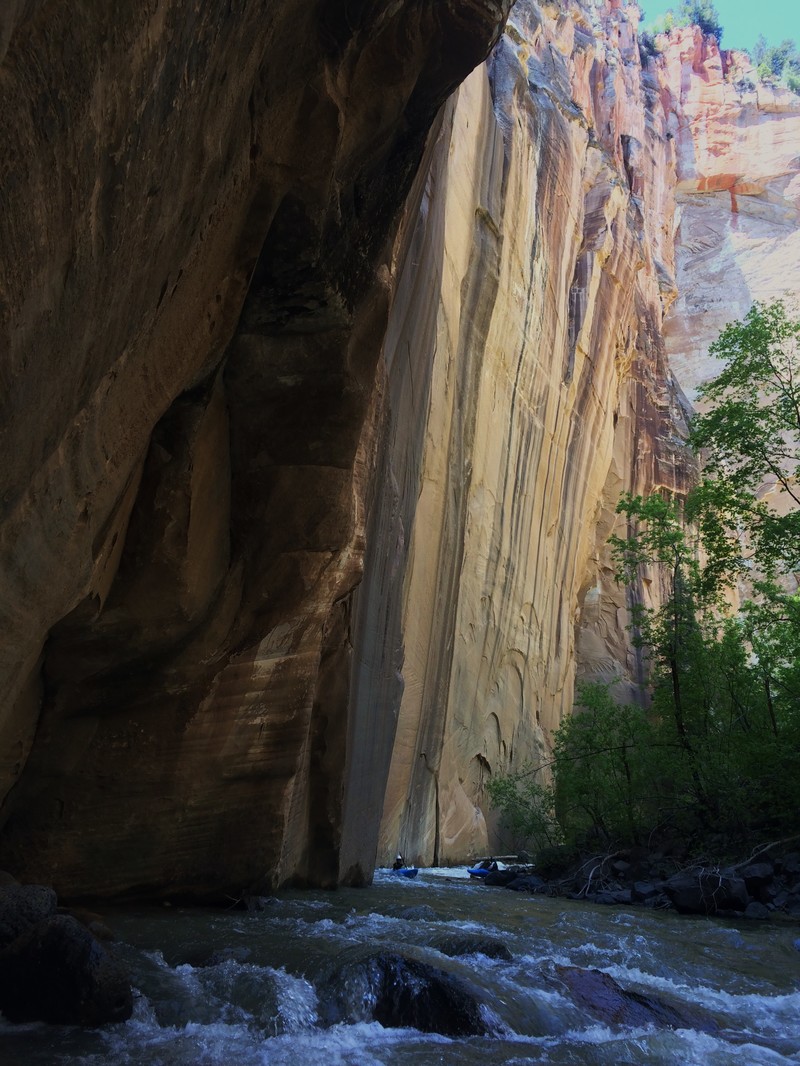
The only way out of the canyon is down.  You'll need a boat for that, unless you want to swim for a couple miles or wait a few weeks for the water to drop.  If you lose your boat, you'll be waiting for Search and Rescue or if your lucky another groupwith a ducky you can jump onto.  This could take 2, 3 or even more days.  Keep the possibility of this happening as low as possible by being completely comfortable any rapids you might confront.  This is not the place to test your boating skills.  DO NOT attempt to hike out of the canyon.  It may look possible from the river, but after the first 2 or so miles, it is not.  Your route will cliff out on you if you attempt

...

River Features

Put In

Distance: 0 mi

Barb wire fence

Distance: 1 mi (approx.)
Portage
Hazard
Barb wire fence

It would be a bad strainer if there was any water.  Portage through the gate on the right, be sure to close it behind you.

Log Jam

Distance: 6 mi (approx.)
Portage
Hazard
Log Jam

River wide log jam.  Definitely a problem if there was for some reason a lot of water.  Be careful while portaging as some of the logs move around and could cause some bad injuries.

15 Footer

Class: IV+Distance: 7 mi (approx.)
Waterfall / Large Drop
15 Footer

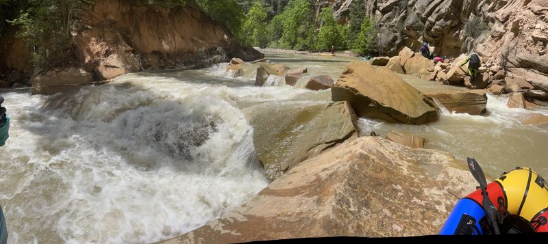
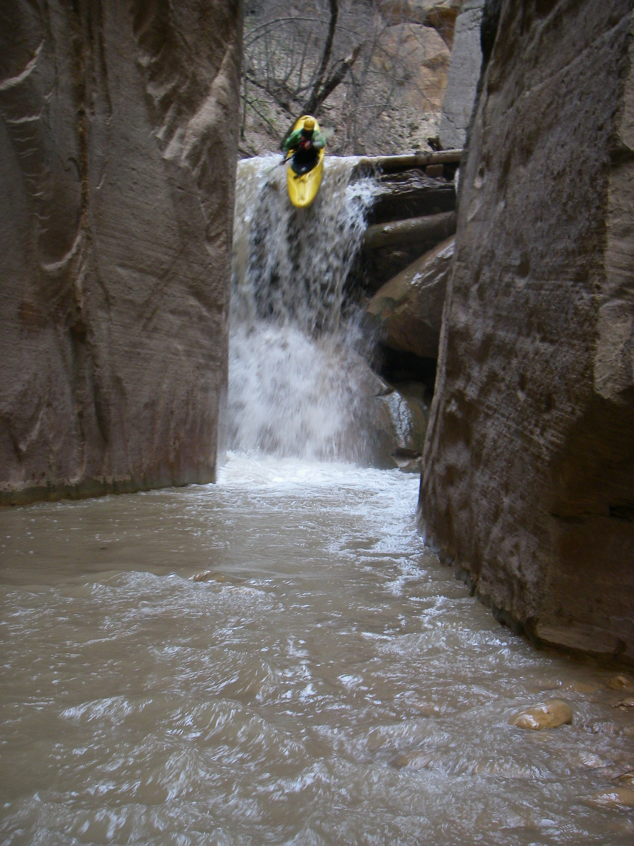
One of the highlights of the run.  A fairly clean 15 foot waterfall into a cool slot.  Some rocks and a small cave could cause issues, but there likely won't be enough water to cause concern.  Do make sure there is enough water to get over the log that forms the lip of the drop.  At low enough flows you could stall out and pencil into the drop.  Avoid penciling in, as the pool is apparently not super deep.  There is a little slot up and to the left of the river that works great for portaging or lapping the waterfall.

Slide to rock

Class: IVDistance: 7.1 mi (approx.)
Hazard
Slide to rock

Look for a horizon line.

5 foot slide directly into a rock.  You should be able to make it by staying far right, where there's not much flow.  Might as well get out and scout, because it would really hurt.

Deep Creek

Distance: 8 mi (approx.)
Rapid
Deep Creek

Celebrate, eat some food, and get ready for the fun part.  Make sure everyone is still feeling confident after the hike in.

Campsite 12

Class: IVDistance: 10 mi (approx.)
Rapid
Campsite 12

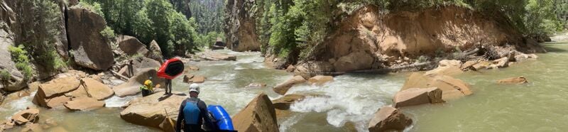
First rapid in a series of boulder garden rapids.  Look for it around a right hand turn.  This one is the steepest, most difficult, and will likely have the most dangerous wood.  Scout river left.

Blind Right

Class: III+Distance: 11.5 mi (approx.)
Portage
Hazard
Blind Right

After one boulder garden rapids, the river should disappear behind wall to the right. Head far left, taking a chute between the wall and a rock that will put you in an eddy with a small beach. Scout the rapid from there. The river sieves out into a log jam, although probably not fast enough to be particularly dangerous. At levels around 500cfs a slot should open up river right of the log jam making the rapid runable.

Careful seal launching below the log jam in a hard boat. The rocks are undercut and could flip you. Consider seal launching off of the large boulder to the right instead.

Orderville Canyon

Distance: 13 mi (approx.)
Rapid
Orderville Canyon

Cool side canyon to check out coming in from the left.  You can paddle up into it to check it out.  From a little before here, and down the rapids should be fairly easy until hitting the concrete path.

Concrete Path

Class: IVDistance: 15 mi (approx.)
Access Point
Concrete Path

4 or 5 drops in a boulder garden, most likely with some significant wood.  Get out and scout as tourists stare and take pictures.  One of the best rapids on the run, and you'll probably have an audience.

Temple of Sinawava

Distance: 16 mi
Take Out
Temple of Sinawava

Cool rock formation on the right.  Takeout on the left.


Had a nice run on 6/7 at 200 CFS with four packrafts.

Parked at Bulloch's Cabin (this will require you to drive across a knee deep Virgin River and a high clearance 4X4 but not a jeep.) It's a 4 hour walk from there to the confluence of the Virgin with  Deep Creek. Perhaps 100 stream crossings ranging from mid shin to mid thigh. While there are places where you could float on the Virgin before Deep Creek, there was never a section where you could have gone even 1/4 of a mile without getting out of your boat. At a higher flow (400 on the gauge?) it woul be doable, but there were a lot of wood obstacles in that section.

From Deep Creek to the end of the Riverside Walk takes just over 2 hours at 200 CFS. We ran the Kolob Creek rapid (went right under the wood), easily portaged the Campsite 10 rapid on the left (although that one was tempting), and portaged the Campsite 12 rapid on the right (not tempting at all, that's a deathtrap). There was another log all the way across the river downstream from Orderville. We tried to get under that on the elft, but two of us flipped on it so the other two chose to either portgage or swim under the right side.

At 200 CFS, it was easy to pull over before hitting any of the big rapids and there was very little buttscooting from Deep Creek to the end of the Riverside Walk. We never had to get out of our boats because the water was too low.

We decided to keep going, originally planning to float to the Court of the Patriarchs, but bailed out at The Grotto and got on the shuttle. It took another hour and a half and several portages around wood (including right after the Riverside Walk) but was markedly slower going than upstream had been.

All in all, at 200 CFS I would call it mostly Class 2 with a little Class 3 assuming you portage the biggest rapids.

At 400 CFS, you could probably put a hardshell in the river right at the main parking area and have a nice trip, saving that 4 hour walk to Deep Creek.

By the way, before dropping the 15 foot waterfall, if so inclined, I recommend you walk all the way around it on the bypass to scout. There was an impassable wood obstruction/strainer below it, just out of site.

There is a new rockfall just below campsite 10/Goose Creek that creates a class 4 rapid, just as the river bends right (37.33809, -112.95566). There's an easy eddy on river left. Portaging right would be tough but doable, with the put-in in swift water. Our kayakers ran the rapid while the packrafters and duckies portaged left (but not all the way left due to a strainer), and plopped down in a 1-boat eddy to resume down-river travel.

JL
Jusbyn Lockard

Dec 23, 2017


Rare beach in the narrows. 1/2 mile below confluence with Deep Creek

JL
Jusbyn Lockard

Dec 23, 2017


Portage around log jam.

JL
Jusbyn Lockard

Dec 23, 2017


Amazing

JL
Jusbyn Lockard

Dec 23, 2017


Narrows below Deep Creek.

JL
Jusbyn Lockard

Dec 23, 2017


Kayaking the narrows. Crazy rock formation on right. Looks like a face!

JL
Jusbyn Lockard

Dec 23, 2017


Campsite 13

PD
Paul Diegel

Jun 1, 2017


Packrafted this 5/15&16/17 at 220-240 cfs. Hiked to Deep Creek which about tripled the flow. Would have been a tough, tough hike with hard boats - in and out of the water, squeezing thru vegetation, slippery, too shallow to float. I'm not sure at what level you could float from the ranch - maybe 400 cfs? The 15 ft waterfall is above Deep Cr and mostly blocked by a river-wide log about 3 ft above the water. Might be runnable with the right flow, but you'd launch while hunched over underneath the log. Easy obvious portage. Pretty easy paddling after Deep Creek with a handful of portages due to river-wide wood. Spent about 8 hours paddling from camp at Kolob Creek to Springdale, including a hike in Orderville and lots of scouting in the mile or so of class 4ish boulder garden near the park entrance. I'd call it a class 2 float at that level, but pretty unforgiving of lost of damaged gear or an injury. Getting out without a boat would be really hard. Logistics: You need a permit, which can be picked up from the backcountry permit office beginning at 7 am. Special floating rules: no hiking if the flow is over 150 cfs, and boating only if the flow has been between 150 and 600 for the last 24 hours. You can start your trip the day you pick up the permit if you are boating. There is good camping between Chamberlain Ranch and the park boundary and at 12 designated sites in the first half of the canyon within the park. It looks like the log jams come and go - be alert. You don't need to select or reserve a campsite. At the flow we had, you could pick up your permit, drive to the take out, hike in, and float the whole thing in a day, I think, but it would be close and rushed at best, and misses some of the point of being there.

BV
Brian Vogt

Jun 28, 2011


Ran the narrows 6/19/2011. Run was in great shape, wood at kolob creek rapid was runnable. no portages necessary. this think is a gem, world class canyons, decent ww in spots, but the I-II sections are better anyway so you can look around. If you go, plan to overnight just in case. it's too great a place to blitz anyway. don't have an epic, and if you do, please self-extricate.