Westfield, W. Branch
1. Becket to Chester
| Difficulty | III-IV |
| Length | 7.9 mi |
| Avg Gradient | 66 fpm |
| Gauge | West Branch Westfield River at Huntington, Ma |
| Flow Rate as of 45 minutes | 25 cfsbelow recommended |
| Reach Info Last Updated | May 30, 2021 |
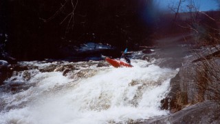
The river is class III boogie water all the way from the put-in to the sixth railroad bridge. After the bridge there’s a short calm stretch where you can gather up the troops. Right after the next left turn is a short class IV rapid which is best run on the far left. After the rapid there’s a short calm stretch then a second class IV rapid ending at the next railroad bridge. Run this one on the far left also.
After the class IV rapids there is a pool where you should take out on the left and walk down to the next drop to scout. Here there is a vertical drop into a hole which is best run on the right edge. At the bottom of the drop Coles Brook enters from the left.
After Coles Brook it’s all boogie water again until the Bancroft Road Bridge which is the end of the upper section and the start of the lower section.
The lower section is easy paddling until Factory Book enters from the left. Below here the river splits. The left channel is usually blocked near the bottom so the right channel is the way to go. This is a short powerful class IV rapid with holes on the right. The rapid changed after Hurricane Irene so the best line now is down the center left. This short section ends with a steep chute in the center then is immediately followed by a class III-IV rapid.
The next rapid is a long, complex class III-IV rapid ending at the next railroad bridge. After the bridge the river is mostly class II-III until you get to a river wide ledge called Double Drop. You can’t see the ledge until you’re committed to the rapid so the best way to know where you are is to observe where the river turns. The ledge is located where the river turns left-right for the second time. Enter the rapid on the extreme left and eddy out in a long eddy on river left just above the ledge. Coming out of the eddy punch through a small hole and run the ledge on the far left.
From here to the take-out the river is mostly class II. The take-out is located on river left j
...After passing under a railroad bridge there will be a large flat rock on river left with an eddy behind it before the river starts to drop. Take out on left here to walk down and scout. The rapid is run down the left side. When you get to the main drop you will be on the far left and drive to the center. You aim for a roostertail that is in the drop. There is then a small pool where Coles Brook enters and the river bends right. As it turns right there is another drop with a hole at the bottom of it. At certain levels the hole is retentive. The easy line is on the right side. There is also a good boof on the left side next to the boulder on the left side.
This is a gorged section with two ledge drops. There is a decent eddy above it to prepare on river right. The first drop is run down center or left. If there is enough water the left line is easiest. The center is a V hole that can be punched. The second drop is run down the left as the hole is very retentive on the right.