Patapsco, South Branch
2. Marriottsville Rd to Patapsco, N. Branch confluence "McKeldin Falls"(McKeldin Falls)
| Difficulty | I-III(IV) |
| Length | 1.3 mi |
| Avg Gradient | 17 fpm |
| Gauge | Patapsco River at Hollofield, Md |
| Flow Rate as of 34 minutes | 37 cfsbelow recommended |
| Reach Info Last Updated | October 26, 2021 |
Note: read below and/or click the Map tab to see the multiple access points for this section.
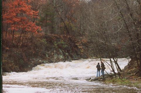
The put in is at Marriottsville Road at the Carroll County-Howard County line. Proceed from here with caution, for just a few hundred yards downstream lies McKeldin Falls, the largest single rapid on the Patapsco River. It's a solid class 4, quadruple-ledge drop that falls a total of about 12 feet over 20 yards. When the hills on river left become high and canyonesque, listen for it, and get out (river left) to scout. The portage is a wickedly steep climb up the hill/cliff on the left, and then around to a large pool at the bottom. For the experienced, a variety of routes can be used depending on water level, but beware of small sieves against either shore, and a very wide, flat, mildly undercut rock (usually submerged and creating a strange looking hydraulic) at the dead center of the river near the bottom. It looks as if it would love to eat the nice flat bow of a playboat.
From here, the river calms again for the next 3/4 mile to the confluence with the N. Branch Patapsco. There is no road access here, so you'd either need to enter the McKeldin area of Patapsco State Park and just run McKeldin Falls or paddle enother 2 miles of mostly flatwater to the takeout at Woodstock Road (steep climb out on the right) to the parking lot across from a roadside bar. Don't miss this high overpass: Daniel's Dam is the next best takeout, after a further five miles (of mostly flat water) downstream.
If you'd like to run just the McKeldin Falls, for a charge of $2.00 weekdays or $3.00 weekends, you can enter the McKeldin area of Patapsco State Park and follow the signs to the McKeldin Falls parking area to park and have a short carry directly to the Falls.
BTW: McKeldin Falls was created sometime between 1830 (when the B&O Railroad was started) and 1851 (when Howard County was created from a portion of Anne Arundel County) when the B&O railroad decided
...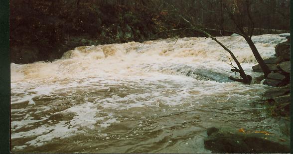
McKeldin Falls is the largest single rapid on the Patapsco River. It's a solid class 4, quadruple ledge drop that falls a total of about 12 feet over 20 yards. When the hills on river left become high and canyonesque, listen for it, and get out (river left) to scout. The portage is a wickedly steep climb up the hill/cliff on the left, and then around to a large pool at the bottom. For the experienced, a variety of routes can be used depending on water level, but beware of small sieves against either shore, and a very wide, flat, mildly undercut rock (usually submerged and creating a strange looking hydraulic) at the dead center of the river near the bottom. It looks as if it would love to eat the nice flat bow of a playboat.
Lat/longitude coords are approximate, from online maps.
Jun 7, 2017
I've split the Gaither Gorge section from the McKendin Falls section, so some of the following comments may refer to the other Patapsco, S. Branch section.
Jun 1, 2015
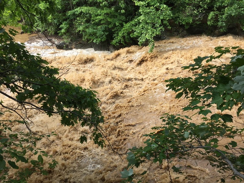
Over 1200 CFS in the South Branch of the Patapsco makes for a beefy level. 6/1/15
Mar 18, 2015
For a minimum level, look at three gauges: Hollofield 500 cfs; Cedarhurst 150 cfs; Unity 90 cfs. Hollofield is well downstream on the Patapsco Mainstem, so it can still be up when water's drained out of the S. Br. Patapsco, but it is a good reflection of the watershed as a whole; Cedarhurst and Unity are on parallel watersheds about the same amount upstream, so they can give some idea of 'top of the watershed' conditions. Because the S.Br. Patapsco is so flashy, you need to be aware that water can run out from the night before to the morning of the run. I don't know what a maximum level might be, but I would suggest that you go to the downtown Sykesville bridge and look at the river. If your reaction is FUN!, run it; if your reaction is 'Oh My God' it's too high.