One of the most significant outdoor recreation areas close to metropolitan Seattle is the Middle Fork of the Snoqualmie River. Less than an hour drive from downtown, the valley is accessible to a population of over three million people and attracts visitors from across the country. Few places in the country can boast such an incredible resource that is so accessible. The river feels remote as it winds through a forested river valley largely in public ownership, and it was designated as Wild and Scenic River in 2014. A diversity of recreational opportunities are pursued within the boundaries of the watershed.
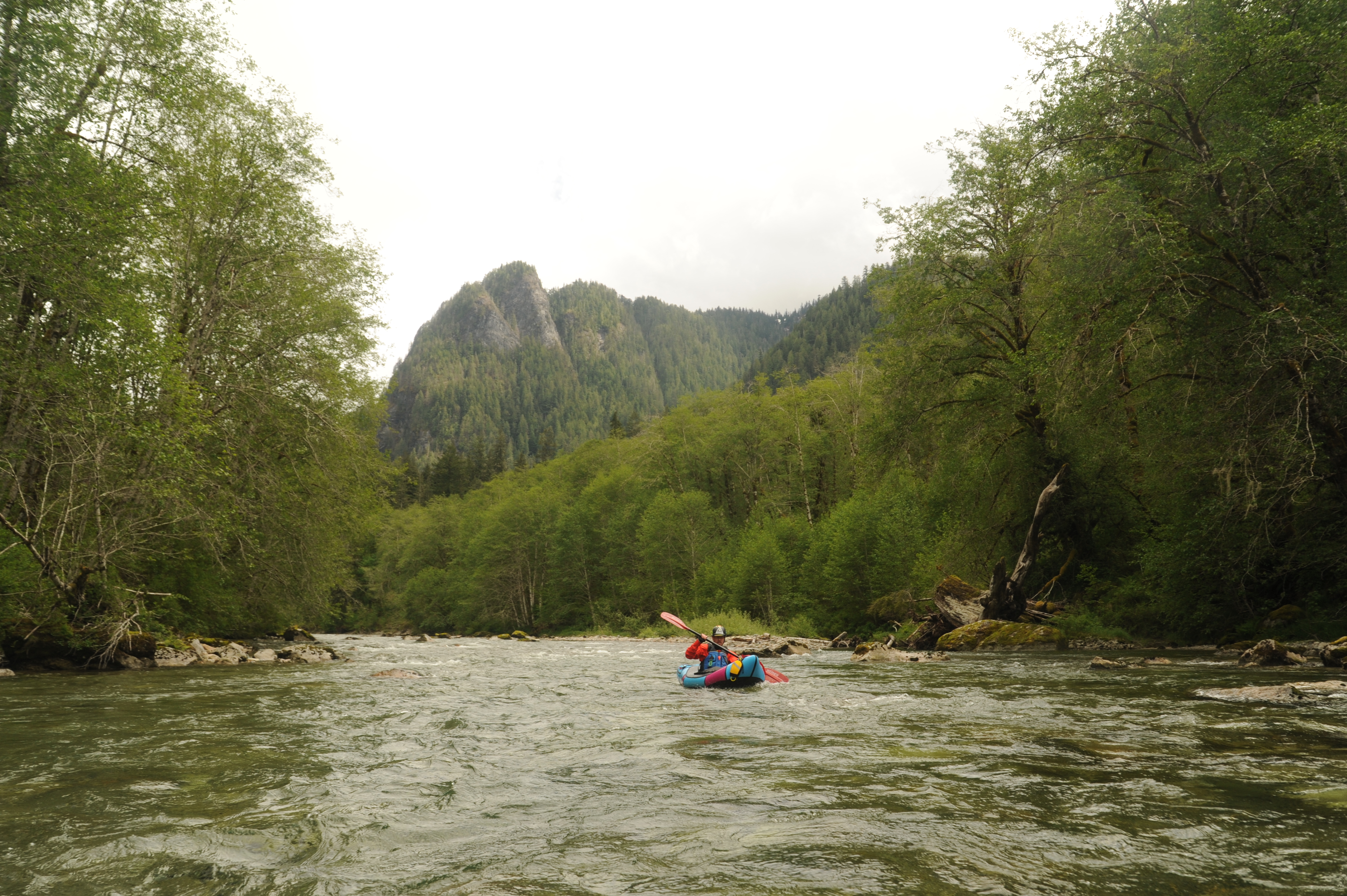
The Snoqualmie River itself is popular for whitewater recreation and provides the closest intermediate whitewater to the greater Seattle area. With over 40 miles of whitewater, the river and its tributaries serve a wide range of skill levels with some sections suitable for beginners and others that challenge the nation’s top experts. The best known section is called the “Middle-Middle” that extends from the Dorothy Lake Road bridge downstream to an access point off SE Tanner Road in North Bend.
For local paddlers, the 7.6 mile Middle-Middle run is a popular “escape” that can be paddled on weekday evenings particularly during late spring when the river is fed by snowmelt from the Western Cascades. The river is also popular throughout the rainy season when winter storms provide ample flows for whitewater boating. In addition to many of the region’s paddlers who consider this river their local run, the Middle-Middle attracts paddlers from across the country who come to sample the region’s rich outdoor recreational resources.
Conservation of the Middle Fork Snoqualmie
American Whitewater has served in a leadership capacity on various conservation campaigns for the Middle Fork Snoqualmie River. We remain actively engaged in management of the river corridor to protect natural features while enhancing opportunities for the public to enjoy the river.
Middle Fork Snoqualmie Natural Resources Conservation Area
American Whitewater was a leader in the effort to designate the the Middle Fork Snoqualmie Natural Resources Conservation Area (NRCA) in 2011 with the transfer of 9,000 acres from Washington Department of Natural Resources state trust lands (used to generate revenue from timber harvest) into conservation status. The NRCA abuts Mount Si NRCA to create a large forested landscape from the City of North Bend to Mount Baker Snoqualmie National Forest— extending from 800 feet elevation at the Middle Fork Snoqualmie River to 5,000 feet. This conservation landscape protects forests and wildlife habitat while providing opportunities for recreation that include whitewater paddling. American Whitewater served on the planning committee for the Snoqualmie Corridor Recreation Plan published in 2015 that covers this landscape and the recreational opportunities it provides.
Wild and Scenic River Designation
In 2014 the Middle Fork Snoqualmie and Pratt Rivers were designated Wild and Scenic by Public Law No: 113-291, Section 3060 as follows:
-
Middle Fork Snoqualmie: The 27.4-mile segment from the headwaters of the Middle Fork Snoqualmie River near La Bohn Gap in NE 1/4 sec. 20, T. 24 N., R. 13 E., to the northern boundary of sec. 11, T. 23 N., R. 9 E., to be administered by the Secretary of Agriculture.
-
Pratt River: The entirety of the Pratt River in the State of Washington, located in the Mount Baker-Snoqualmie National Forest, to be administered by the Secretary of Agriculture as a wild river.
Through the advocacy of the Rivers Council of Washington, a 1990 study by the Forest Service determined the Middle Fork Snoqualmie and its major tributaries were eligible and recommended them to Congress for Wild and Scenic designation. In partnership with the regional conservation community, American Whitewater led the effort to include these rivers in a conservation bill initially introduced by Congressman Dave Reichert in the House followed by Senator Patty Murray in the Senate. American Whitewater was invited to testify on the bill before the House Natural Resources Committee. The Taylor River has also been recommended for designation by the Forest Service and we hope to designate it as a Wild and Scenic River in a future legislative campaign.
Mountains to Sound Greenway National Heritage Area
After several years of effort with our partners, including Mountains to Sound Greenway, we were successful in securing designation of the Mountains to Sound Greenway National Heritage Area in 2019 by Public Law 116-9, Section 6001 (3). The Mountains to Sound Greenway extends from the Seattle waterfront to Kittitas County and the Middle Fork Snoqualmie River valley is at the heart of this landscape. National Heritage Areas are places designated by Congress where historic, cultural, and natural resources combine to form cohesive, nationally important landscapes. The management plan serves as a cooperative framework for management of the landscape across jurisdictions that includes various organizations such as American Whitewater who was invited to serve on the advisory committee.
Access to the Middle Fork Snoqualmie River
American Whitewater has worked for many years to enhance public access to the Middle Fork Snoqualmie River through a series of projects. In 2004, American Whitewater partnered with the National Park Service Rivers and Trails Conservation Assistance program and a landscape design studio class at the University of Washington School of Architecture to develop concepts for improving public access along the Middle Fork. Guided by that plan, several projects have been implemented over the years, including the following:
Bridgeview Access: This Forest Service–administered access is located immediately downstream of the Gateway Bridge on the Middle Fork Trail. For many years, unmanaged dispersed camping in this corridor created conflicts with river access and contributed to significant riparian impacts. The Forest Service took steps to address these issues through a dispersed camping closure in 2025 that includes portions of Forest Road 56 and 5640 under the Wild and Scenic River designation, responding to documented problems such as litter, unburied human waste, damaged trees, and degraded riparian areas. While this action is intended to reduce impacts, its effectiveness will depend on enforcement and visitor compliance. Parking at Bridgeview also remains inadequate; when the road was paved in 2017, Federal Highways did not implement the environmental review’s recommended parking improvements, leaving a longstanding access challenge that still needs to be addressed.
Russian Butte View: This access point is administered by Washington State DNR. The river mellows downstream of this point, making it a popular take-out for those seeking a shorter or less technical day on the Upper Middle. American Whitewater was directly involved in the site design, including revegetation and development of a formalized trail and river viewing area. Continued coordination with DNR will help ensure long-term access. American Whitewater also worked with Federal Highways to ensure the site was recognized and that a pull-out and unloading zone were delineated during the 2017 road paving project.
Granite Creek Access: The Forest Road along the Middle Fork crosses the river at the Concrete Bridge, marking the start of this section. American Whitewater supported King County’s acquisition of this formerly private site and led efforts to formalize public access on the downstream river-left side of the bridge. Our local affiliate club Washington Recreational River Runners participated in volunteer events to formalize this river access site. We also worked with Federal Highways during the 2017 road paving project to ensure the site was recognized and that a pull-out and unloading zone were included.
Mine Creek Access: This site, administered by Washington DNR, once required boaters to scramble through brush to reach the river. The old abandoned campground was a major focus of University of Washington landscape architecture students, who developed several concepts for the site. Over several years, their vision for a vibrant, day-use-friendly site has been realized. American Whitewater worked with the state to formalize the site, constructing a short trail and bridge across Mine Creek to access a beach and pool where paddlers can stage and wait for their group. We also coordinated volunteer events with the local boating community to enhance the site, focusing on trail construction. Advocacy by American Whitewater led to the installation of a toilet, further improving amenities for visitors. The site has become a popular local swimming hole, and the trails we constructed are frequently used for short strolls or dog walking. The result is a site that serves a wide diversity of users well beyond the whitewater community. During the 2017 Middle Fork Road paving project, American Whitewater worked with Federal Highways to formalize parking along the road; this was not included in the original plan, and its addition ensured continued access. Mine Creek remains the most popular access for short after-work runs and becomes a swimming and water play area in late summer.
Tanner Road: A new housing development threatened the future of this take-out on the standard Middle-Middle run, with original plans placing homes fronting Tanner Road. American Whitewater and local volunteers from the Washington Kayak Club worked with the city during the permitting process to require formal parking along Tanner Road. The resulting plan situates homes facing away from Tanner Road and includes designated parking spots adjacent to the take-out along an old county bridge right-of-way.
Blue Hole: The Blue Hole Rapid and its downstream pool are highlights of this run. Historically, the area was also a popular swimming hole and informal access point. Use eventually grew to levels intolerable to nearby property owners. King County owns a parcel at the pool, but access from 114th Street requires walking along the levee on river left, which crosses a narrow strip of private property. Despite signage installed by local property owners indicating that parking is not allowed along the street, parking and river access at the street end are legal, though walking downstream on the levee is not. Boaters wishing to take out here can run the rapid, walk up the midstream island, and ferry across the top of the rapid to reach the legal shoreline access at the street end.
Three Forks Natural Area: A popular access point is located on the upstream river-right side of the 428th Ave SE Bridge in the Three Forks Natural Area. This was once a historic bridge crossing. When the bridge was removed American Whitewater worked to advocate for parking along the old bridge alignment, and a trail leading down to the river.