The USGS warns that the most popular streamgage in Idaho may be cut. This streamgage is on the Middle Fork of the Salmon. While the station is officially identified as USGS 13309220 MF SALMON RIVER AT MF LODGE NR YELLOW PINE ID, boaters simply know it as the Middle Fork Gauge at Middle Fork Lodge.
Even though the streamgage is referenced by thousands of boaters and visitors to Idaho every year, the gauge may be terminated. The USGS has posted an alert on its website at http://waterdata.usgs.gov/id/nwis/uv?13309220 with the terse explanation that “FUNDING MAY BE LOST AND THIS GAGING STATION OPERATION DISCONTINUED Oct. 1, 2004”.
This streamgage is of vital importance for purposes of safety, tourism, and recreational fishing and boating; and there is no more important gauge for whitewater in all of Idaho. Loss of access to real-time streamgaging information on the Middle Fork Salmon would negatively impact tourism, visitation, safety and recreation opportunities.
What is the problem? Tom Brenan, Surface Water Unit Chief at the USGS in Idaho, explained to me that the USFS provides $11,340 each year, the Idaho Department of Water Resources $3,970, and USGS provides a matching amount $3,970 under their cooperative program for the Middle Fork gauge. The problem is that the Forest Service is terminating it’s share of the payment, which has traditionally come from their Boise Adjudication Team. This team works on water rights litigation issues on the Salmon River. The team’s Bob Kenworthy explained to me that the Adjudication Team no longer needs the data for their work and has no more funds available for supporting the site. However, the river is managed by the Forest Service’s Middle Fork Ranger District, thus the agency continues to have an active interest in access to gaging data. The District’s River Ranger, Sherri Hughes, described how she simply does not have the funds available in her budget for FY ’05, and that her program was also making contingency plans for the termination of Fee Demo funding and loss of some additional discretionary funding in ’05.
Ready access to realtime gaging information in the deadly whitewater spring of 2003 revealed the importance of this gauge to rafters, boaters, fishermen, and other visitors when the Middle Fork Salmon rose first to 6.6 feet on May 25th and to 8 feet on May 30th with an incredible flow of 13000 cubic feet per second (CFS). The sudden increase in streamflow resulted in catastrophe when two men in two different groups drowned upon hitting a submerged log on the Middle Fork Salmon near Marsh Creek. The fact that more people did not run into trouble was due largely to awareness of the sudden increase in water level and widespread access to real-time streamgaging data. Further, the access to this information allowed hundreds of visitors to reschedule their vacations to Idaho and to plan on visiting other regional rivers. For more information, see AW’s Middle Fork Salmon River Page at http://www.americanwhitewater.org/rivers/id/618/ and AW’s streamgage page at http://www.americanwhitewater.org/gauges/id/5040/.
Since the station is operated by the USGS in cooperation with U.S. Forest Service and Idaho Department of Water Resources, it is natural to look to these agencies for help in protecting the streamgage. If you are concerned about the possible loss of this gauge, then you must send an email or call the following individuals.
CONTACTS
USFS Director of Recreation Liz Close, Region 4
Fax: 801 625-5170
Email: Lclose@fs.fed.us
Governor Dirk Kempthorne
Office of the Governor
700 West Jefferson, 2nd Floor
PO Box 83720
Boise, Idaho 83720-0034
USGS District Chief Kathy Peter
230 Collins Rd.
Boise, ID 83702-4520
Telephone: (208) 387-1300
Fax: (208) 387-1372Email: dc_id@usgs.gov
ID Department of Water Resources Rob Spofford
Email: rspoffor@idwr.state.id.us
SAMPLE LETTER
(please take a few moments to adapt this letter to reflect your experiences and interests).
Dear Governor Kempthorne,
I am writing to you on behalf of American Whitewater and the nation’s paddling community.
The USGS has recently announced that it will be terminating the real-time streamgage on Idaho’s Middle Fork Salmon River. This station is officially identified by the USGS as “USGS 13309220 MF SALMON RIVER AT MF LODGE NR YELLOW PINE ID”; boaters simply refer to it as the Middle Fork Gauge at Middle Fork Lodge.
The agency has explained that the gauge is being cut due to a lack of funding from the United States Forest Service. Though the Forest Service provided funding over the past several years through the Boise Adjudication Team, the team’s project is concluding and they no longer need access to the data. In 2004, the USFS provided $11,340, the Idaho Department of Water Resources $3,970, and USGS provided a matching amount $3,970 under their cooperative program.
Continued funding and maintenance of this streamgage is of vital importance for purposes of safety, tourism, and recreational fishing and boating. There is simply no more important gauge for whitewater recreation in all of Idaho. Loss of access to real-time streamgaging information on the Middle Fork Salmon will negatively impact tourism, visitation, commercial outfitting, public safety, and recreational whitewater and fishing opportunities.
All is not lost, please work with the partner agencies, Idaho’s Department of Tourism, and Idaho’s Department of Water Resources to look for creative sources of funding to ensure that the gauge is protected in ’05 and into the future.
Please contact me at American Whitewater, 1424 Fenwick Lane, Silver Spring, MD 20910, Jason@awa.org, or 301-589-9453 if you have any questions or if I may be of assistance.
Sincerely,
{Signed}
Jason D. Robertson
National Policy Director, American Whitewater
MORE INFORMATION
How To Save a Streamgage: http://www.americanwhitewater.org/archive/article/680/
AW’s Middle Fork Salmon Streamgage: http://www.americanwhitewater.org/gauges/id/5040/
AW’s Middle Fork Salmon River Page: http://www.americanwhitewater.org/rivers/id/618/
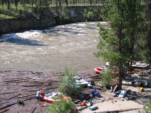
Photograph used in article by Chris Kirkman at 8.5 feet: https://images.americanwhitewater.org/photo/5210.jpg