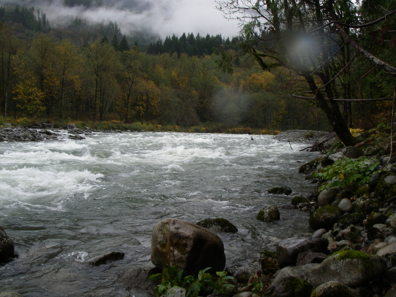
Skykomish
2 - Railroad Bridge to Big Eddy

| Difficulty | II |
| Length | 3.5 mi |
| Avg Gradient | n/a |
| Gauge | Skykomish River Near Gold Bar, Wa |
| Flow Rate as of 29 minutes | 745 cfsbelow recommended |
| Reach Info Last Updated | March 4, 2026 |
This run can be paddled as a continuation of the main Skykomish run and that option is popular with rafters or those who do not wish to hike up the hill at the railroad bridge. Another popular option for those who want some additional class III is to put in right below Boulder Drop and just do the second half of the main run--this option is commonly referred to as Boulder Run.
For many, however, the railroad bridge is the start of a good beginner kayak run popular with locals who have done a couple Powerhouse trips on the Snoqualmie or the Yo-Yo section of the Green, or those who simply just want a mellow float down the river with a few nice rapids.
The most challenging part of this run can be working your way down the muddy slope at the railroad bridge. Put in wherever you like along river left taking in as much of Railroad Bridge rapid as you like. Everything you'll encounter downstream will be a bit easier than this rapid.
The next rapid downstream is Fisherman's and depending on levels this will be a bit of a boulder garden or a wave train that pushes class III. You should be able to boat scout your way through although first-time beginners might want to pull out for a look on the left.
The river continues with some more fun class II rapids that are great for practice and instruction, and in about a mile and a half you'll encounter Proctor Creek rapid which is the second rapid on this stretch to push class III. Most should be able to boat scout or follow the lead of a more experienced paddler. The run continues with a few more class II rapids before the last one that ends right at the Highway 2 bridge (you'll be able to see this rapid on your drive to the river if you look towards the
...![Split Rock - Put In [private]](https://images.americanwhitewater.org/photo/medium/bCFjHsxD5Ue0dGoz38fCK.jpg)
This access point on river left has been used by the paddling community for the past several years but is privately owned. Park within the highway right-of-way on the south side of Highway 2. The small pull-out with the trail to the river should only be used for loading and unloading. If Outdoor Adventure Center is using the site for a commercial trip, please be courteous and stay out of the way. Outdoor Adventure Center has managed the access on behalf of the private landowner who has a few expectations that include the following:
\* take the shortest path to the water and avoid walking upstream to access the Split Rock feature by land (access to river features should be by water and paddlers must avoid creating new social trails along the bank and avoid approaching the private residence),
\* refrain from using Split Rock as a bathroom,
\* consider using Big Eddy as a meeting point for trips where a bathroom and parking is available to consolidate vehicles,
\* avoid bringing dogs onto the property,
\* avoid lingering (exit the river, run shuttle, load boats, and depart the area as quickly as reasonably possible) to avoid the appearance of this being a public river access or picnic site,
\* respect commercial outfitter operations during the summer rafting season when Outdoor Adventure Center is actively using the site,
\* do not use the access site for commercial activity (e.g. paid kayak instruction),
\* fill out a liability waiver with Outdoor Adventure Center on an annual basis.
![Railroad Bridge - Access [private]](https://images.americanwhitewater.org/photo/medium/OzFqGNfdpFpN0IO7MBwEP.jpg)
The access at the railroad bridge is privately owned by BNSF but has been used as an access on river left. It's a short steep climb down under the left bridge abutment from a pull out along the highway. It is located at Highway 2 mile 32.5.

This is the most challenging rapid on the run with a series of small waves and rocks to navigate.

This rapid is just upstream of the confluence with Proctor Creek. Some small boulders are on the left side of the channel. You can navigate through on center right.
![Big Eddy - Take Out [Washington State Parks]](https://images.americanwhitewater.org/photo/medium/Hbhm6r0Dq5WLIaW4akIhD.jpg)
The take-out is on river left at the Big Eddy recreation site at Highway 2 mile 30.4. It is just east of the Highway 2 bridge across the river and on the downstream river left side of the bridge. This access is managed by Washington State Parks and requires a Discover Pass.
Apr 24, 2015
Rafted this route on April 20th 2015, continuing down to the Sultan
River confluence (~another 8 miles of mellower but really pretty Class I water, described http://www.americanwhitewater.org/content/River/view/river-detail/2210/). Flow was 2950. We did the trip by packraft. Once we
were in the water (e.g., not counting the setup time), the trip took 3.5 hours for the ~10 miles,
with us paddling most of the time (we needed to make it to Sultan in time to get one of our party
to the airport). This section itself only took some 40-45 minutes to complete. =====
For the put-in, we parked at the highway pullout next to the railway bridge, just as described here. This
was a Monday, so we were the only car there. It was a sunny day, so the walk down to the river
was not muddy at all, and no problem with the super-portable packrafts. For takeout, since we wanted to raft all the way to Sultan, we left a car there at a parking lot that required the Discover Pass (though, note that we did not see a place to purchase one, if we hadn't had ours). For those who want to take out at Big Eddy, which is the official stop of this route, there is a fee box (and I think it was also Discover Pass) ===== The first 2.5 miles (the section of river described here) was good fun, lots of class II rapids that soaked us when splashing us, but did not seem to be much risk for overturning the packrafts (not sure about a kayak -- packrafts are generally much more stable).
While we didn't necessarily *want* to swim, there were no fallen trees or log jams anywhere, so
even if we had overturned, it didn't look too dangerous.===== From Big Eddy, the river mellowed. The views of
the mountains were excellent, and the river flows through a remote section that only comes towards
the road and civilization near Gold Bar and Sultan. See my trip report at http://www.americanwhitewater.org/content/River/view/river-detail/2210/ for more information on that section.