Underwood Creek
*2025.07.11 WOOD ALERT* Krueger Park to Hoyt Park (0.5 - 3.5 miles)
| Difficulty | II(III) |
| Length | 3.6 mi |
| Avg Gradient | 17 fpm |
| Gauge | Underwood Creek at Wauwatosa, Wi |
| Flow Rate as of 40 minutes | 2 cfsbelow recommended |
| Reach Info Last Updated | July 13, 2025 |
MMSD 'remediation projects' have greatly diminished this once very fun run. They've removed cement channel, laid back the banks, meandered the streambed, and emplaced erratic boulders ( totally out of character with anything which exists in any natural stream in S.E.Wisconsin!) in what they consider to be 'restoring' the river.
A half-mile (from under the expressway at Mayfair Road to nearly the confluence with the Menomonee) was 'restored' December 2017, and the prior half-mile was completed a few years earlier.
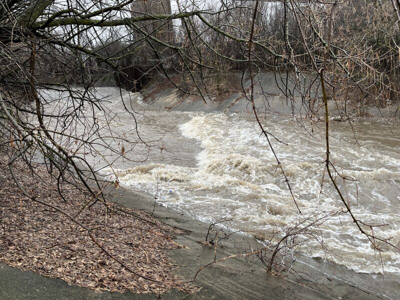
At this time, only the half-mile stretch from 115th Street to Mayfair Road contains ledge/drops (just 1-2 feet in height). The rest of the run is flatwater in a cement ditch, swiftwater in man-made meanders, and 'splishy-splash' class II (at moderate-to-high flows) or rock-dodging/rock-bashing (at low-to-moderate flows) in the lower remediated section.
The 'remediation' has made it take much higher flows to make this run even worth considering, and has made this section far more dangerous for anyone who flips or is out of their boat! DO NOT ATTMEPT TO STAND UP OR WALK IN THE STREAM AT ANY ELEVATED FLOWS . DO AN INTERNET SEARCH TO LEARN ABOUT THE DANGERS OF 'FOOT ENTRAPMENT'!
Quick Facts:
Location: Elm Grove/Wauwatosa
Shuttle Length: 4.4 miles (or 5.6 miles to the take-out for the MenWesTosa run, or 8.15 miles to the take-out of the MenTosa run).
Character: VERY flashy city run; Cement ditch with ledge-drops (diminished as indicated above) for first half, 'restored' meanders and boulder-dodge (piton-hell/'broach-city') in the later going.
Drainage area at gauge (midway on run): 18 square miles.
Put-in elevation is approximately 720'.
Take-out elevation is approximately 660'.
Thus total elevation change is approximately 60'.
NO
...vvvvvvvvvvvvvvvvvvvvvvvvvvvvvvvvvvvvvvvvvvvvvvvvvvvvvvvvvvvvvvvvvvvvvvvvvvvvvvvvvvvvvvvvvvvvvvvvvvvvvvvvvvvvvvvvvvvvvvvvvvvvvvvvvvvvvvvvvvvvvvvvvvvvvvvvvvvvvvv
If the descriptions (in the main write-up and elsewhere) are not enough to dissuade you from considering this run, you might wish to be further informed . . .
The following quotes (with personal bold/italic emphasis added) are from an article (in the Shepherd Express, a local 'alternative' newsweekly) entitled 'Going with the Flow -- How the suburbs are helping close the beaches':
'Tests during rainfalls ... at 15 sites along waterways in Milwaukee County regularly show Ecoli and fecal coliform amounts are thousands of times higher than the EPA standards for beach closings ...'
'... numbers this high are comparable to untreated sewage.'
'One study found ... about 15% of fecal coliform found in stormwater runoff is from dogs.' (I.E., people who do not pick up after their pets!)
' The highest concentrations of E.coli and fecal coliform have been found in Underwood Creek in Wauwatosa and in the Little Menomonee River'
'people can get sick from water like that, but the illness may be passed off as something else since it isn't that severe.'
So . . . take all that for what you wish to make of it!
^^^^^^^^^^^^^^^^^^^^^^^^^^^^^^^^^^^^^^^^^^^^^^^^^^^^^^^^^^^^^^^^^^^^^^^^^^^^^^^^^^^^^^^^^^^^^^^^^^^^^^^^^^^^^^^^^^^^^^^^^^^^^^^^^^^^^^^^^^^^^^^^^^^^^^^^^^^^^^^
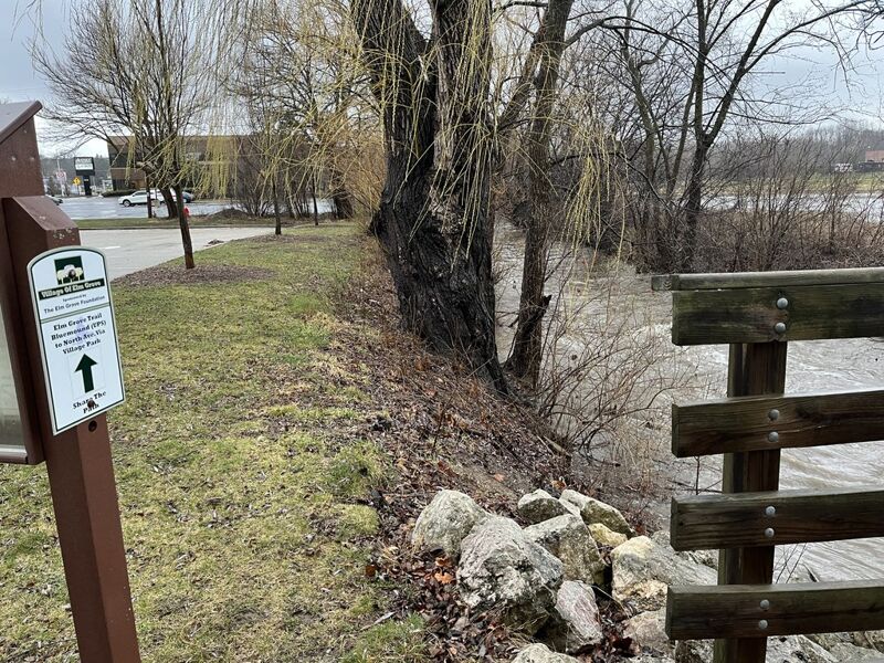
One choice for put-in is from Krueger Park (in Brookfield).
At the northeast corner of the parking lot, a fenced enclosure normally houses a portajohn (handy for pre-run relief).
An improved path to the east leads to the creek.
Walk ~230 yards on the paved path (due east from the parking area) to a footbridge. Carry under the footbridge, get into you boat, and slide down the side of the cement ditch.
Some maps label this Deer Creek, while others label it S.Br.Underwood Creek.
Drainage area here is less than 5.5 square miles. Do not panic too much if flow seems a bit 'thin' here -- less than a half-mile downstream flow may nearly triple.
NOTE: Use coordinates of the parking lot in Krueger Park for routing/mapping apps.
If you use coordinates of this actual put-in, most apps route you to the other side of the river, to a dead-end street without the facilities available at Krueger Park.
An alternate put-in is available on the other branch of Underwood Creek (or what I think is more properly Deer Creek). Traveling west on Bluemound Road, just west of Underwood Creek Parkway, you pass (in quick succession) the driveway to Aurora Health Care Ventures and the UPS Customer Center, then the driveway for a single home. Immediately west of that house, turn right to enter a small (easy-to-miss) public parking lot.
There are two driveways for the lot, but they are marked as one-way, the first/east driveway being the entrance, the second/west driveway being marked with a 'Do Not Enter' sign (I.E., exit-only). Park in the northeast corner of the small lot by a small bridge over the creek.
Put-in is possible from the parking lot side of the creek, but that streambank is rocky and is a bit awkward for putting in. If you walk across the bridge, the streambank is somewhat more gradual and has no rocks, thus may be a better choice.
The upsides of using this access:
A) It shortens the shuttle (minimally) and eliminates the slightly confusing left-turn lane off from Bluemound Road onto Elm Grove Road, as well as the next easy-to-miss final turn onto Golf Parkway through the residential neighborhood to get to Krueger Park.
B) The shuttle can be very straight-forward: Bluemound Road all the way! (Though mapping apps will generally pick other routes which may be a minute or two faster, but involve many more turns.)
C) You'll have super-short carry to put-in (as opposed to ~230 yards carry to put-in from Krueger Park).
D) It cuts off just under a half-mile of flat/flowing water (running 0.08 mile of this trib instead).
E) This starts with a bang (ok, maybe just a cap-gun 'pop'), as it rushes through culverts then bumps-and-thumps down a brief rock-rubble rapids.
The downsides of using this access:
A) It has no 'facilities' (like the 'semi-private' screen/fence and the portajohn which is normally available at our listed put-in)
B) It is on a busy street so has higher 'visibility' (if you need to change clothing or otherwise dally before putting on or upon returning to pick up your shuttle vehicle). (That said, while there is plenty of traffic on W.Bluemound Road / Hwy.18, I have seldom seen any cars actually using this lot.)
C) The culverts under the road/driveway may be partially or totally blocked by debris, making an awkward situation to have to deal with, and the brief rocky stretch may be a bit of boat and paddle abuse.
The culverts under the driveway to the UPS distribution center (and a building with a couple other businesses) divide the flow of this branch/creek. Wood may block some parts of these, so approach with caution if you've opted for the put-in from this branch/creek.
I like to intentionally mispronounce UPS to call this 'Ooops Rips', since the rocky rubble (from the outlet of the culverts to the confluence with the cement ditch) is likely to be a bit bony, resulting in multiple contacts with rock, deflecting your boat and paddle strokes, and messing with your line down this stretch.
Immediately after you pass under Bluemound Road (or, using the alternate put-in, immediately after the brief rocky rapids) you reach a confluence.
Some references call one tributary Deer Creek and the other Underwood Creek. Other references label them Underwood and S.Br.Underwood. Still other evidence regarding the non-cement-ditch suggests it may be Indian Creek based upon a street named Indian Creek Parkway (well-upstream near Wirth Park).
If the relative flows (of the two entities at the confluence) happen to be just right, a bit of minor surfs or odd-current play may be possible here (though don't expect too much).
The combined drainage area at this point is about 16 square miles.

To cut off ~1 mile of flatwater, you could put-in here. However, both 115th Street and this parkway tend to have a surprising amount of traffic (so it's not a good location to change into or out of boating gear, or to dally at all on what should be a 'stealth operation' to put on). It also lacks the convenience of facilities which the listed put-in has.
Various clumps of evergreens and other brush (notably immediately opposite 117th Street) make a handy marker and may provide some cover for your covert operation (stealth put-in). It's a short carry across the grass, behind these trees, down the bank, to find a spot that will hold your boat steady before you slide into the cement ditch.
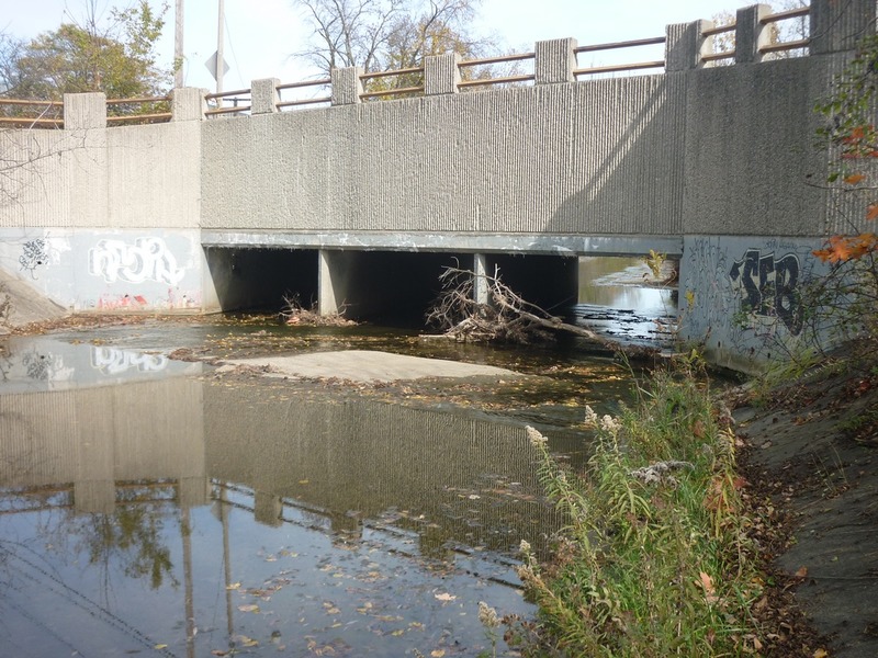
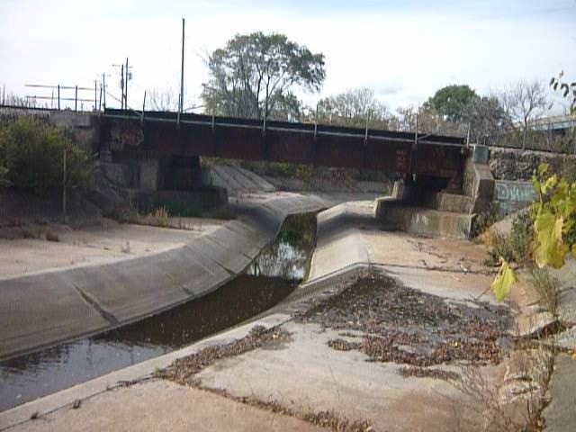
The 115th Street bridge consists of three cement box culverts. Trees often block one or more of these passages. It is highly recommended (while running shuttle) to carefully check for clear passage before putting in anyplace upstream.
As the cement ditch heads into these culverts at 115th Street, the cement bottom has some slope. At some flows, small surfable waves may form in one or more of the openings. If you have the time and presence of mind as you approach, pass, and possibly surf this spot, look up at the 'urban stalactites' forming on the cement underside of the bridge overhead (at the entrance and the exit from the culverts)!
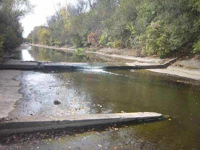
A short hydraulic jump (cement ledge/drop). Measured when dry, this is a 12-inch drop. (All listed heights are measured from the cement lip to the cement base when the river is dry. With flow, some of these will have virtually no drop to them at all, but will vary in amount of backwash/boil.)
This 27-inch cement ledge/drop can be quite sticky at good flows. At 750-850, the center looks unlikely to escape, but running a sneak route tight to either shore, angling toward center on your boof, should put you in the clear.
The cement bottom is uniform here, so if you end up caught in the hydraulic, worst case, you exit your boat, stand up, grab your boat, walk to the semi-steep sloping concrete, empty your boat and relaunch!
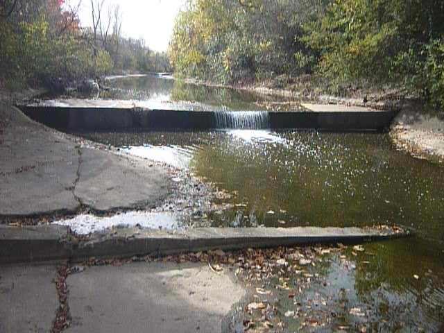
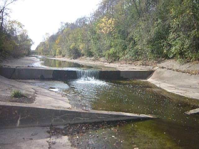
WPR often means 'Wisconsin Public Radio', but in this case it means Watertown Plank Road. This hydraulic jump of about 25-inches tends not to be as sticky as the others at most flows. (At higher flows, water sheets away at the base, and into a bit of a frothy wave/hole that's easy to punch through.)
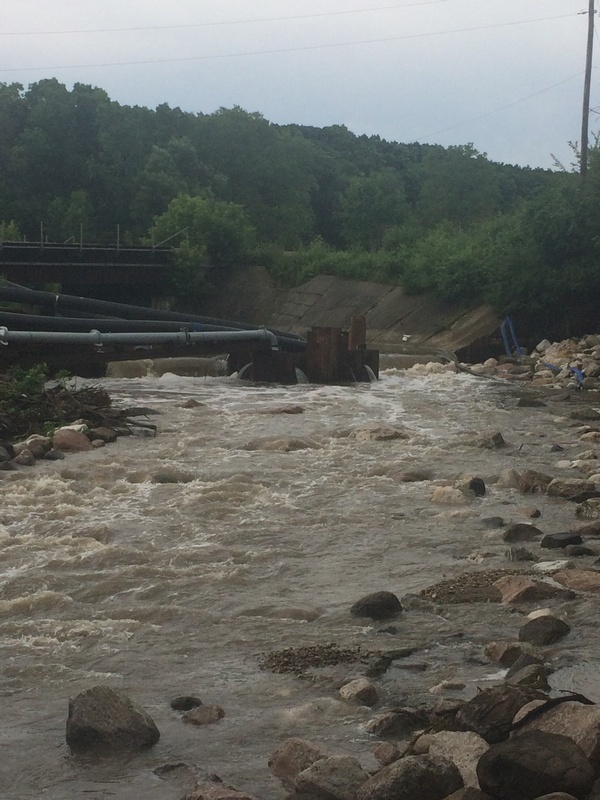
The river heads toward and passes under the railroad tracks just downstream of Watertown Plank Road. (There are actually two levels of tracks, one parallel to the creek, the other on the trestle overhead relatively perpendicular to the creek.) The cement channel slopes a bit and heads toward a vertical corregated steel wall which sends the water careening right before it careens back left in the cement channel below.
At moderate flows, a sweet surfable (catch-on-the-fly) wave forms before you accelerate into the chicane. (Note: at low-to-moderate flows, rather than accelerate, you will grunge and grind through here, as the water sheets so fast and shallow across the wide cement slab.)
Below the chicane, at moderate boatable flows, a sweet rooster-tail wave forms. A strong eddy forms to the inside of the bend, facilitating paddlers who want to eddy-out to try for surfs on the wave.
While there is not a vertical 'jump' here, don't take this area lightly! The jumps may look a bit more intimidating, but they are generally pretty straightforward -- paddle hard, paddle over, and paddle out. However, at moderate-to-high flows, to successfully negotiate this chicane and wave, you will have to be able to pick a path and hit it! (Paddle, maneuver, and be ready to brace!) You could just 'go with the flow', but that strategy is likely to send you careening into the wall midway through the drop, likely missing the rooster-tail wave, and then careening into a very uncomfortable spot against the sloping cement sides downstream. If you flip and end up out of your boat, it will be very awkward to try to recover your gear and remount (floating in the 'inside the bend' eddy) to continue.
Since the remediation projects have so diminished all the action downstream, anyone who opts to do this run has two choices:
-- OR --
I say 'risk' because this is a super-high-visibility location. Unless you are runnig it during cold, miserable weather, there is likely to be walkers, joggers, and bikers on the path, and plenty of traffic around both put-in (115th and the parkway road) and take-out (Hwy.100/Mayfair Road and Watertown Plank Road). This means high potential that someone 'official' might take issue with you paddling this stretch of cement ditch. For that reason, I have never been tempted to try the PnP.
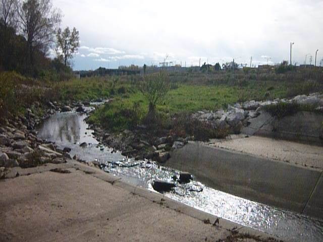
An MMSD project (many years back) removed the cement from the next half-mile of the creek. Flood plains were laid back, and the channel was meandered through broad meadowland. At the 'best' higher flows, water will fill the wider engineered floodplain area here, flowing through (and matting down) the taller grasses and other plants, sometimes allowing one to cut off a few of the meanders. (As this area is being populated with more and larger trees, shrubs, and taller grasses, it has become less simple to cut off the meanders.)
At minimal flows, random rocks litter the channel in a few places (particularly toward the end), but they don't create any interesting features at boatable flows.
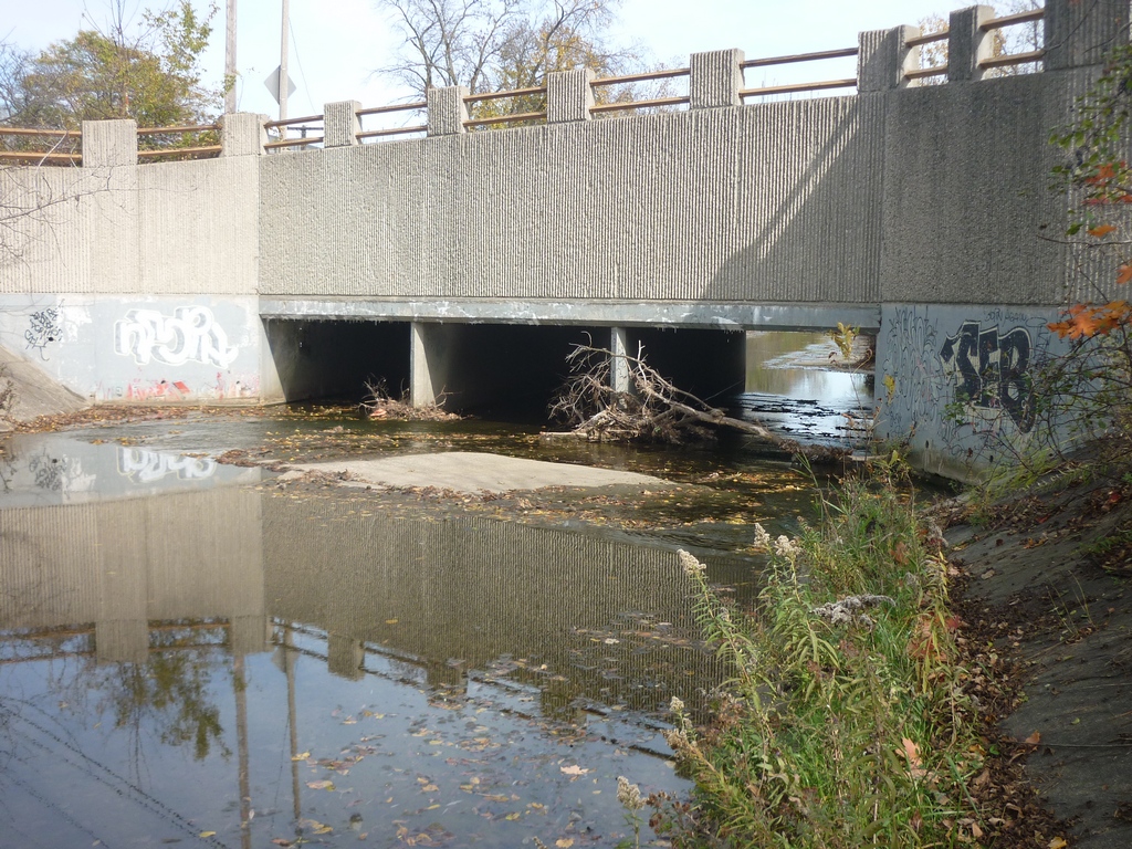
This hydraulic jump (cement ledge/pourover) used to be ~66 inches (at the metal-capped shoulders). Some years back (when they removed cement channelization of the half-mile upstream) they redid the approach and the lip, lowering the center to a 30 inch drop.
Remediation (done during 2017) removed concrete channel from here down to nearly the confluence with the Menomonee River. While a short segment of cement channel remains (to preserve and protect the footing for the railroad trestle), the effective drop is now almost completely gone; Quarried rock fills much of the area downstream of the trestle and backwaters a pool which generally eliminates the hydraulic jump. So, while there may be some wave/hole at some optimal flows, be aware that massive rocks lie just under the surface, limiting advisability of any play here.
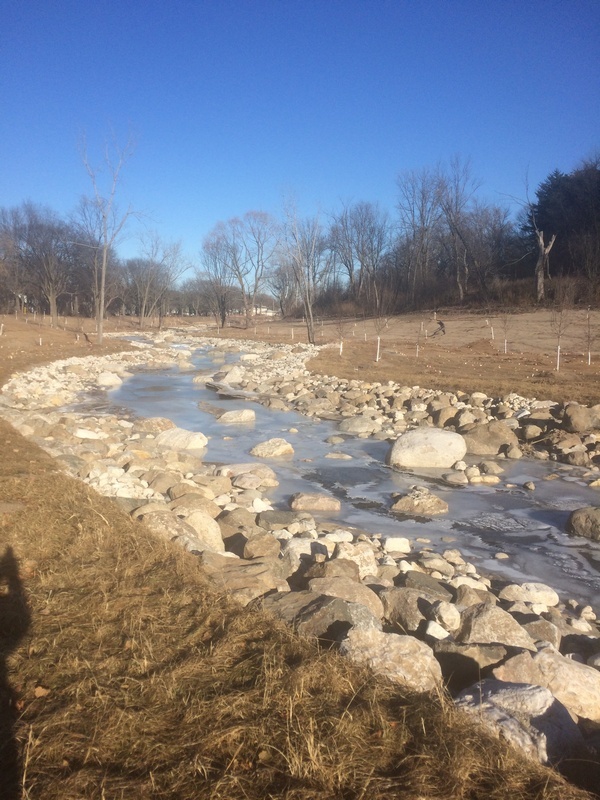
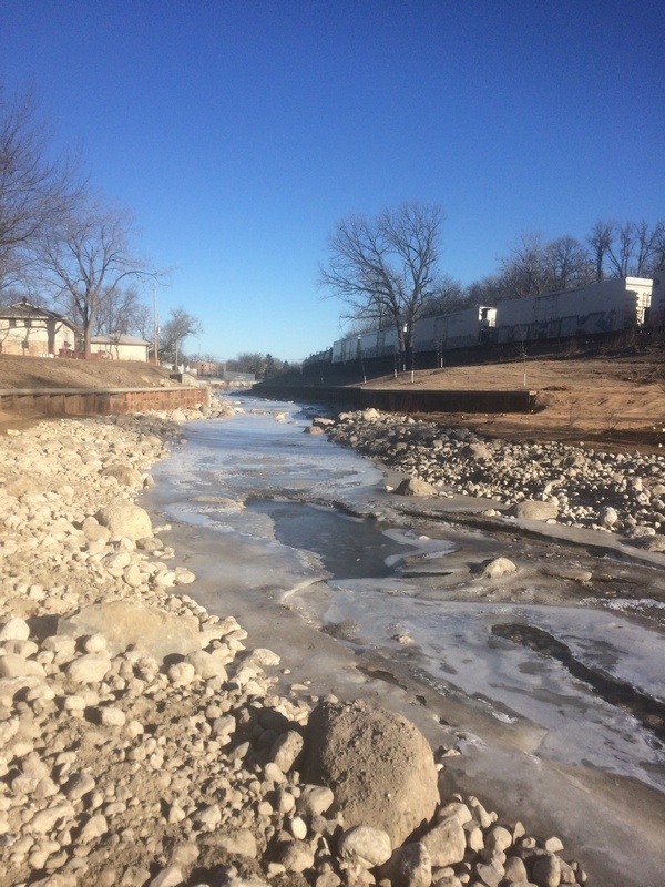
'Remediation' of the next 0.8 mile of Underwood Creek has removed the former cement channel, replacing it with granite boulders of varying sizes (to minimize erosion of this flashy creek).
For boaters, this area will be rock-dodging/rock-bashing at flows of under 250 cfs. At higher flows, anyone unfamiliar with whitewater paddling is likely to think this looks wild and possibly even scary. It is scary (and potentially quite dangerous!) for anyone who may end up capsized or out of their boat! Major rock impacts and possible foot entrapments abound here!
DO NOT TRY TO STAND IN ANY SWIFT MOVING WATER MORE THAN KNEE DEEP!
Competent whitewater paddlers will now find little more than a featureless flush followed by swiftwater (flowing between rocks at low water, or over them at moderate-to-high water).
The first roughly half of this section (from under the freeway to the confluence) had enough room for the creek to be widened to re-create a floodplain and do some meandering of the streambed. Midway down, private properties line river-left, and the railroad flanks the stream to the right, so meandering and floodplain were not an option. As a result, the creek narrows to flow between vertical walls. Flow through here is (at best) swiftwater. At low water, there may be rocks to avoid, but any decent boatable flow everything should be well-covered, making this essentially flatwater.
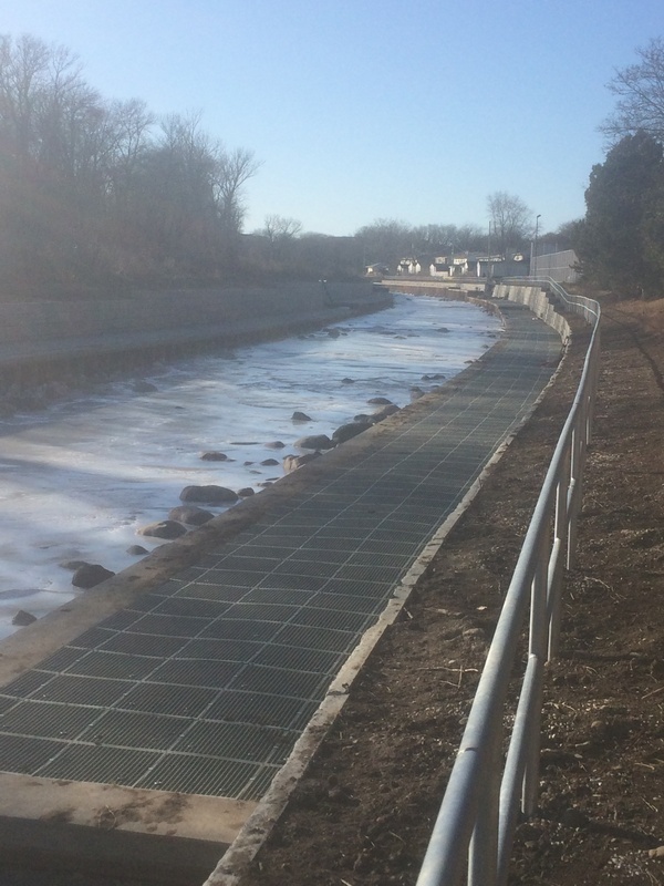
After passing a clearing and a chainlink fence on the left, heading to a low-cut area on the right bank (where golf carts pass under the railroad tracks to access a few holes on the course) a 'two-step' terrace has been created. The lower step appears to have some grates (unknown what purpose they serve).
The bottom and banks become mud and cobble, and shores become tree-lined. (There is no drop nor feature which forms.)
The confluence is generally uneventful. Often the increased flow from the Menomonee actually 'backs up' into the lower part of Underwood Creek, and there is a general lack of any strong merging currents. However, this confluence is your 'notice' of the upcoming concern (see next 'feature').
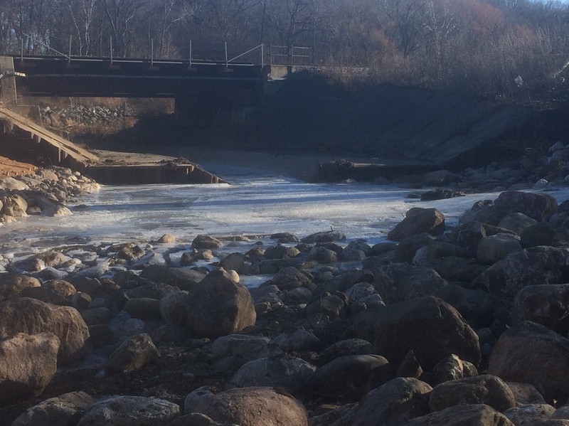
A golf cart bridge (for Hansen Park Golf) crosses the Menomonee River. At flows which are necessary to make Underwood interesting, it is likely to suffer minimal clearance. It is 'duckable' (in a whitewater kayak) up to 1180 cfs but a canoe would be in trouble!
*** As flows reach around 1750 cfs (on the Menomonee gauge) it will be mandatory to catch an eddy (at right is best) to exit for portage.***
(Technically it is illegal to be on the golf course here, but technically their bridge should not obstruct passage on a navigable stream!)
With higher flows yet, (above 2600 cfs) water will flow over the bridge (with only fairly short 'curbs' on the bridge deck, but no rails) and a small wave/hole may form. At super high flows, there likely will be almost no surface disturbance, but at such flows, you are likely to be in serious jeopardy if you continue downstream, as some bridges (at least two pedestrian and one train) will either be low to the water or will have water flowing into their understructure, with very little chance to avoid disaster. In the instance that you are able to pass over this bridge, you are likely to be very sorry if you have not checked bridge clearance at these other bridges on your shuttle upstream. Also be VERY aware whether the river is on the rise or declining flow.
This is the first convenient access point (take-out) after Underwood confluences with the Menomonee, thus is our listed take-out for a run on Underwood Creek.
However, any paddlers who run Underwood Creek may opt to continue down the Menomonee to enjoy two very different experiences: a relatively lower-volume cement ditch run (on Underwood), and a relatively high volume run (with the Menomonee having about 8-times the drainage area thus likely something near 8-times the flow). Please be VERY aware of flows and how they may be changing even while you are paddling, especially if raining while you are on the run.
You may opt to just finish the upper section (MenWesTosa), or continue to the lower section (MenTosa) for the best whitewater on the run. (Refer to each of those descriptions for complete info on what you will encounter, and recommended access points.)
Apr 11, 2025
Jan 14, 2018
Heading past a condo complex (river-left) and toward the Hansen Park Golf Course area (river-right), a 'two-step' terracing has been done. The lower terrace has metal grates (not sure what happens when flow rises to this point), and the upper terrace has a metal railing (to guard against people not realizing there's a sudden dropoff, and provide a 'riverwalk' area, I suppose).
Jan 13, 2018
Partway down this final stretch, where private property prevents meandering the creek and laying back a floodplain area, the creek was widened a bit, and now flanked by vertical walls. Rocks in stream seem (perhaps) a bit less prevalent (not so many huge boulders to encounter at low-to-moderate flows, compared with the earlier stretch from under the freeway).