| Difficulty | I-III |
| Length | 8 mi |
| Avg Gradient | 5 fpm |
| Gauge | Cape Fear River at Lillington, Nc |
| Flow Rate as of 1 hour | 1.01 ftbelow recommended |
| Reach Info Last Updated | December 12, 2025 |
River Description
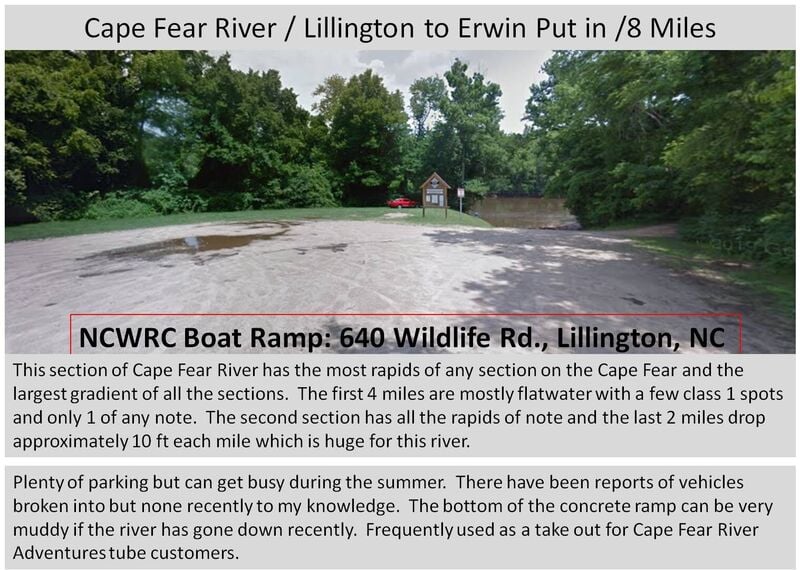
Put-in:
Wildlife Access Road Boat Ramp downstream from NC-210 in Lillington.
Take-out:
NC-217 bridge near Erwin.
1. River Left under bridge (steep)
2. River Left past Campbell Falls Rapid (short portage)
3. River Right under bridge (overgrown/steep)
Description:
This is a popular section of the Cape Fear due to the many paddling opportunities, reliable flows, and proximity to the Triangle Area. This section begins with several miles of flatwater with some Class I-III rapids mixed in. During the summer expect to see numerous recreational kayaks throughout this section as Cape Fear River Adventures rents kayaks for this section and it has become very popular for this region. The parking lot on Wildlife road is also usually packed by mid day due to all the recreational boating and tubers coming from Cape Fear River Adventures
As described in the comments, most whitewater paddlers will not paddle this section due to the 4 miles of flatwater at the beginning however at higher levels (4 ft and above) the 4 miles are not too bad with the flow and the second 4 miles are worth it. This section is perfect for beginners or novice whitewater paddlers to learn on. The flatwater gives them plenty of time to learn to control the boat and then every rapid has flatwater after in the event of a swim in addition to plenty of strong eddy lines to practice on and at most levels there are many places to surf. At levels above 5ft, the waves get bigger and the whirlpool effect and cross eddys become bigger in addition to the water is up into the trees on the banks so recovering a capsized kayak becomes more difficult and a good roll is highly recommended.
Be aware that homeless have taken shelter under the bridge on the river left side of the river in Erwin and most likely due to that the property owner on the river left side has posted no tresspassing signs along the tra
...River Features
Put In /Wildlife Rd
Access PointClass: IDistance: 0 mi
Put in on Wildlife Rd in Lillington. Harnett County sign 'H15' mile marker is directly across from this location
McAlister's Falls /Warm up rapid
RapidClass: IDistance: 1 mi
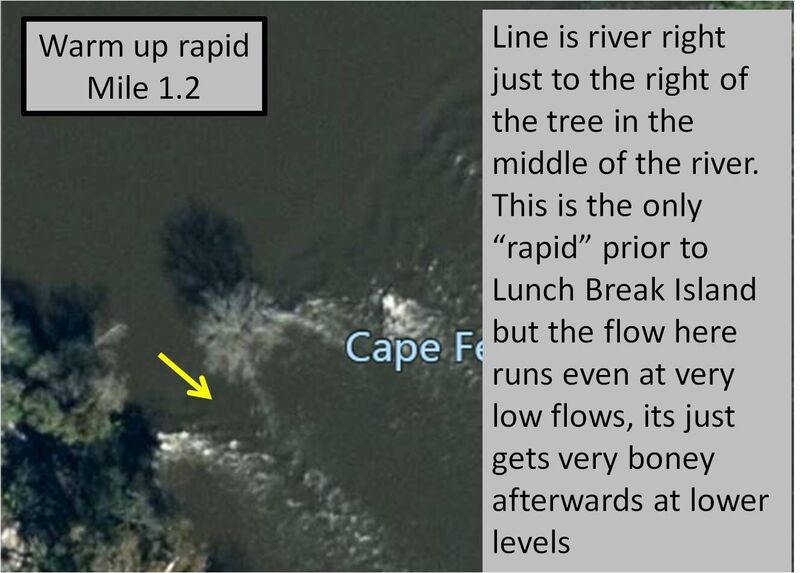
Small class 1 on river right. It is situated between 2 islands with trees that create a nice small green water wave at all levels. This creates a nice defined eddy line to warm up on at the 1 mile mark. At lower levels it can get really boney right after the green wave.(Update:The tree in the middle is no longer standing)
Clark's Fish Trap Remains /Lunch Break Island
RapidClass: IDistance: 4.28 mi
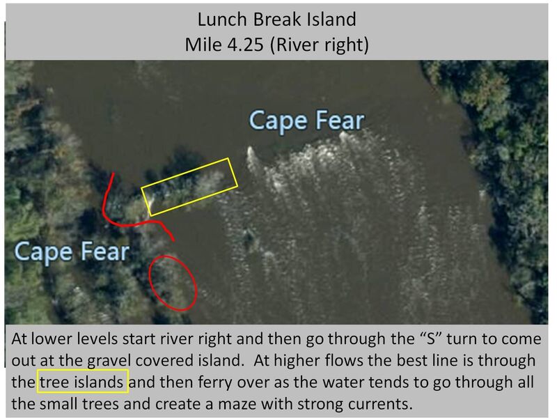
As you pass the H19 sign you will come around a bend in the river and see the power lines. Just upstream from the power lines is an island on river right however you will not be able to see it until you pass the small class 1 ledge from the remains of the old fish traps. This island is a very suitable place to stop and stretch your legs after the 4 mile flatwater paddle to get here. It is gravel covered and usable all the way up to 7'. At 4-5' and below there is a 'S-Turn' rapid on river right that will lead you to the island or you can run down the wide river left ledge class 1 and then ferry over to the island. At higher levels there are many different avenues to the island but be careful if you go too far river right you will end up in the middle of all the small trees that line the creeks that run right around the island.
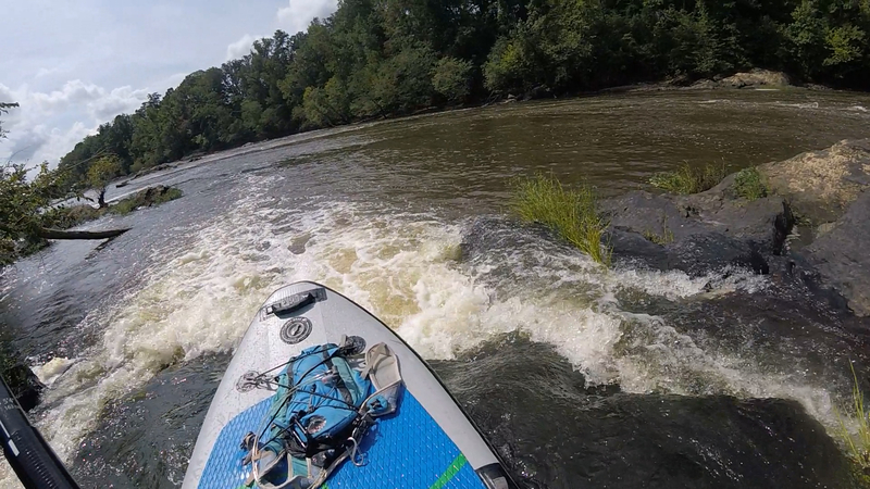
Shaw's Falls (3 Ledge rapids)
RapidClass: IDistance: 4.62 mi
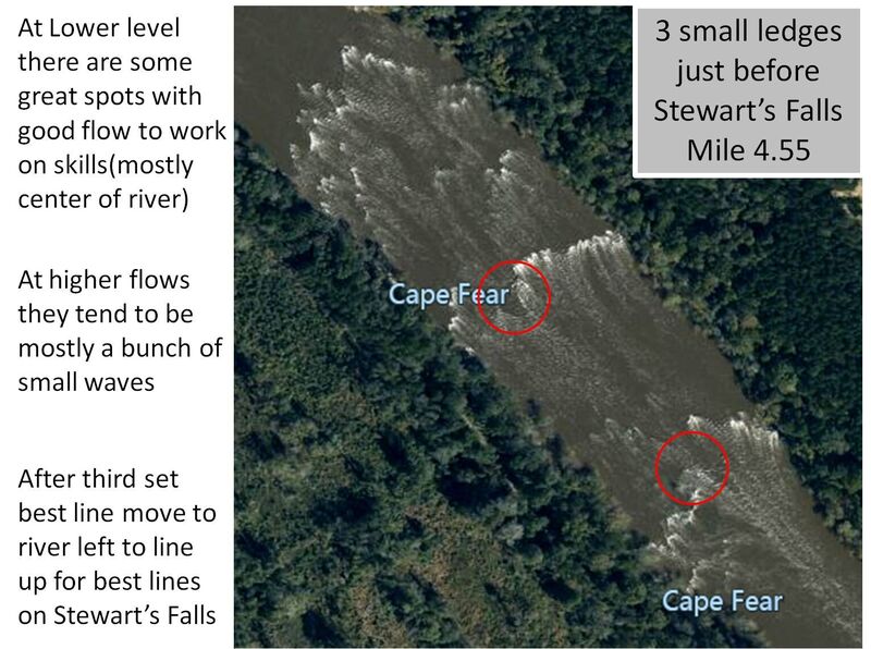
After you leave the lunch break island you will come across 3 small class 1 ledges(Shaw's Falls). At different levels each one provides great surf spots and strong eddy lines. Fun little class 1 spots to play or for newer paddlers to work on skills. At levels above 5ft the waves start to push Class II
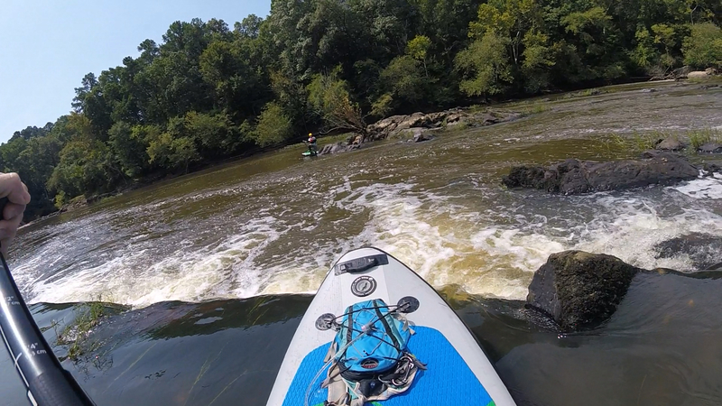
Shaw's Great Falls
RapidClass: IIDistance: 4.99 mi
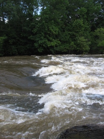
Class II at most levels. At higher levels (4.5' and above) a good wave starts to form off the main little drop just to the right of the river left tree line. This rapid is also known as Stewart's Falls and Wash rack. There is also a few slots that open up at different level across the entire river. At level's above 6 ft a very fun surf wave starts to form in the area of the red circle on the diagram. It is easist to drop in sideways from river left as there are many guardian rocks on the river right side of the wave. 'H20' sign will be after the last portion of Shaw's Falls/Great Falls and before Canadian Fish Trap.
Canada's Fish Trap
RapidClass: IDistance: 5.2 mi

Small chain of islands after Shaw's great falls. At normal flows it produces a small ledge next to it, at higher flows the trees can be a hazard to avoid.
Narrow Gap (Glassy Wave)
PlayspotClass: IDistance: 5.5 mi
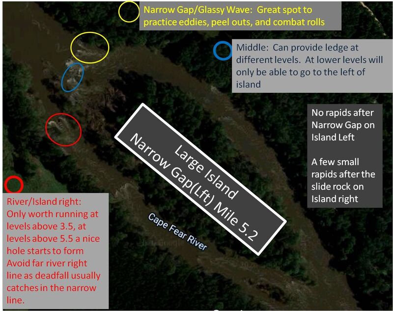
Most of the water is confined to a thirty foot channel through a cleft of bedrock. This is a very popular spot for practicing numerous eddy moves and rolls. Some of us even like to take a swim through this one in the summer (safely). This rapid washes out at high flows, and low flows. 2'-3' seems to be when the Narrow Gap forms a surfable wave. That said, there is something to do at all levels on this rapid. At higher levels (4-6'), if you take the river right channel directly across from this feature, a nice hole forms. The hole is formed from water flowing down a rock slide. At about 4.5-5' the hole is stable enough to practice side surfs and 360 spins. It is sometimes refered to as the 'Honey Hole'. At levels above 8ft the center line produced 2 wave holes that are good for surfing.
Smiley's Falls / "H21"
PlayspotClass: IIDistance: 6 mi
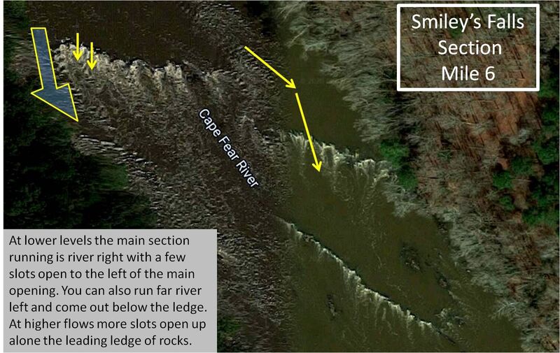
Smiley's Falls is a series of small diagonal ledges moving from river right downstream to river left. They were formed from a dam removal many years ago that begins shortly after the 2 channels merge back from around the island. At any level below 4' the routes through are far river left or river right. River right is the most commonly run with a main wide channel and a couple small slots to the left of it. All of the river right channels provide surf waves at different levels. Both the main channel and the slots tend to have rocks in the drop at different levels and the 2 slots attract logs so ensure you scout if you can before going over. At levels higher than 7ft the right half of the river pushed Class III level. H21 Sign is right at Smiley's Falls.
Little River Confluence
RapidDistance: 6.25 mi
Confluence of the Little River and Cape Fear. The Little River is usually several degrees cooler than the Cape Fear in the summer. Large waves can form after significant rainfall. Great place to practice rolls and cool off!!!
Killing Falls
PlayspotClass: IIIDistance: 6.5 mi
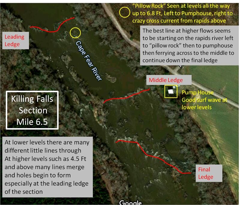
Multiple set of ledges that provide numerous routes down through. At higher levels, 5' and above holes start to form, mostly center to river left on the upper side of the rapid along the first ledge. There is also a large round splat rock river center right after the first ledge that creates a fun cross current. There is a great surf wave next to the pump house at lower flows and another at higher flows that is closer to the island on the pumphouse side. The last ledge can also provide small little surf waves, usually in the middle of the ledge. This rapid is usually a Class II until the levels raise above 6' then they start pushing Class III in certain spots, mostly the play spots listed here.
Final rapid boulders
RapidClass: IDistance: 7.79 mi
Large boulder garden that can create a couple final surf waves at higher flows. At levels above 5 ft there is a glassy wave that opens up just to the left of the river left boulders. At levels above 6ft there is an easy wave that opens up in the middle channel. Be cautious as there are many crazy cross currents in the area around the river left boulders. At lower levels there is nothing here other than a few weak eddy lines but this is the final portion before take out unless you run Campbell's falls and hike back out.
Take Out /Cape Fear River Trail, Erwin NC
Access PointDistance: 7.9 mi
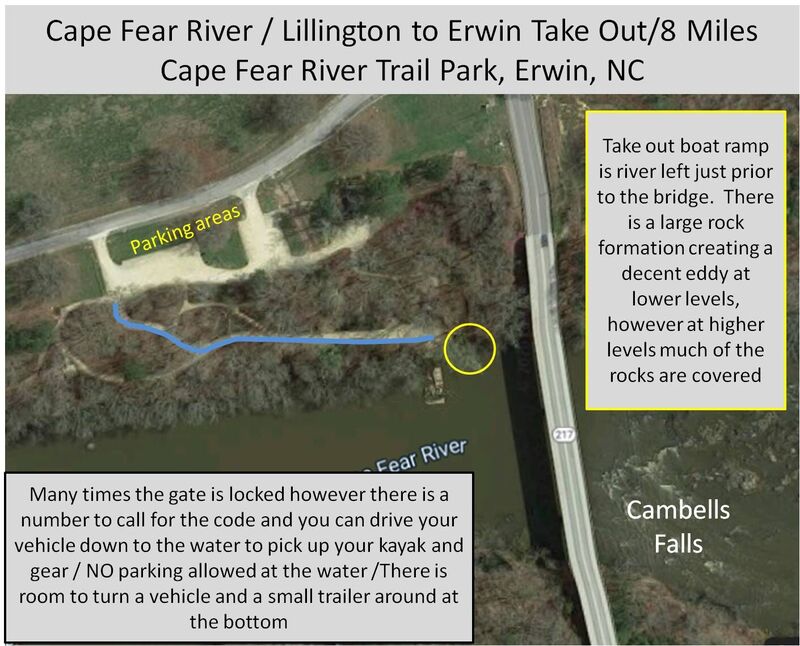
Cape Fear River Trail in Erwin. If the gate is locked, the code is the last 4 digits of the phone number to call. Ensure you do not park your vehicle at the ramp at the bottom.
Campbell's Falls
RapidClass: IIDistance: 8.01 mi
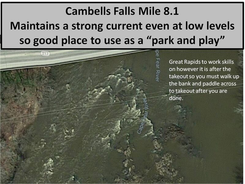
This rapid is river right and can provide lots of play however it is after the take out so you must walk to the top and paddle back across the river. This spot also provides a great park and play option at many levels. At levels below 3.5 ft you can attain back up to the bottom of the little 2' drop which provides a great wave train. At levels over 3' many other routes open up to run and there are some bigger waves to surf that open up starting at levels near 4.5 ft but it becomes harder to attain back up to the top. Only downside to this location for a park and play is you generally have to get out and walk upstream one side or another to get back to the takeout. There is not always a difined surf wave but there is always a strong eddy line and wave train to practice combat rolls, peel outs, eddying, or ferrying. Be aware that the property owner on river left has put up no tresspassing signs so you can no longer paddler over and walk the trail back to the take out. You must either walk up on river right and paddle across or walk up the center rocks and paddle upstream.
Trip Reports
Log in to add a reportWH
William Holman
Sep 29, 2020
I have paddled this section numerous times at numerous levels ranging from 1.5 ft to 7 ft over last 3 years. I tried to update all the information with good diagrams depicting all the information I know. If you are one of the originals who created the profile and rapid descriptions please get with me, I have many questions as to the names of each rapid. If any other paddler has questions feel free to email me. William Holman, Williamjh33@gmail.com
KB
Ken Bowman
Oct 23, 2018
🏄♂️🤙