Trip Reports
Log in to add a reportWH
William Holman
Sep 29, 2020
I have paddled this section numerous times at numerous levels ranging from 1.5 ft to 7 ft over last 3 years. I tried to update all the information with good diagrams depicting all the information I know. If you are one of the originals who created the profile and rapid descriptions please get with me, I have many questions as to the names of each rapid. If any other paddler has questions feel free to email me. William Holman, Williamjh33@gmail.com
KB
Ken Bowman
Oct 23, 2018
🏄♂️🤙
KB
Ken Bowman
Oct 23, 2018
Hala Atcha
CS
Christopher Stevens
May 18, 2017
Paddled this with a friend at 2.2 ft. Do your self a favor and avoid this stretch at that level if you are paddling a whitewater boat. The four mile flat water paddle is not worth the riffles below. In a sit on top though, this would be a nice relaxing paddle.
JM
Jim McNeill
Jan 16, 2017
boated this section yesterday. water level was about 3.25.This is a great section for first time and beginner paddlers. nothing above class II despite what this page says. first 4 miles are flat water and a few class 1s. great to let a new paddler get comfortable before anything happens. many new houses have cropped up in the past few years and Red Neck Campground has more trailers
have paddled it as low as 1.75 and as high as 6.5. between 2 and 4 feet is the best. below 2 and it is very boney. above 5 features start to wash out. above 6 and it is just fast moving water and some waves. the scary part of high water is the number of trees and junk in the water.
?
Untitled
Feb 14, 2012
Alakazaam-information found, porbelm solved, thanks!
?
Untitled
Dec 2, 2011
Three of us made the run from Lillington to Erwin yesterday. The River is remarkably clean compared to previous years. The addition of the park & river access at Erwin is awesome. We used to dread the drag up the bank and through the poison ivy under the bridge. My compliments to the groups that are behind the new access. We need to see more of this down the river. The Cape Fear is a recreational resource that is being overlooked by too many people.
S
Shaun
Feb 3, 2011
Why does the Rapids section of this page read like 'A Guide to the History of Harnett County?' Couldnt we just get some beta?
?
Untitled
Aug 14, 2009
Rapids flood out at 6 feet. Ran it today, 2/21/2010, and it was a lot of paddling.
?
Untitled
Jan 27, 2009
Has any one tried this creek for the putin? Google Map: http://tinyurl.com/d5krmd I paddle Cape Fear this past Sunday (1/25/09) and noticed there was a good flow (both cfs and speed) underneath the Titan Roberts Bridge. The length of this creek to Cape Fear is about 2.5. The confluence of this creek with Cape Fear was wide and poured forth water. Using this as a put-in seems to give only 1.5mi of Cape Fear rapids.
MM
Matt Muir
Nov 19, 2008
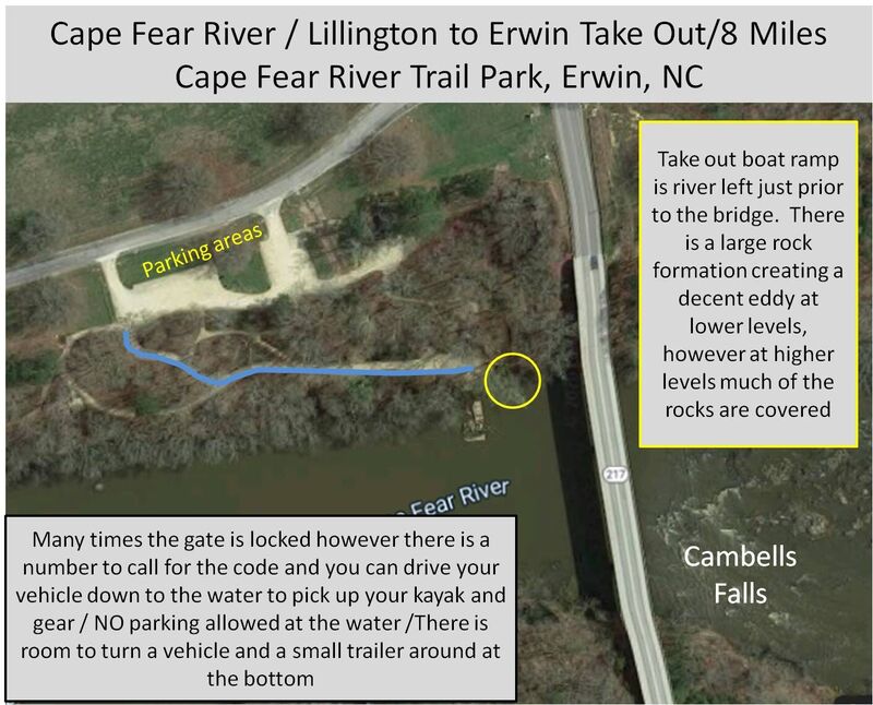
The 'Take-out' info for # 1 'River Left under bridge (steep) is incorrect.
The River Park was opened at this location in April, 2008. It is 16 acres with a take out area for canoes/kayaks. A vehicle (without trailer) can be driven to the waters' edge for easy pick up. The River Park also offers walking trails with overlooks, free parking, restrooms, and picnicking facilities with covered areas.
For further information, please contact Harnett County Parks & Recreation or The Town of Erwin Recreation Department.
Best regards,
Dale Ryals
?
Untitled
May 4, 2008
As of May 2008, there’s a new Riverside Park on this section of the Cape Fear in Erwin (at the Hwy 217 bridge): canoe/kayak access, walking trails, overlooks, restrooms, a shelter and space for outdoor education. Two groups put in almost $1 million to tame the landscape there: non-profit Harnett (Co.) Forward Together and the N.C. Parks and Recreation Trust Fund. It’s managed by the town of Erwin, NC, and Harnett Co. Parks/Rec. Getting up the steep riverbank there is almost heavenly now.
JL
James Lumpkin
May 19, 2007
I went to the Harnett Airport to check on that road which runs close to the river just west of the lower rapid section. The road is blocked with a do not enter sign. I asked the airport personnel and they said it was privately owned, and the owner doesnt want anyone on his property.
JL
James Lumpkin
May 9, 2007
Highlights
BG
Bracken Gentry
Apr 23, 2007
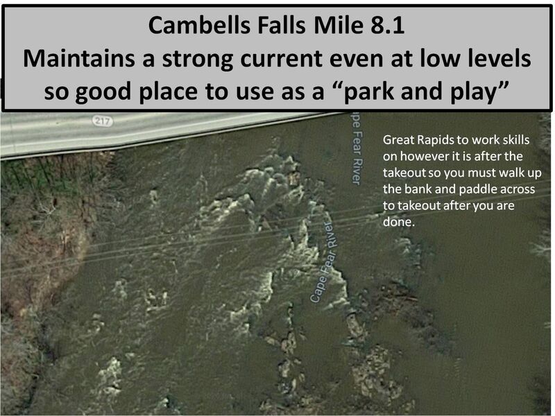
A buddy and i ran it last weekend while it was flooded. the level was around 8.5-9 feet and most of the rapids on the first half of the trip were washed out. its definately more fun at higher levels and new features pop out of no where. the waves that were at smilie's falls where outstanding about 3ft high and glassy. and a 6ft wide hole at Killing Falls made me swim. the last rapid campbells falls could not be run as we would have missed the takeout due to how fast the water was moving and how little the takeout beach becomes during a flood.
JL
James Lumpkin
Oct 8, 2006
Sliding fun.....
JL
James Lumpkin
Aug 13, 2006
You can cutoff about 2 miles of the Lillington-Erwin run by utilizing the Wilderness boat ramp south of lillington. From the river, head toward burgerking, at the third stoplight (Ross Road) take a left and a few miles down you will see the boatramp sign on the left. You will cutout about 2 miles of flatwater making the run about 7miles.
MC
Michael Carter
Jun 24, 2006
Last section of Shaw's Great Falls rapid. Newly refered to as the Washrack. There is an engraving on a nearby rock from 1900. I guess Mr. Stewart found'em first.
Bigger boat in the same hole.
Don Bunch trying out a Diesel on the Cape Fear.
With the sound of banjo's off in the woods, our hero runs the Redneck Campground Falls. Don't run it when the inhabitants are out fishin' for catfish. They dont take kindly to strangers.
CP
Chase Patenaude
Apr 8, 2006
Myself and a group of first time boaters ran the Lillington-Erwin section, approx 8 miles, the other day. At the red neck camp ground/trailer park (mentioned below) there is some kind of rubber coated ramp (river right) we nick named the redneck slip n slide. We found out its really a great ride in your boat! We spent about an hour at this spot pushing each other off and sliding about 40ft into smooth water. Occasional bumps and stalls over rocks did become a little annoying. We all had a great time though and I would recommend this river for anyone's first time paddle or a family outing. If you want to get right into the rapid section I would recommend putting in at the wilderness access area (noted in a below post) outside Lillington. I was in a 6'6' playboat and did A LOT of flatwater paddling before the whitewater stretches picked up.
MC
Michael Carter
Mar 26, 2006
One of the many lines that can be run at this rapid.
View from the rest stop, this place is past the Redneck Campground about a 1/2 mile. We see Bald Eagles here all the time. Great place to rest after a long flat paddle.
JL
James Lumpkin
Nov 3, 2005
You can cutoff about 2 miles of the Lillington-Erwin run by utilizing the Wilderness boat ramp south of lillington. From the river, head toward burgerking, at the last 4-way stoplight (one before the 210-401 split) take a left and a few miles down you will see the boatramp sign on the left. You will cutout about 2 miles of flatwater making the run about 7miles.
JL
James Lumpkin
Jul 2, 2005
I am not sure any rapids from the Lillington-Erwin run have names. We jokingly named this one 'The Washrack'. If you arent river left, you can completely miss this.
Lazy River
For the full-sized version of this photo, click here.
RK
Richard Kofler
Feb 17, 2004
I did the section from the Buckhorn dam to Erwin a number of times, with either my big, old family canoe or my OC-1.
At a good water level, it usually takes 6 to 8 hours, depending on how much playing we do.
The Rock Garden, right after the Buckhorn dam put in, can be a little bit of a challenge at high water levels, especially if a canoe is loaded down with camping gear. At high water levels, it easily can become a class 3+ with large, standing waves.
Richard
DP
Donnie Pardue
Sep 24, 2001
This section is best done in two days, with the respite being a campout at the canoe access only Raven Rock State Park campground. It's marked by a buoy on river right.
Most paddlers seem to bypass the upper section and paddle from the Wildlife Access near Lillington and takeout at the Erwin bridge. This makes for about an 8 mile trip about half of which is white water. An alternate partial trip would be to run the Upper Little River from the second bridge above it's confluence with the Fear, then continue on down to Erwin as a regular Fear trip.
The Fear is good to save for when everything else is bone dry.
CP
Chase Patenaude
Jan 1, 1900
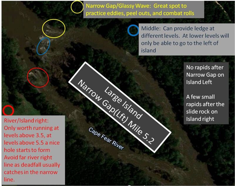
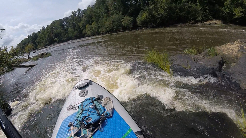
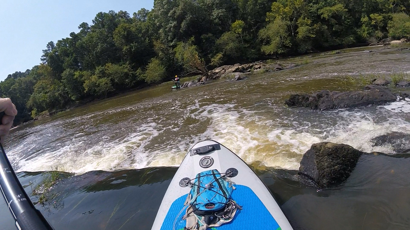
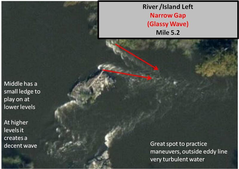
This decent surfing rapid about 5.5 miles from the Lillington put in (river left) forms two distinct glassy waves. We often spend some extra time here because it is the best, and safest, spot on the river to practice ferrying and getting your swiftwater roll on. The rapid dumps out into a nice deep cove where there are some grabby hydraulics along the eddy line on river left. Only danger that we've observed have been copperhead snakes along the bank.
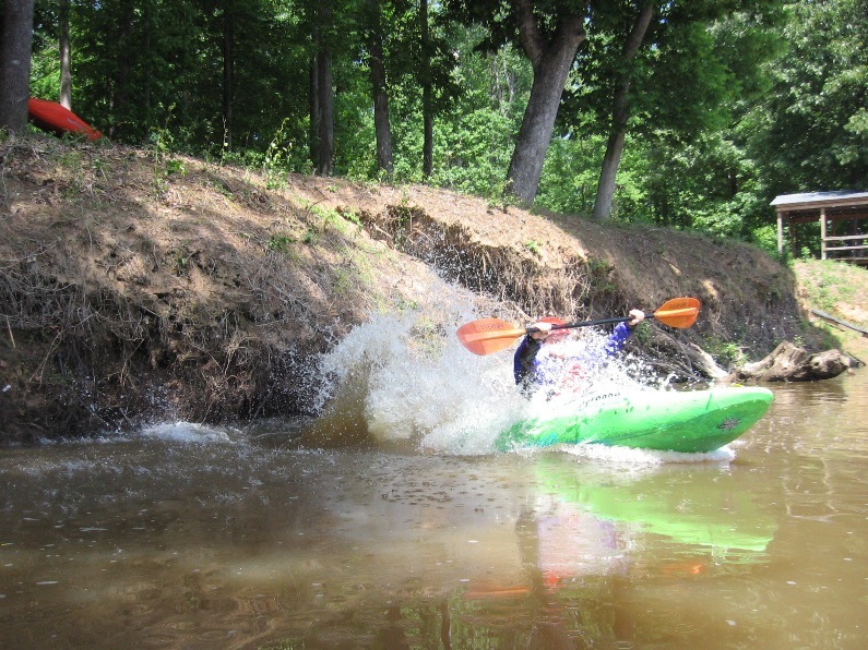
Jake setting up for a successful roll in the narrow gap channel.
WH
William Holman
Jan 1, 1900
One of the many small surf waves that appear at different levels along the 3 ledges
WH
William Holman
Jan 1, 1900
Campbell's Falls Overview
WH
William Holman
Jan 1, 1900
Stewart's Falls 7 Ft, From center looking at main line
WH
William Holman
Jan 1, 1900
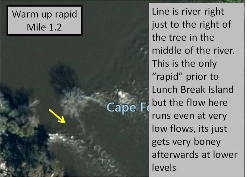
Class 1 Warm up
WH
William Holman
Jan 1, 1900
Overview of Glass Wave
WH
William Holman
Jan 1, 1900
Great rock slide and couple fun rapids but boney below 3'

WH
William Holman
Jan 1, 1900
Take Out Overview
CP
Chase Patenaude
Jan 1, 1900
Great rapid. Fast drop and there's an ez eddy directly after (river right). Take out on in the middle of the rock island (access via the eddy) drop in again or hit any other sections along the rack.
WH
William Holman
Jan 1, 1900
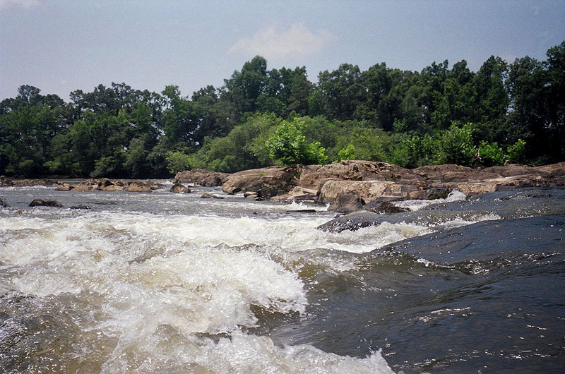
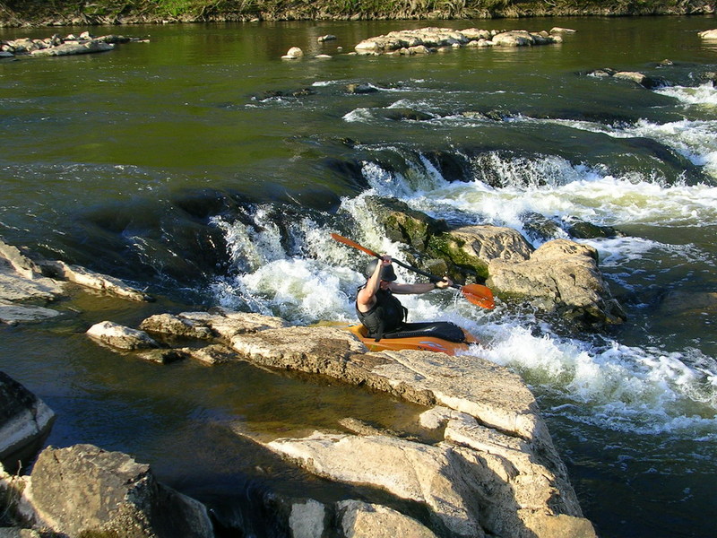
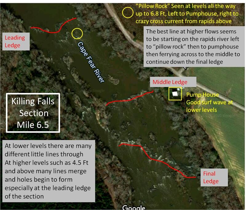
Killing Falls Overview
WH
William Holman
Jan 1, 1900
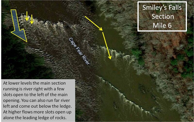
Overview of Smiley's Falls Section
WH
William Holman
Jan 1, 1900
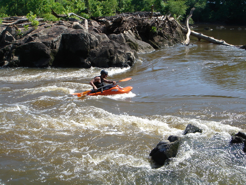
Steve Johnson on slot at Smiley's
WH
William Holman
Jan 1, 1900
Small surf wave
WH
William Holman
Jan 1, 1900
Final ledge, center of river
WH
William Holman
Jan 1, 1900
Approaching Narrow Gap, River left of Island
WH
William Holman
Jan 1, 1900
Steve Johnson going over final ledge
WH
William Holman
Jan 1, 1900
Stewart's Falls main line from center of river looking to river left
WH
William Holman
Jan 1, 1900
Stewart's Falls main line, river left from center
WH
William Holman
Jan 1, 1900
Surf wave in slots to the left of main channel
WH
William Holman
Jan 1, 1900
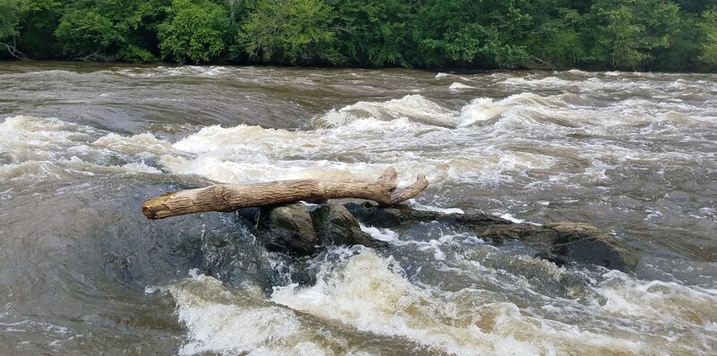
Warm Up rapid river right mile - 1
WH
William Holman
Jan 1, 1900
also referred to as Shaw's falls and Washrack
WH
William Holman
Jan 1, 1900
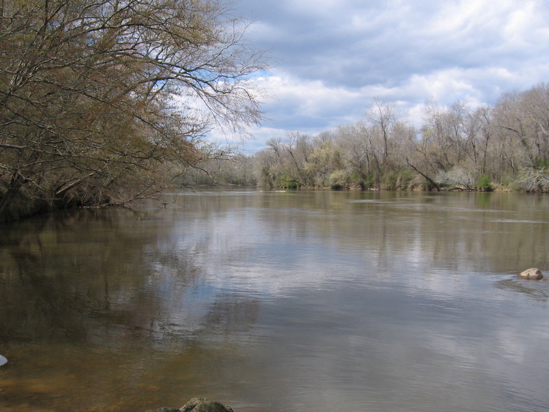
Overview of CFR Lillington to Erwin
WH
William Holman
Jan 1, 1900
David Freeman on small surf wave at 7 Ft, Mile 7.5 center of river between rocks
WH
William Holman
Jan 1, 1900
Overview of Smilie's Falls
WH
William Holman
Jan 1, 1900
The island provides 2 routes. One is Narrow Gap which is great at all levels, at levels above 4' the right channel can provide a fun route as well