Smith
1) Route 104 to Cass Mill Road

| Difficulty | IV |
| Length | 0.8 mi |
| Avg Gradient | 89 fpm |
| Gauge | Smith River Near Bristol, Nh |
| Flow Rate as of 54 minutes | 1.59 ftbelow recommended |
| Reach Info Last Updated | June 27, 2023 |
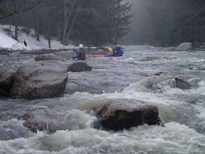
The Smith River in central NH is a steep, spring runoff river. This section parallels the old route 104 (Smith River Road) which has long since been bypassed by the new route 104. In winter/early-spring, it is usually plowed just past a bridge over the river, which is the normal put in. Early in the season you may wish to carry (or drag over the snow) upstream a little to access one of the good drops on the river. Some people prefer a little warm up and will drive the extra half mile upstream on Smith River Road (or, if it is snowed in, the new route 104). Access the river at a left turn on Smith River Road (once again only plowed up to the last residence on the road).
The run is continuous from the put in. The most difficult rapid is located just upstream from the Cass Mill Road bridge. Ray's Rapid can be sneaked on a small channel on river left, but is often choked with logs and ice early in the season. The river slackens a little after the bridge.
While the listing name suggests Cass Mill Road as the take out, more usually boaters continue to a clearing formed by some overhead power lines. (From the road, you will be able to see the river in the valley.) Optionally you can continue two additional miles downstream to the take out at Berry Road bridge. This part of the river is mostly class II with a few strainers to avoid. (See additional listing.)
Put in elevation725'Take out elevation570' (481' at Berry Bridge)Total drop155' (244' to Berry Bridge)Average drop/mile 89'(65' to Berry Bridge)Distance1.75 miles (3.75 to Berry Bridge)River width average 25'River geologySmall to medium granite boulders, some ledgesRiver water qualityGood, clarity averageSceneryNice river valley usually sometimes within view of
old route 104, a few homes/camps on the banks.WildlifeOccasional deer, hawks, otters
Dec 13, 2014
Paddled the Smith today at 5.0ft.
Confirmed the tree that was previously in Rays is gone. No other wood of note as far as the powerlines.
Apr 21, 2013
2013 April: Smith is clear of wood from intersection of old Smith River Rd & Murray Hill Rd (43.54076, -71.82057) to the power line easement after Cass Mill Rd (43.56112, -71.78730), including both routes around the island - Ray's Rapid - approaching Cass Mill Rd and Class II, except for Ray's Rapid (III), @3.82' on the Bristol gauge.
UNNAMED FALLS: We cannot find previous discussions of an unnamed waterfall and rapids farther downstream, 'Pre-file Falls'(?) [IV-V] running from the bridge at the intersection of Smith River Rd and Borough Rd (43.56112, -71.78730), to a take-out on Smith River Rd (43.569134, -71.738051) opposite a wide, distinctively cleared yard on the south (right) bank of the Smith. These drops significantly precede Profile Falls farther downriver. Both Profile and Prefile Falls clear of wood 4/19/2013 and runnable @3.82' on the Bristol gauge.
Sep 11, 2011
The Smith river was paddled (post Irene) on September 10th and found to be clear of debris and without any noticable change in river features with one exeption. There is a river wide strainer on the left channel of the Cass Mill rd to Berry road section. A short portage on the left is necessary or take the narrow bypass channel (also on the left) if it looks clear.