Moodna Creek
Pleasant Hlll Road to 9W(Murderer's Creek)
| Difficulty | II-III+(IV) |
| Length | 5.4 mi |
| Avg Gradient | 50 fpm |
| Gauge | Rondout Creek at Rosendale Ny |
| Flow Rate as of 24 minutes | 8.92 ftbelow recommended |
| Reach Info Last Updated | December 20, 2024 |
A remote camera uploads pictures to show current levels at kccny.org/locations/moodna-creek/ and rivercam.io/
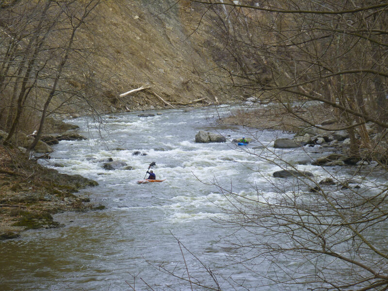
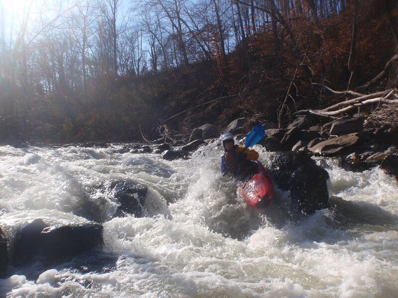
It's generally a Class 2-3 river at normal levels with the Class 2 warmup upstream of the Rt 32 bridge. At higher levels the very portagable and identifable pillars rapid gets into class 4.
The river holds well and isn't miserable at low levels.
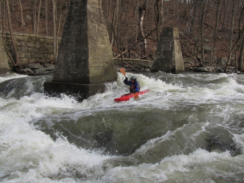
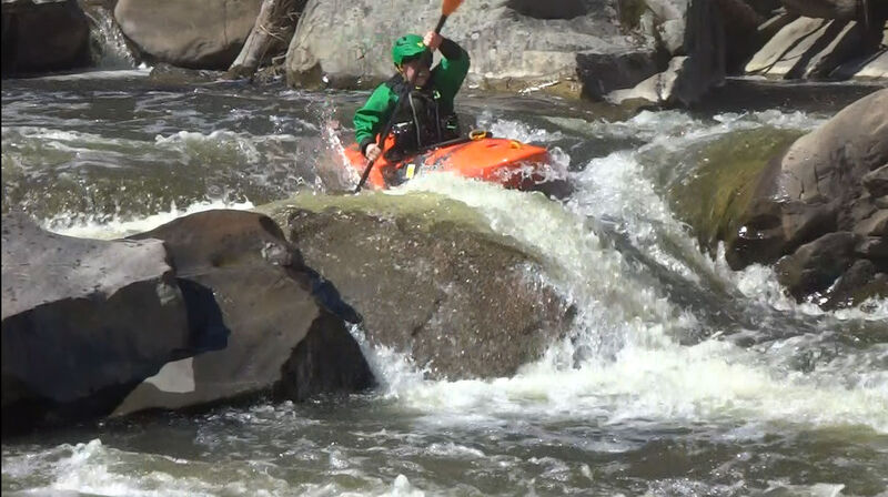
The hardest rapid is Hell's Teeth (aka Pillars). It has a hole that can get pretty nasty at higher flows...nasty as in it flips a lot of people, but it's deep and spits you out once you get upside down. The center pillar catches wood, often near the waterline , which sometimes isn't very visable.
The most dangerous rapid is Factory below the 2nd dam which drops down a chute of large cobbles.
LOW HEAD WARNING. In the fall of 2021, Hurricane Ida undercut the small dam on river right below the 'packman' rapid, the rocky drop below Forge Hill Road. After passing Forge Hill road bridge, the river turns right down the bumpy 'packman' rapid and then left before a building.
For those who've run the river before, this used to be an inconsequential drop of about a foot. Ida probably undermined the dam (and closed off the river's left channel at normal flows). At higher levels this is a significant recirc and though probably not uniform enough to be a true keeper isn't fun to be in...sneak as far left as you can get away with...at higher levels bump down to the left of the island.
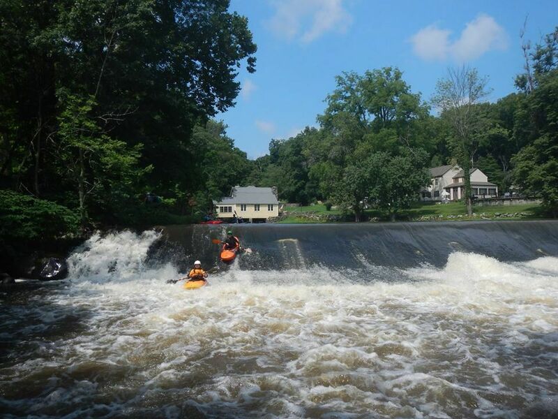
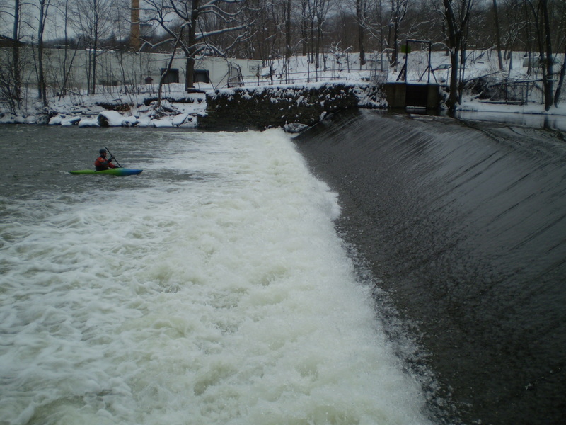
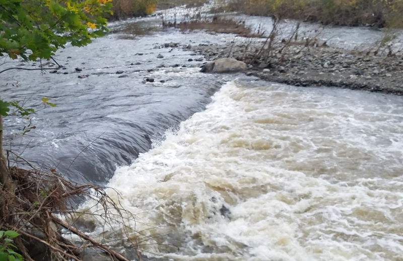
There are two big dams during the run. The first at the Rt 32 bridge you can generally slide over without any problems except for boat abuse.
The second has a kick-up at the bottom that's quite a wall of water at high levels. (2021 update - center dropped so doesn't kick up as much).
The Moodna Gorge cuts thru glacial till and changes after every flood.
...
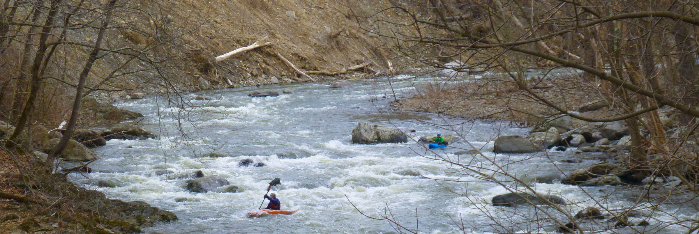
Wonderful quiet section to boat and see wildlife on the banks. At low levels where the gorge is still runnable this section gets too scrapy.
Easily run but a total boat abuser...has a gravelly textured surface and in all but the highest conditions you just sandpaper your way down. Get close to the edge, take a good look and either pick the deepest spot or decide you like your boat and portage right.
Lots of sharp rocks in the run out so not a place to get flipped but if you're in danger of getting flipped here this is good place to call it a day. Note that in the distant past like the early 2000's the rocks were blown out and there were nasty holes at the bottom...and we're probably 1 big storm from this happening again, so like any dam, use your discretion.
Since the dam is hell on boats if you're just running the gorge, parking on the southeast side of the bridge and access either right by the bridge on the west (dam) side or thru woods on east side.
Ist half of this rapid is viewable from the bridge. It's a good gauge. If you're comfortable running/scraping thru this you'll probably enjoy/tolerate the rest of the river.
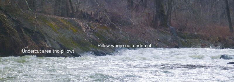
Even more then then the rest of the river Lumber Yard changes with every flood as it's undercutting the right bank. In general is easier and has better eddies on the left/inside and more wood on the outside as you'd expect. The last drop into the pool above the pillars has occasionally been challenging with some moves that can't be boat scouted....but at the end above Hell's Teeth is a good size pool and there's plenty of time to get boats out.
Called lumber Yard as that's what you looking at up on the right bank + the undercut right bank drops a few trees into the rapid.
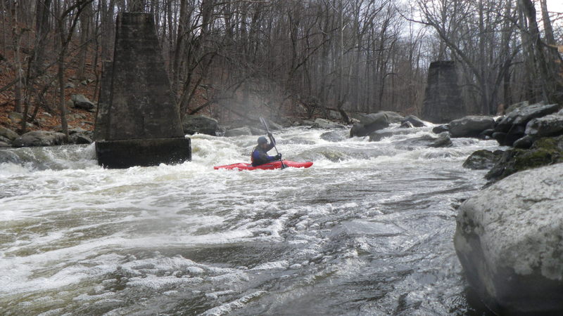
As you come up to Hell's Teeth (aka the Pillars) you will see these 10-15 foot tall piers on River Left. Scout on either side though i prefer right.
Main line is river right moving hard left to drop to the left of the 'tooth' in the center of the flow. Large eddy on far right just above uppermost right pillar easy to hit at lower levels. Recently (summer 2019) something moved offering a tongue in at least low to medium flows as opposed to the previous drop into a diagonal wave coming off the tooth. Sneak route to left of right pillar runnable at all but low levels. From above this sneak looks like a 4' drop into a bad hole, but it's really a sloping drop into a small hole. Head straight over the furthest spot. There's also slightly straighter lines left but they've held wood in recent years. Portage on right.
Obviously any of these pillars could and have caught wood which can be below waterline. Without wood this is a pretty low consequence hard class 3 at lower levels to class 4 at higher levels with a nice pool below.
Left of the island is the prefered route as it has more water. When the ledge in the center tooth is getting hit but not covered with water there's a attainment service to a fun surfing hole/wave just above the huge rock on river left at the bottom.
Right of the island is undercutting and often has awkward wood.
This distinct horizon line is easy to see. Portage on river left which requires a seal launch into a swirl that occasionally catches wood. Take care.
The character of this dam is strange. This dam has a downstream sliding board with a kick up lip at the very bottom. Kick up is less pronounced near center.
It has been run at most flows. At all but the highest flow there's a pool below but at high flows you can't stay in the pool and you drop right into Irene/ factory rapid...so at high levels drop over the dam pretty close together (or portage) so you're able to help each other if help is needed below.
At high flows wood in left putin can make the seal launch a really bad idea. You can also portage right, up a steep slope, thru an old factory floor and put in near the bottom of Irene.
Starting immediately below the 2nd dam. At low to medium levels there's a nice pool below the dam. At high levels get ready as water can flow too fast to stay below the dam.
Generally run to the right of the island down the main shoot with some significant holes. You can see the whole of this rapid from the top of the dam.
Formed by Hurricane Irene in 2011,
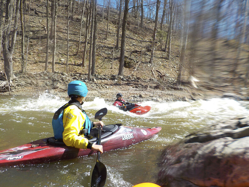
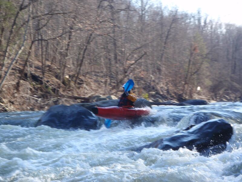
Warning...there's been 2 concussions - none severe - where folks flipped higher up and were rolling up in the meat of the drop. Good place to pull or stay tucked, though rocks moved in 2022 making this a bit less dangerous.
Photo is of boof rock that moved in 2022.
After Irene there's another short rapid and then a 3rd drop. The retaining wall is getting undercut below the factory on river right. At higher levels if you go with the flow you get pushed against some abrasive concrete (not great) but at lower levels a low boat could slide under the edge and mess up your side if not an outright pinning hazard...It's sort of a sloping concrete wall. 2021 update - it's shifted further so still undercut but below waterline at all levels.
This is the 3rd distinct short rapid after the dam and starts after a huge rock on left forms a huge eddy. Staying left away from the wall isn't hard.
At higher waters nice surfing with eddy service at the bottom of the first 2 drops.
Another island. Right is a drop and left turn into a rocky, forested near cliff of 20' or so. More water goes right which turns right and water pushes up against a big rock that tends to collect wood. Shouldn't have to say that if it doesn't look good get out. At high water the island will be inundated and you'll want to scout /portage on right. Several Mike's have had trouble here. 1 liked to swim it. Another got stuck against wood. Do we need to remind you that wood is the biggest hazard on a river like this and if you aren't feeling good about the wood you should get out and scout or walk? Left is narrower and more likely to be completely blocked. 2021 update. Lots of water going thru strainers between big rock and left bank. Anyone getting this far should have the skills to avoid but...

Named for a hemlock grove that used to be on the right side of the island. Now it's mostly run river left. Large rock on left has narrow passage that can get a little choked with wood. After that a wave train followed by a nice reactionary type hole where the right side river joins back with the left.
Flow splits around a small island which gets inundated at high water as river turns right. As of spring 2022, the left side is now (once again) a woody mess. Last significant rapid, recognizable as it starts with low island. Stay right of the island and you're fine. Flow isn't strong enough to be dangerous to anyone who's made it this far, but you're too far into the mess to paddle out. (This left line used to put you over a drop).
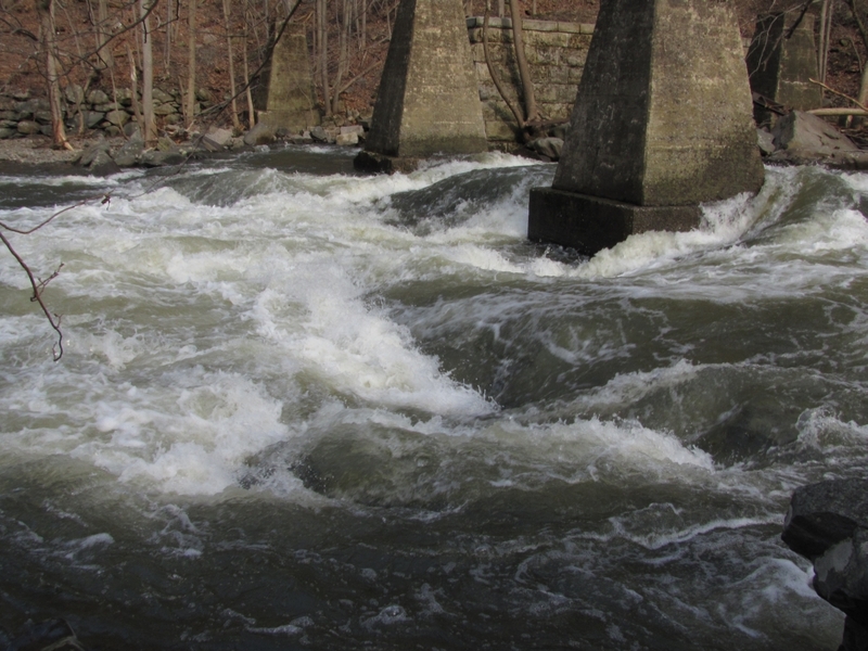
Wide shot under the old forge bridge clearly showing the placement of the I-beams. Hurricane Irene moved the river a hundred feet or so to the right, destroying the bridge and burying this former hazard.
Nice squirt line on river left.
This is the end of the class 3 section.
Pull out on river right just below the bridge or go down to 9w or the Hudson.
Ida undercut the small dam on river right below the rapid below forge hill road. After passing Forge Hill road, the river turns right down the bumpy packman rapid (more water right) and then left around a building. For those who run the river, this has been an inconsequential drop of about a foot. Ida probably undermined the dam - or the factory undermined it to shore up the wall afterwards. At higher levels this is a significant recirc...sneak as far left as you can get away with, but no further as speed is the key and there's fu rocks. Winter 2023 someone got caught in a high run (barely touching the rt. 32 dam) and it was waist deep.
At higher water a sneak route has opened up at left.
Alternate pull out at 9w that gives you a pretty stretch of easier river. Gravel drive just after crossing river (northbound) and below/south of Storm King Marine. Adds a mile + with several nice class 2 rapids including one that has a lot of jagged rocks and no clean line - but with the full upper section makes the whole run decently long and paddlers challenged by the gorge won't be bored by this section. This section caught a massive amount of wood after Irene and had a few perilous routes thru the strainers for awhile. Until 2019 had a porta potty at the pullout but now there's not much privacy to relieve yourself. Building has an overhang that gives you a dry place to change in the rain.
Pullout is an boat launch ramp that ends at normal water level. Usually somewhat awkward for the first person out but if they are nice they can pull the rest onto the ramp.
This was an official kayak launch but it's just above tidewater so in most conditions you can't paddle back up from the Hudson to here. Plum Point Park has much better launch for rec paddlers.
Flatwater marsh leads to the Hudson. Pretty but pretty boring in a whitewater boat.
Dec 20, 2024
Apr 12, 2021
Dec 27, 2019
Clean of wood by Moodna /seldom run river standards. No wood in the way from Pleasant Hill Road to Forge Hill Road on Dec. 22nd (after December's ice storm). Of course there's always some wood on the outside of bends and things could move...