Moodna Creek
Pleasant Hlll Road to 9W(Murderer's Creek)
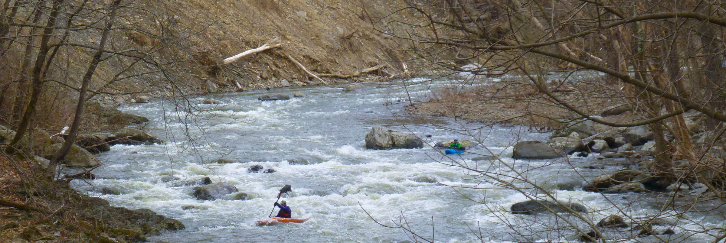
River wide angled log at the bottom of the factory rapid below the 2nd dam not visible from above or below dam. Class 3ish rapid has settled down into very fast water at this point but not much chance to eddy out before you have to maneuver. At higher levels you can go over it river right. At lower levels under it at river left. Hard enough rapid that folks pushing their skills might want to portage or sneak river right (eddying out after running dam).
Honestly, the center pillar catches so much wood you should always scout if you don't have beta since the last high water. Usually you can eddy river right above the pillars.
This log was hard to see and made both the main line (left of the pillar) and the cheat (right of the center pillar) dicey.
Enterprising beavers moved this log but more will surely come.
Further down in rootball, right after a hard right turn with multiple islands....there's a log stuck across the flow center right. Far-right is the safest line, with the center left passable.
A ~ 20-foot log with a rootball is stuck on the center pillar as of July 2023
The log at the level of the ledge on the edge of the main line to the left of the center pillar and blocking the sneak line to the right and below the water line at higher levels. The safest line is probably dropping straight down the left side about 10′ to the left of the center pillar, but the rootball looks like it could snag you if you get close and the drop to the right of the center pillar that a number of folks have fallen into in poorly run sneak routes.
If in doubt of your abilities scout and consider walking.
We doubt this will move on it’s own unless the river really gets up and it’s not visible at higher levels.
We’ll post here when we know its moved or we get it cut out.
In the ever changing Moodna, the left side of rootball is now (once again) a woody mess. Last significant rapid, recognizable as it starts with low island. Stay right of the island and you're fine. Flow isn't strong enough to be dangerous to anyone who's made it this far, but you're too far into the mess to paddle out. (Left line used to put you over a drop).
Lowhead dam below forge hill road and pacman is getting a little less retentive, but still should be approached with speed and taken as far left as you can get a clean line.
Ida undercut the small dam on river right below the rapid below forge hill road. Though AW won't let us edit the run, many folks take out at 9w. After passing Forge Hill road, the river turns right down the bumpy packman rapid and then left around a building.
For those who run the river, this has been an inconsequential drop of about a foot. Ida probably undermined the dam. At higher levels this is a significant recirc and though probably not uniform enough to be a true keeper wouldn't be any fun to be in...sneak as far left as you can get away with. I'll try to post pics on the actual rapid.
Water quality issues are generally bad due to septic overflow immediately after heavy rain, but generally clear quickly.
The river had severe water quality issues today with poor visibility and sewage stench throughout. I would avoid boating here until this clears.
.
A riverwide strainer follows the Irene rapid below the second dam that can be portaged river left.
A previous ledge or former dam feature has may have shifted since Ida and increased the retention of the hole there. Its' possibly the hole referred to in the root ball rapid below, although Ida and other summer storms have somewhat changed the description of these rapids. It resembles a low head with a long boil line.
DANGEROUS CONDITION AT Rt.32 BRIDGE Just underneath and below the Rt.32 bridge are two yellow cables from the nearby construction job. They are low-voltage communication wires, apparently, and are just above water level at a medium/low flow. They span the entire creek. At higher levels, they may pose a very serious risk. Eddy out on river right underneath the bridge to size up the situation and/or walk around the right bank where the wires converge.
Anyone who runs this river still should hit me up need people to run this with
New fallen tree all the way across the left channel/main line of Irene below the second dam.
I'll try to get my chainsaw out there when the water level drops again.
Ran the Moodna at a high level sometime in March, 2010. It appears most or all the wood is gone or at least under water. There was a fair sized wave in front of the pylon on the right (the one that that you pass on the right, to run the right slot without the hole). I'm not sure if this wave is created by wood or the pylon but unless you intend to hit the pylon, it's not really in play. There was a lot of wood, more than usual, in general though. Also, for those that usually portage the second dam on the left, due to new wood and high water, it would have been difficult to portage on the left, so I portaged on the right. There is a hole in the fence to get off the river and a few feet past the dam, another to get back on. Although I run this dam, it didn't look safe at higher water levels.
Ran the Moodna at a 'medium' flow earlier this week. Their are many new strainers crossing different sections. All are avoidable, but many span at least 2/3rds of the river. All the new stuff definitely kept it interesting.
Under Old Forge Road (rte 74), the bridge near the historical marker located at the dirt pull-over, there are metal I-beams under the bridge center-right. There are three rows of 9(?) metal beams equalling 27(?) beams. It creates a serious pinning hazard. They are located directly under the bridge, right of center, and exent several feet past the bridge. I didn't see them until last minute since they were slightly under water but high enough to catch my boat. It was very difficult to push off. Avoid them by getting river left (best) or way river right. If are not able to get left or way right, keep your boat straight and you should be fine, but better to stay clear of them all together. Definetly do not be sideways. The gage was between 5.67 around 1pm and 5.33 at 9pm but keep in mind, I ran this river another day when the gage said less but the river had more water. The gage is a indicator of level, it's not exact. At higher water these beams may be well under water, at lower more visable and at worst, when I was there you will not see them until your stuck on them. Also, take note, recently (Nov 2007), while taking out at said bridge the Police stopped us and told us that we were on posted property and can not park at said historical marker. He was polite about it but firm. Further down the river, on river left just before paddling under the 9W bridge, there's a kayak ramp and parking. To drive there, make a left over the 9W bridge crossing the creek, make another left into the driveway for a building near the creek, drive pass the building (there will be a Kia dealership on the same side of 9W) and you will see a sign for kayak ramp along side the river, behind the building next to the car/auto store.
Dan Spencer posted a photo of the metal pinning hazard under the bridge at http://www.americanwhitewater.org/content/Photo\_detail\_photoid\_39884\_ .
No articles