Cedar Creek

3. Middle Rd. (VA Route 628) to US Route 11(Lower Cedar Creek)

Reach banner
DifficultyII
Length11 mi
Avg Gradient11 fpm
GaugeCedar Creek Near Winchester, Va
Flow Rate as of 1 hour
22 cfsbelow recommended
Reach Info Last UpdatedOctober 4, 2024

River Description

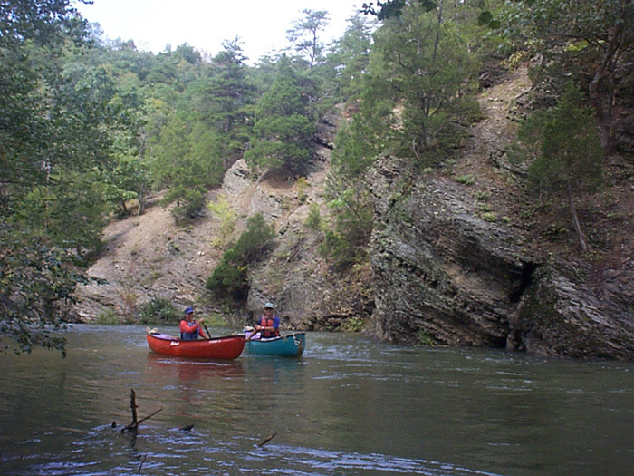
Cedar Creek is a classic VA novice trip with some mild Class II rapids scattered along its length. The Lower Cedar Creek reach is somewhat more interesting than the upper two reaches, as it has slightly bigger rapids and some scenic features such as caves and a waterfall or two.

This is the usual run that includes most of what's interesting on Cedar Creek.  It is a 10.6 mile run from the Middle Rd bridge to US 11.  There are some travertine outcrops just upstream from the Middle Rd. bridge that can be explored by easily paddling a short distance upstream.  Keep in mind that although this is a pretty mellow river, the 10.6 mile run from Middle Rd bridge to US 11 can seem a long way to go, so give yourself plenty of daylight.

The takeout at Rt. 11 provides ample parking (this has changed) and a chance to check some differing RC gauges as described in the flow link.

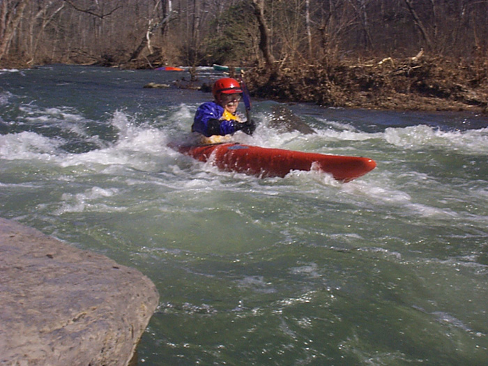
There is a low water bridge about a mile above Rt. 11 that creates a Class II rapid and which can be run right. The best rapids on the river are located here and right below.

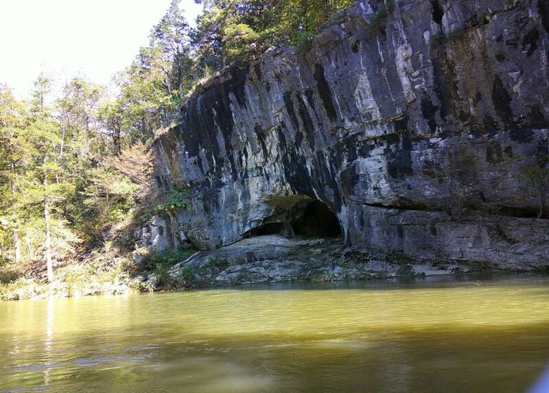
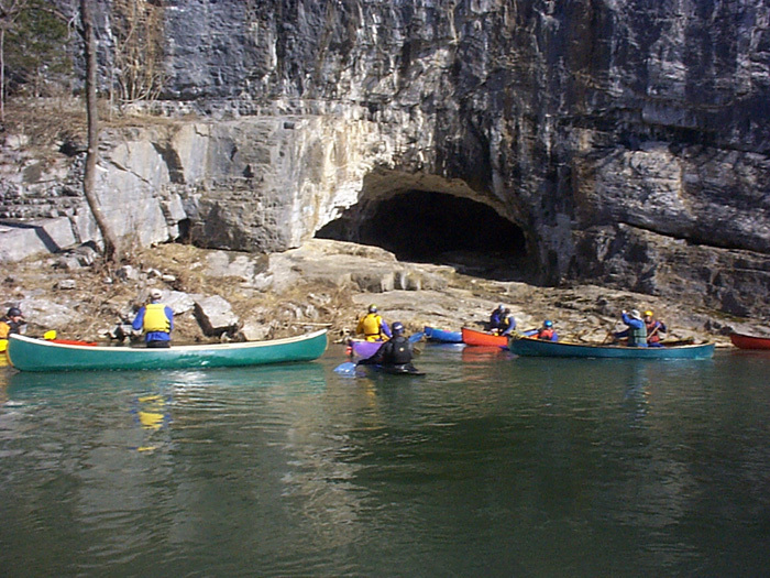
On a recent trip there was an incredible profusion of Virginia Bluebells. There are also a series of scenic cliffs that dominate most of river left and sometimes on the right. These cliffs are full of caves, including short one that you can paddle through.

See Also:

Classic Virginia Rivers, Ed Grove (1992 ed), p. 144.

Virginia Whitewater, Roger Corbett (2000 ed.), p. 79.

Exploring Virginia's Waterways, Ed Gertler (2022 ed.), p. 25.


River Features

Put In - Middle Rd. (VA Route 628 )

Distance: 0 mi

Put In - VA Route 628 -  Middle Rd bridge.  Roadside parking on the downstream side of Middle Rd with private property owner permission.   There are travertine outcrops with associated springs just upstream from Middle Road put-in which can be reached with moderate attainment.

Minebank Rd

Distance: 5.42 mi
Access Point

Minebank Rd. - recent visit revealed that No Parking/No Trespassing signs were now posted at the lower parking lot and at the entrance.  There is still room for no more than three cars at top of hill by the road.

Low water bridge

Distance: 8.74 mi
Hazard

Low water bridge - There is a channel on the far right side where the bridge is broken out.  This far right channel can be safely run.  In the channel, there is a tree over the river that looks river wide, but again there is a channel to the right.  Once safely below the bridge, ferry across the river to the left and run the left side of the following Class II rapid.

Take Out - US Route 11 (Closed)

Distance: 10.62 mi
Take Out
Take Out - US Route 11 (Closed)

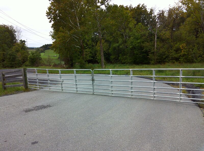
Take Out - US Route 11 - ( The takeout at US Rt. 11 provides ample parking.)  The parking at US 11 has been changed and degraded by the installation of a new fence and gate in 2023 installed by the Commonwealth of Virginia.  This new barrier blocks most of what once was  'ample parking'.  However, one can park on US Rte 11 outside the new barrier and still take out as before.   Space for maybe 3 or 4 cars along road.


Tim Tilson:  The force was in balance today on Cedar Creek.  Many of us had not been on the creek in years, in my case it had been 11.  So it was almost like a new run.  In K1s we had Wayne M, Virginia (aka Ginny) del Rosario and Tony Allred.  It was good to see the last two whom we haven’t see for a while.  In OC1s we had Ginny and Gary Q, and yours truly (Tim Tilson) the trip leader. The water level was around 420 cfs.  We put in at Minebank Rd and took out at Rte. 11 (about 5.2 miles).  There are issues with both these points that I will discuss at length in a post to Paddle Prattle in the next few days.  The trip was uneventful.  We stopped at Panther Cave. No Panthers were seen but Gary reported Brontosaurus tracks. Special thanks to Hendrik Van Oss who warned me about the low water bridge and the correct route. The day started off overcast but ended up with plenty of sunshine, glorious blue skies and a temperature in the mid-70s.

John Duke
John Duke

Nov 21, 2016


The run from the low water bridge to Rt 11 is 12.9 miles.
This may be why it seems a long 10 miles.

BL
Bill Lewis

May 7, 2011


Ran the same section on April 30th 2011as my previous comment. Wood/strainers above Middle Road bridge (1st highway bridge below 623 low water bridge put in) had actually been cleared out more by recent high water. Defunct low water bridge once again has changed due to recent high water. More flow is now being sucked under the old structure and the collection of debris has shifted. This bridge is probably the most dangerous feature on the creek simply because the debris on it changes. No other river wide strainers were on this stretch although a few new ones were laying in the water at an angle. Just be aware of the possibility of wood as you go down.

BL
Bill Lewis

May 1, 2011


Recent trip (April 15th 2011) comments. We put in at the Route 623 low water bridge (10-12 miles above Route 11 wayside in two wavesport diesel kayaks. The level at the Route 11 wayside was a little over ½ ft on the painted gage on the north piling of the southbound lane. You have to walk under the bridge and look at the piling on the upstream side to see the gage. The gage is painted too high as there was plenty of water and even if the level was down another 6 inches there probably would have been enough water. There is also another painted gage on the south piling of the same bridge but one out of wack gage is confusing enough so I ignored the other.
From the low water bridge to the 1st highway bridge is primarily riffles with some swift water in-between. Nothing in this above class 1. This entire section is a good section for novices to get some moving water experience and it is a pretty float. Just before the 1st highway bridge is a logjam (noted in another comment) but I believe it has been substantially reduced from the time of the previous comment. We did not have to portage as we weaved through a narrow gap on the extreme left. The water is deep here and has current so be cautious.
Below the 1st highway bridge there are mild class 2 rapids periodically with a mix of swift and a few sections of flat water thrown in. Some of the rapids are delightful at this level and there are opportunities for practicing eddy turns and ferrying. Nothing struck me as more than mid class 2. Two rapids of note; one where the creek swings mildly R-L-R with a high eroded bank on the left (his is a nice wavetrain that is enjoyable), the second is a right turn with two large boulders on the outside edge but they sit into the center of the flow. Someone with poor boat control could pile into the one farthest out.
Eventually you will pass under a second highway bridge and after the second substantial cleared path powerline (that I remember) you will be getting close a defunct low water bridge. The approach is slow flat water so it should not surprise you. This bridge has so much debris piled on it. It took me a minute to recognize it. 25+ years ago we use to go underneath the bridge. At this level there was one possible run through the middle over a spot where the bridge had collapsed and formed a V trough. Most of the flow piled through a breech on the far right side of the bridge. This is a vigorous drop with a chunk of concrete sitting in the main flow with its downstream edge propped up. I did not run either of these but at this level the far right looked to be a strong class 2. Since I didn’t run it I don’t want to comment too much but its nature is above all of the other rapids to this point in the run. Rebar makes me nervous so we portaged river left. My advice is to always approach this old bridge cautiously as the debris could shift and change the conditions.
After the defunct bridge the nature of the stream changes for a short distance. The rapids are closer and slightly stronger than above but still class 2. A short distance below the defunct bridge is a river wide ledge that had a sticky hydraulic. Again someone with poor boat control or just not paying attention could be surprised and flip. After the ledge, on a fast water left turn are two boulders splitting the stream into small thirds. I’ve seen a canoe wrapped on the first boulder from the left. Again, only class 2 but it comes up quickly after the ledge. Soon you’ll see the railroad trestle and then some caves on river left. From here the rapids drop back to class 1-ish.
All the way down this stream you should be vigilant for trees(strainers) in the water. On this day we did not find any river wide strainers but there were some sticking out a third of the way into the streambed. One old cedar (I believe below the defunct bridge) messes up a fun river right drop. This is at a spot where the river splits through an island.
The trip took us 4.5 hours at this level but we did not stop for rapid play or exploring anything. Much of the land is posted and we really just wanted to check the stream out for bringing some other new boaters along. I highly recommend this run for novices and patient higher skilled boaters. Additionally the Virginia Bluebells and wildlife were plentiful and beautiful.

JS
John Sunda

Apr 27, 2006


My family canoed the lower 12 mile section of Cedar Creek on 4-23-06 starting at the low water bridge. There is a log jam blocking the channels around the large limestone rocks in midriver at the cool rock formations and waterfall/old mill, 2 miles downstream just above the Rt 628 bridge. After scouting it we found that we could land on the left end of the jam in the main channel drag our boats overtop and relaunch from a well placed log in swift current just downstream. We walked our dog around the left side. Alternatively, we could have, with great difficulty, dragged our canoes around the left side of the rocks. There was a sizeable eddy/landing spot on the left above the first rock. In other words you can get over or around it but this is no place for novices. No other obstructions were encounterred. The water level was perfect and the current was swift but the painted guage at the Rt 11 takeout appears to read too low as it read .25 ft when we set shuttle and 0 when we took out but there was plenty of water. The guage at the low water bridge putin was more accurate as it read 0.75 ft. The USGS hydrograph indicated the the guage near the takeout dropped from 3.4 to about 3.2 during our trip. I've done the run at levels as low as 2.8 but it gets a little scrapy with much slower current.

CC
Craig Cook

Mar 20, 2006


One of the coolest things about this trip is the awsome waterfall on the left just a mile or so from the put in...you can actually paddle behing the waterfall. We were accompanied by otters in this stretch who would spook the hell out of you by just poppin up right beside your boat! The easy but fun class II rapids come in sucession....I don't remember any long stretch's of flat water at all. You DO want to start this trip pretty early if you have a long drive home because despite the moving water it's long haul...especially if you make stops for lunch, checking out the caves etc.

John Duke
John Duke

Sep 21, 2003


In the upper 10 miles of this creek there are only 2 rapids that could be considered low class 2
This is one-of-em

John Duke
John Duke

Mar 15, 2003


Dave is runnin a class 2,a couple of miles above rt.11

John Duke
John Duke

Mar 15, 2003


One of the many'COOL' spots on lower Cedar Creek
You can paddle right through this mini cave just below Panther cave