Cedar River
Landsburg bridge to Maplewood Roadside Park

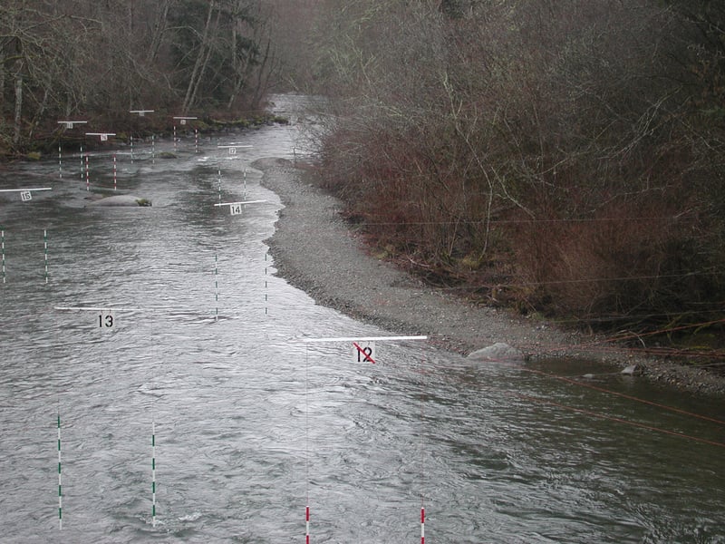
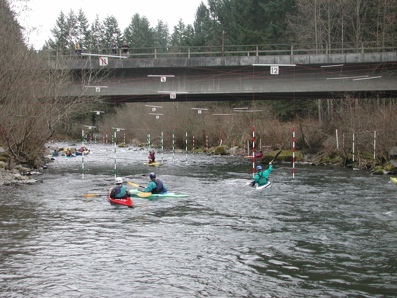
Apr 5, 2026
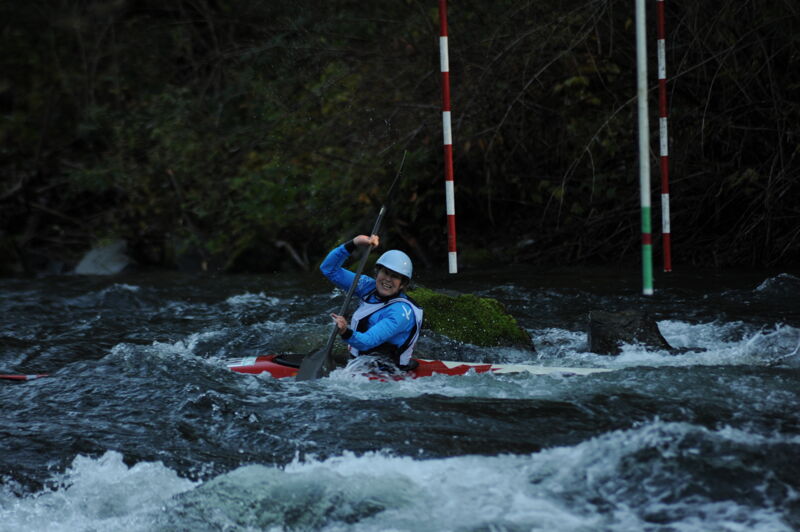
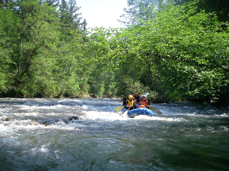
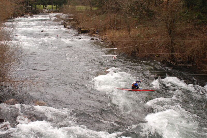
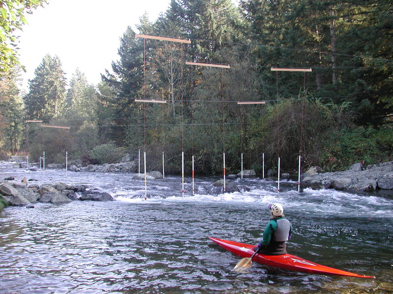
It was a beautiful April day for the Cedar River Slalom race with 40 racers from the United States and Canada with a wide distribution of ages.
Apr 27, 2025
375 cfs- I got stuck on rocks a few times- passible but it would be better with more water. I only had to portage at the Dore-Don log jam. This is well marked with a red sign under the bridge. Portage starts 75 yards down the old right channel and is hard to see from the channel, but is well marked once you get into the trees. There is one river spanning tree that I had to roll on my side to get under. There is a marked log jam “danger stay right” where you can take the right channel and short portage, or you can stay right in the main channel if you are confident in your skills. Numerous other trees and logpiles that were straightforward to navigate without taking out.
Nov 24, 2024
Jun 8, 2024
June 8, 2024 @ 1200 cfs Landsburg to Lake Washington in 4.5 hours. About 1:00 from start, at Dorre Don I took the old (Right) channel which was passible at 1200 CFS, but bony. I did not scout the logjam in the new Left channel at Dorre Don but I expect it is still unsafe. I portaged on right at log jam about 1:10 from start. At 2:20 I floated over a still green spanning tree that may be dangerous at lower flows. I got out to scout two more places, but did not have to portage. At 1200 cfs, many eddies are washed out, there are fewer beaches and bars, some holes where there are usually large rocks. When flow is this high class 3 maneuvering skill may be required to land and portage.
Mar 26, 2023
Between Landsburg and Rotary Park @ Hwy 169 the only notable hazard is the logjam in the new left channel at Dorre Don. We chose to portage on river right of new channel. There is no warning sign on the bridge.
In addition, there is a tree that is spanning the river, which was easy to duck under. There is a sign 'logjam; stay right', where there was ample room on the right side of the left channel to pass- the right channel is shallow and requires walking 20 ft.
Apr 3, 2022
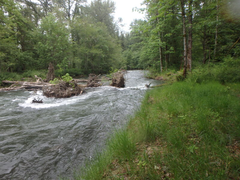
I ran the Cedar river from Landsburg to 15801 SE Jones road on 4/3/22 at 750 CFS (gauge below Landsburg diversion). Except for the stretch from DorreDon to Hwy 18, I found no blocking wood. Many old signs warn of logjams that have moved. All the remaining wood is reasonably scouted from the water at this flow. The new left channel starting at 23109 SE Lower Dorre Don way remains blocked with logs. This is well marked with a sign hanging from the bridge. It is possible to take out on river right, under the bridge, but parking is very limited (two cars?). The top of the new channel looks clear, but there is log jam is around a corner, the water is fast and banks are steep. The new channel has gotten deeper, so the old channel gets inadequate water at 750 CFS. There is a logjam spanning the river between Dorre Don and Hwy 18, which I portaged on river right, but may be passable ducking under on left or right.
May 16, 2021
On 5/16/21, we took 2 canoes from the Hwy 18 bridge to 177th Ave SE. 8.2 miles, 160' vertical, 1.5 hours moving. USGS gage on this site said 950 cfs (there's a NWRFC flood gage, LNDW1, above the Landsburg Headworks which read higher at 1100 cfs, presumably because of the aqueduct to Lake Youngs). We scouted a bend 1 mile in (near Royal Arch Park) where a tree blocks the right 3/4 of the river before a sharp right turn, and ended up portaging over the tree. Scouted another turn 2 miles in but it ran fine. No other scouting the rest of the section. Very few spots with shallow water, easy to avoid. Canoes weren't quite nimble enough (with a 3rd person in the middle) to handle this much flow around the sharpest bends, so we took out after swamping both and losing 2 paddles at the left turn after 177th Ave SE. This was just before some rapids we would have had to scout and the 3 portages, so this was a fine spot to take out anyway. See a map I made (Google 'CalTopo AVGH'). Saw 2 bald eagles, 2 golden eagles, and several mergansers.
May 8, 2021
May 8, 2021 Landsburg to below the golf course, about 18 mi. This is a lovely stretch of river so close to Seattle. At 600 CFS we portaged 4 times. First wood is easy to pass on river left under a cliff. First portage log is after red truss bridge, and can be portaged from gravel bar on river left. The old channel at Dore Don had just enough water that we did not have to portage, but there was much knuckle dragging. We checked out the Dore Don portage, which is about 100 ft downstream from the log jam, on left of old channel, marked with red survey tape. Portage is 800 feet long, no climbing over logs, nice put in. Midway between Dore Don and hwy 18 bridge, there is another spanning tree that we could duck under at 600 CFS. 3 portages in the last three miles, which you can skip if you take out at 47.46614862594574, -122.10495620160793. Some warning signs need to be taken down as the wood is gone or moved. We could see all the wood from what we thought was a reasonable distance, except the well marked logs-exit right after a sharp left at Cavanaugh pond.
Nov 8, 2020
May 16, 2020
Paddle Report: We paddled from the Landsburg Bridge to Belmondo Reach yesterday. The total time was 3 hours and 40 minutes; probably 20 to 30 minutes of that were spent on the shore. The level was about 950, and decreasing during the afternoon. We were in two Aire Tributary Tomcats and one Sevylor sk100ds (this turned out to be a viable little IK for that kind of paddle). The Cedar is beautiful and feels pretty wild for the first stretch. There are no difficult rapids, just a few unexpected boulders beneath the surface that we grazed. All in all, we encountered three places that we took out and scouted; two of them had signs and didn't pose any problems if you stay right, as the signs instruct. The third, right after one of the rusty railway/Cedar River Trail bridges had a bunch of trees blocking the main course of the river, but we could walk and float around to the other side on a side-channel which was shallow and leads past a few houses. Other kayakers walk through the trees and put back in right after the obstacle. There were trees here and there in the water, but nothing that couldn't be scouted and dealt with. At one point, we got out to find a route around a tree that crosses 3/4ths of the river, which can be passed by staying right, but within 100 ft after that, you have to get all the way over to the left and paddle under a log which bridges the river or you will be caught up in a big tangle of roots. We got out, chose a course, and paddled under the log. I talked to people at the take-out who know the Cedar as a tubing river. It might be when the flow is 350 or less; but not at 950. Easy enough as a class II paddle, but you have to keep an eye out for strainers and root-balls.
May 11, 2020
In answer to Kevin Harrang's question: I only know the Cedar River from Belmondo Reach to Cedar River Park, where it passes under the 405 freeway. It is not the sort of river you will want to take a sea kayak on. At least on that stretch, you will need to maneuver quicker and in tighter turns than a sea kayak will allow. At lower flow rates (around 300 cfs), I've done that stretch in inner-tubes, but it was important to be able to get out of the water quickly or to walk when bottoming out. In particular, there is one area with dangerous log-jams which is well marked with a 'Get Out Now!' sign which would be impossible in a sea kayak; even being able to get out in time would be difficult. After that, the river is fairly complacent, but there are still strainers, sandbars, rocks and tight turns. I'm reading up on this whole stretch with the plan of running it next Friday in Aire IK's. I'll report back about the experience.
May 10, 2020
Question for those who've paddled the Cedar: I just did the entire length of the Sammamish River/Slough in my sea kayak, which was delightful. I'm wondering how much of the Cedar is relatively flat enough for this type of boat, which can handle occasional fast water, but no real whitewater. Thanks! PS just biked the trail to get a look at this route, and it's definitely too swift for a sea kayak, at least the upper part. Looks fun for a river kayak though, being careful about the log jams.
Mar 22, 2020
We kayaked the Cedar River from SE Jones Rd. to Lake Washington. This is an update on the log-jam situation for that stretch. The flow rate that day was 490cfs. There were three log-jams that required portage. All three portages were relatively easy; no bush whacking. All the pre-flood log jams except at Ron Regis park have been cleared by the flood. So all marked log jam warning signs on the river (except at Ron Regis park) can be ignored. 3/22/2020. The 1st log-jam was at where Cavanaugh Pond USED to exist before the flooding. Now the river cuts straight through the pond and leaves the former bend dry. The 2nd log-jam is close, just before the next bend. Both of these log-jams are just before and after 163rd Ct. SE, Renton WA. The 3rd log-jam is at the middle of Ron Regis Park. No more log-jams all the way to Lake Washington. We used 10 foot flat bottom kayaks and had a great time. Obstacles other than the three log-jams that span the river can be avoided. Took us about 3.5 hours from SE Jones Rd. to Gene Coulon Park on S. Lake Washington.
Mar 1, 2020
On March 1, three of us kayaked (1 IK) the Cedar River from Landsburg down to Cedar Grove Rd. After the third railroad trestle Cedar River trail crossing, a log jam has enlarged and pushed the water left where it cut down a new channel. The main channel is completely de-watered leaving about a dozen riverside homes without a river. On Google map view the dry riverbed begins at the top of the lower (green) Dorre Don Natural area at the log jam. It spans the right curve in the river approximately 2295.17 ft (0.43 miles) down to the next bend. The river cuts straight left NW by 231st Pl SE around an island and rejoins below at the bend of the river. On Google Map Satellite view you can see the depression that the river followed. We saw 3 very large logs in the upper portion of the new channel. We scouted and bushwhacked thru the woods over logs and down two dry side channels to put in below the logs about 100+ yds. downstream halfway down that channel at a riverbed outlet. The rest of the side channel was clear. The remainder of the run down to Cedar Grove Rd. had wood to dodge in several places but none required portage. We observed from the road several (at least 3) logs spanning the river between Cedar Grove and Cedar River Park below Cavanaugh Pond.
Feb 19, 2020
My friend and I packrafted the Cedar on Feb. 19, 2020. I recently moved to Renton and was very curious what the river looked like after the recent floods. We had to portage 6 or 7 times, floating from Landsburg out to the mouth in Lake Washington. The biggest (and first) logjam came in the Dorre Don Natural Area where the oxbow was punched through at 231st Pl SE. There's a huge debris field with the river flowing through it, followed by a strainer 50 yards downstream. I didn't mark the location of every strainer, but there are also 2 blocking logs at Cavanaugh Pond, where another oxbow was blown through. A fun float with lots of mergansers, dippers, kingfishers, and bald eagles (all in the vicinity of the dump). It took us about 6 hours from Landsburg to our takeout near Kennydale Beach with a flow of around 950 CFS.
Apr 22, 2018
1560 cfs
Mar 18, 2010
Knotweed survey day
Nov 14, 2009
There are no new log jams to report. There are numerous strainers and accumlations of wood and other debris at the bottom of many rapids, requiring solid paddleing skills. Inexperienced paddlers should avoid this section unless they are accompanied by competent boaters. At 590 CFS most rocks are covered but there are still some bony sections. There are plenty of fun rapids with decent sized waved trains. This is a great run close to Seattle that shouldn't be overlooked.
Mar 16, 2008
Jan 1, 2007
As of Jan 1, 2007, the only significant wood is a tree across the river about a half mile above the 169 Bridge. At flows higher than 1000, you can probably go right over it, but most likely a flow above 1000 will move the tree so it's out of the way.
Nov 27, 2006
I ran the lower section of the Cedar, from just below the upper Jones Road bridge on 11/24. The recent floods have washed out alot of the wood in the new channel that was created by the landslide during the Nisqually earthquake. Now instead of a 200 yard portage, there are just a couple logs near the end of this section. We were able to get through without portaging, but it involved some tight moves and a class 4 ferry above a river-wide log. Beginner/intermediate boaters would be well advised to make the short portage around the logs.
Oct 27, 2002
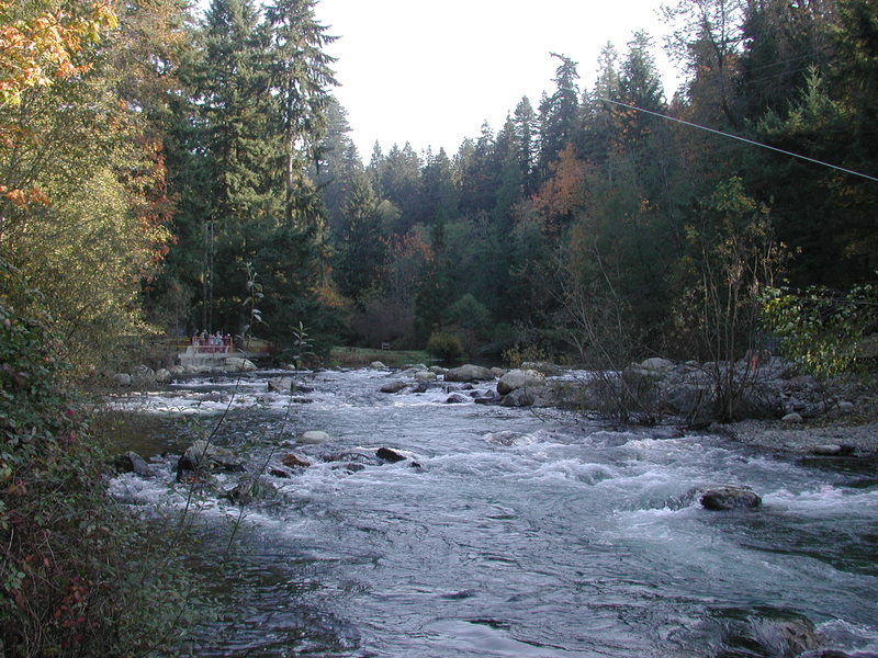
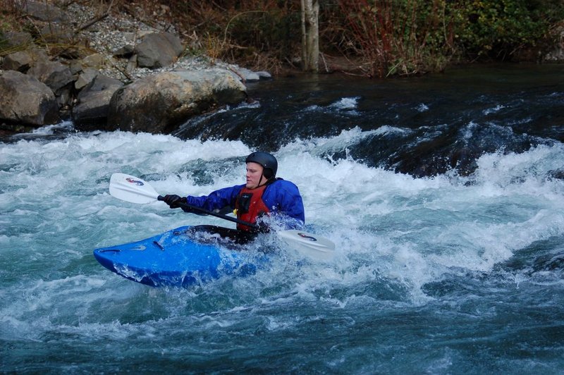
The reach between the aqueduct crossing and Landsburg bridge has been modified into a series of steps creating a nice set of rapids. The project was designed to allow fish passage, but paddlers have also realized the benefits.
Oct 26, 2002
Once the site of a nasty hydraulic, the aqueduct crossing has been modified into a series of steps creating a nice set of rapids. The project was designed to allow fish passage, but paddlers have also realized the benefits.
Mar 22, 2001
The City of Renton was required to conduct mitigation for dredging that occurs at the mouth of the river. Their mitigation was to improve spawning habitat for salmon in the upper part of the river where it’s most important. They have been and will continue to dump 1,000 cubic yards of clean gravel below the bridge on river right. This 'road' has served as a convenient access point for paddlers.
Mar 18, 2001
Annual Cedar River slalom race.
Jan 1, 1900
Running the Landsburg Bridge slalom course on the Cedar River. Not too bad for beginners to practice on a small set of rapids. Patrick, running the slalom course on the Cedar River in Landsburg.