Buckhannon
2. Tenmile to Sago
Jan 8, 2026
I ran this section four times throughout 2025 with the following level readings on the USGS gauge in Buckhannon: 7.40' (04/11), 7.95' (06/21), 8.33' (12/21 lap 1), and 8.11' (12/21 lap 2). Though the level was 0.40' higher than the listed minimum on this page, I would not want to run this section any lower than I did on 04/11. Furthermore, while the 06/21 lap supposedly had 0.55' more water than the 04/11 lap, the level for both of those laps was almost exactly the same. There were two reasons for this: 1) the gauge is 14 miles downstream from the put-in, and 2) the flow on 06/21 dropped at double the rate of the flow on 04/11. This is a somewhat long-winded way of explaining that simply looking at the gauge and seeing 7.00'-7.50' while the flow is dropping is not necessarily a guarantee that there will be enough water for a worthwhile experience. Regarding the minimum runnable flow on this section, I think it should be considered to be a) 7.00' and rising or b) 8.00' and dropping in order for one to be certain that there will be just enough water.
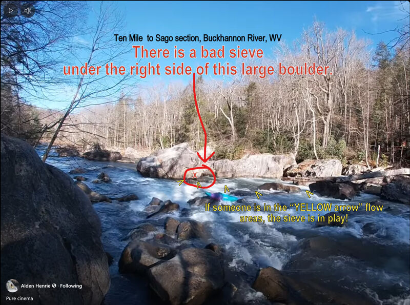
Dec 27, 2025
This rapid is near the end of the run (well upstream of the 'broken bridge').
It has a lot of F-U rocks at low/med water. Try to NOT get bumped right (yellow arrows) to avoid the hidden sieve in this class 2 rapid ... with potential serious consequences.
Nov 26, 2024
Ratings and rapid character:
This section will probably feel like class IV to paddlers new to creeking while experienced creekboaters will likely think the run should be rated III+. The major rapids are formed by large boulder piles blocking the river and have distinct horizon-lines and good pools above and below. Many rapids including some of the larger ones are formed where an island splits the river.
Flow:
I have only run this at 10.5, near the suggested cut-off of 11. At 10.5 things felt fluffy but there were plenty of eddies and still a lot of rocks hiding in the lines. I think running it above the cut-off would likely be fine, but I would say probably not on your first run. Use your judgment and scout.
Shuttle and parking
From the town of Sago drive upstream on route 30/7 Sago Rd. When the road leaves the river there is a large gravel lot. This seems like the best option for a takeout. The village of Sago does not have any public parking and the river is flat from Sago to the gravel lot so you are not missing anything by cutting off a mile from the run.
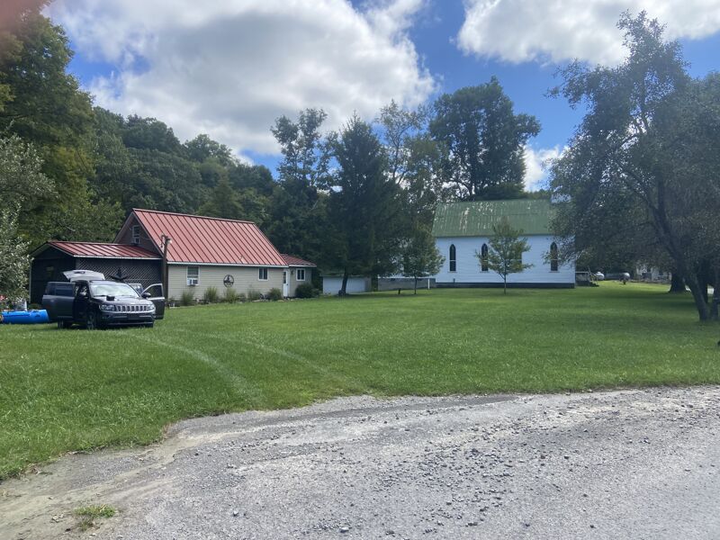
To get to Tenmile continue south on Sago rd. until you get to Big Bend Church (2.8 miles). At the Church stay left to take Big Bend Road. This is a small but well-maintained road. Any car should be able to use this route if it is not snow-covered. In 2.4 miles you will arrive in Tenmile.
Rapids in order:
Please Note- There is a lot of class II between some of the rapids listed. Also, I may have missed some rapids when I chose to go around one side of an island and not the other. I tried to align the rapid names with the photos on the AW page I have also named a few nameless rapids. I hope this description is helpful but I also hope people who know the river will add to it, and edit any mistakes.
Put in “Kamp Rippling Water,” Mile 0
In Tenmile, on river left, immediately upstream of the bridge, downstream of the church. This is a private vacation cabin. Previous trip reports say the owner allows access, but we did not speak to them on our visit. Be respectful.
Stairstep, class III, Mile 0.6
After some warm up class II you will see an obvious horizon line. The river is blocked by a pile of boulders and it splits into 2 channels. The left channel is a simple triple drop, the right channel leads to a large sieve. Scout on the left shore, the left channel sometimes holds wood and you can’t see the line from your boat.
Railroad, class III, Mile 1.2
A few nice small rapids follow before you get to Railroad, a long boulder garden with a ledge in the middle and a surf wave at the bottom just upstream of a railway bridge. At 10.5 feet this was the best wave on the river and had good eddy service. You will not be able to see the railroad bridge from the start of the rapid which is about ¼ mile long. At lower water, it will likely feel like 2 distinct rapids.
No name Boulder Garden, Class III, Mile 1.9
The next mile has plenty of fun class II-III boogie water. Nothing here warrants a scout, there is at least one class III boulder garden near the end that feels like a distinct rapid.
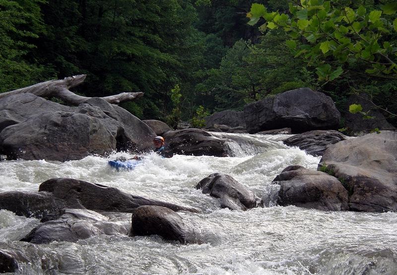
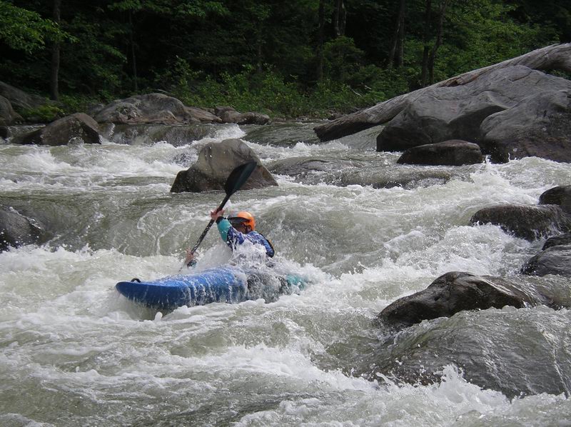
S turn, Class IV-, Mile 2
Another boulder pile rapid on the right side of an island, S turn will be obviously bigger than the rapids proceeding it, if no one in your group has run it you should probably scout. I believe the typical line is to enter on the left and S turn into the main flow at the bottom, at 10.5 feet we ran down the right side, a steep bouncy line that was probably harder than it needed to be.
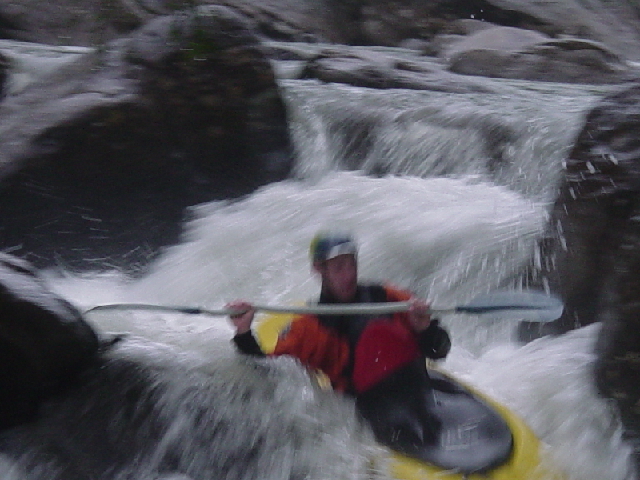
The Wall, Class IV-, Mile 2.25
After a nice pool the river again splits around an island. The right channel has almost all the flow and holds The Wall rapid. Scout on the right. Enter in one of the slots river right and end on the extreme left next to a large boulder (the namesake wall). There is a pile of boulders in the bottom middle that looks like it has pin potential.
Cabin, Class II+, Mile 2.6
A read-and-run boulder garden. There is a cabin at the bottom on river left.
Pauls Ledge, Class III, Mile 3
You probably won’t know you're in this rapid until you realize you're about to drop off a river-wide ledge. It feels like much of the boogie water on the river but has a 3-foot drop into a hole at the bottom. At 10.5 the hole was fluffy, not a problem, just surprising.
Wash Board, Class III-, Mile 3.1
A rocky rapid run straight down the middle. Not much harder than the boogie water immediately upstream of it, but its horizon line marks it as a distinct rapid.
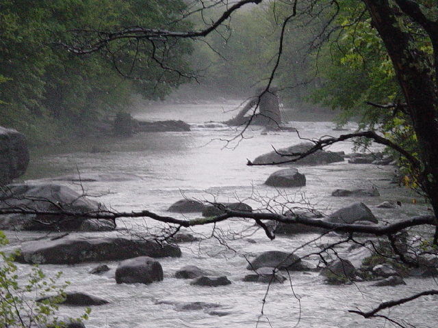
Broken Bridge, Mile 3.6
The rubble from an old bridge forms a small rapid. The drop is small and easy but use caution, there is a lot of rebar in the river here.
Lowhead Dam, Mile 4.1
The river splits around an island with the left side blocked by a small low-head dam. It's visible from upstream.
Take out, Mile 4.1
The upper take-out. River left.
Aug 31, 2023
We ran it at around 8 feet and dropping. A couple more feet of water would have been ideal, but it was a great run! Probably best for kayaking but we r2ed in a 9' hyside and had a great time. The guage says that 11.9 ft is higher than recommended but we all agreed that would have been perfect and 8 ft actually felt like the lower end.
Everything was easily scoutable and straightforward for the most part.
The shuttle description is good except for a couple innacuracies: The Kamp Ripple or whatever is on river left not right and you don't cross the bridge.
Mar 17, 2007
The first drop below Ten Mile has bad sieves to the center and right (i.e. no passable channel, river goes under rocks). Stay left!!! Scout to be sure. This is a very pleasant run, but keep an eye out for logs. The shuttle is easy.
May 26, 2005
Karen runs a ledge in the bottom one mile of the Buckhannon. This ledge can sneak up on you!
Morresa runs the left side of the first significant rapid to avoid the nasty sieve on the right.
May 6, 2005
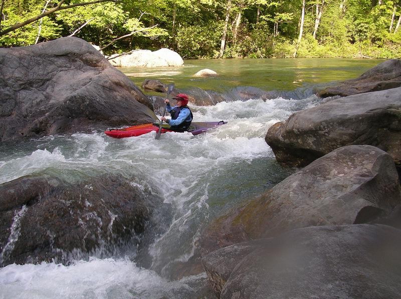
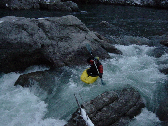
Paul riding his stern after punching the last ledge in the bottom third of S-turn(picture captured from video).
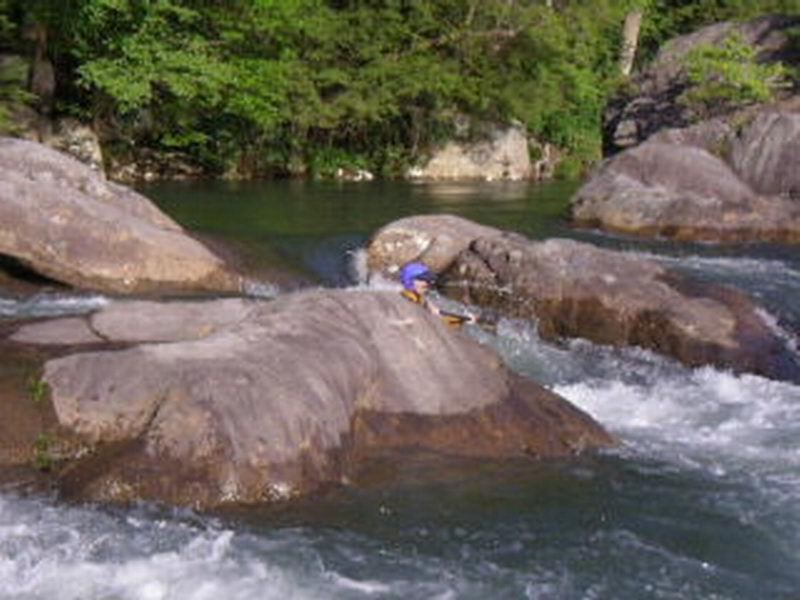
Martin entering a slot at the top river right of 'The Wall' Rapid. The current runs right to left through slots and over rocks ending near a very large rock at the bottom (known as 'the wall').
Martin in the middle of 'The Wall' rapid. He needs to go right or left of the center rock next(photo captured from video).
Martin does not make his decision fast enough and broaches on the rock in the center of the main flow at 'The Wall' just before the bottom of the run(photo captured from video).
May 7, 2004
Paul entering the left to center middle route at 'S-turn' rapid which is the second big drop, about one mile from the first big rapid (the one with the right sieve).
Paul punching the last ledge near the bottom of S-turn. Now he just needs to avoid a broaching rock just downstream on the left.
May 7, 2004
Paul entering the left to center middle route at 'S-turn' rapid which is the second big drop, about one mile from the first big rapid (the one with the right sieve).
Click here for the full-sized version of this photo.
May 23, 2003
Although no apparent rapids, scouting is HIGHLY recommended. River bed is LOADED with tangled cable and lots of upstream facing re-bar
May 23, 2003
River left before upper railroad. Scouting is recommended before running. Photo is of the right slot. Far river right usually has hidden strainers although is runnable at higher levels.
Oct 18, 2002
Top, river left of Entrance Rapid. A very nice initiation to the Buckhannon river. Not very technical although should be scouted for the typical creek strainers
May 9, 2002
We ran this on 5/4/2002 at 8.4 and falling slowly on the Buckhannon gauge. Cannot believe this stretch does not get more traffic. It's delightful and interesting and scenic and remote.
SHUTTLE. easier than the book says. It is easy to find Sago. We parked upstream of the bridge in Sago about a mile where the road widened and there was a clear place to park. From there we continued upstream and the paved road turned away from the river and went through a coal mine and breaking operation. Continue on this paved road up and up until you come to Big Bend Church on your left. At this point you can turn to the right down a very good looking gravel road (WRONG!!) or you can go straight ahead down what looks like a little traveled dirt road (CORRECTO MUNDO!!). This road starts downhill almost immediately and after about 2-3 miles...you're in Tenmile. The road is fine to travel and unless there is a washout or something, any vehicle can travel it. (We had a Ford Van and later a Plymouth Reliant.) Total time about 15 minutes or less. As of 5/4/2002 we were told by a local to park and put in on river right upstream of the bridge. According to a resident, this property has been purchased by the state of WV. On 5/4/2002 the property still had a sign on it proclaiming it to be 'Kamp Rippling Waters'.
THE RIVER: guidebook has it about right. At the level we ran it at (using Nantahala Falls as reference rapid at class III-), we four thought that about 4-5 rapids deserved a rating (depending on the rapid) from about a class III- to a III+ or maybe IV- ratings. All scoutable and walkable, although none of us walked any. None of them surprised us. The river is approximately pool and drop in character. Don't let the gradient in the guide book of 53 fpm fool you. If one takes out the flat last mile then the gradient goes to about 70-75 fpm and that is about what it felt like. If you like the Upper Meadow at about 6 feet or the Middle Fork at 3.5-4.5, try this one at 7.0-9.0 some day. I predict a pleasant surprise.