McCloud
McCloud Dam to Shasta Reservoir(Lower McCloud)
Oct 30, 2022
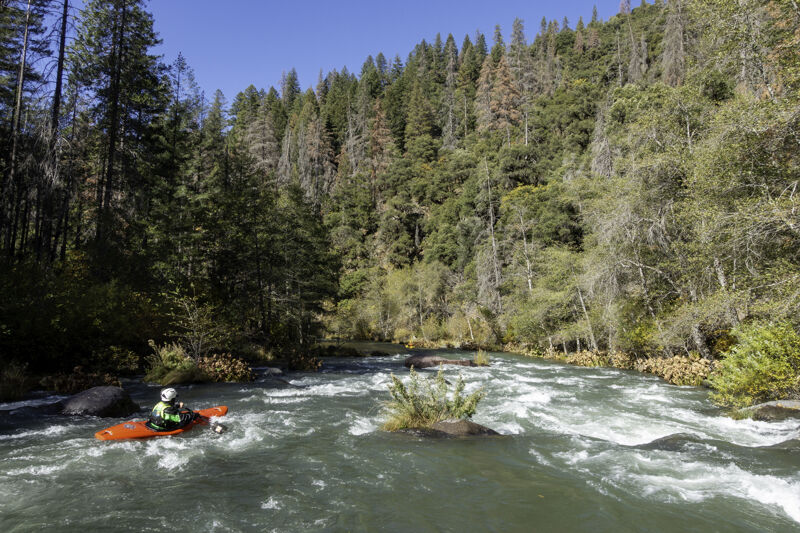
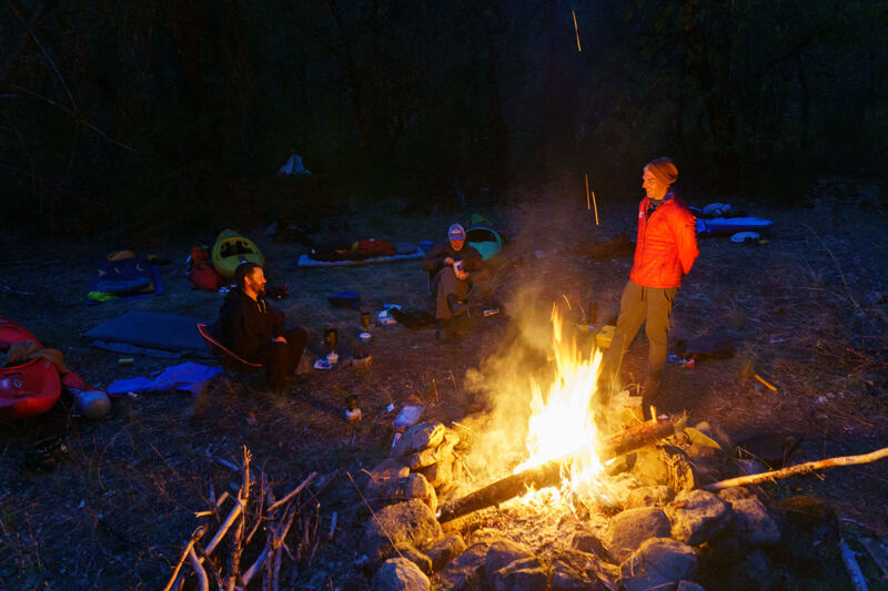
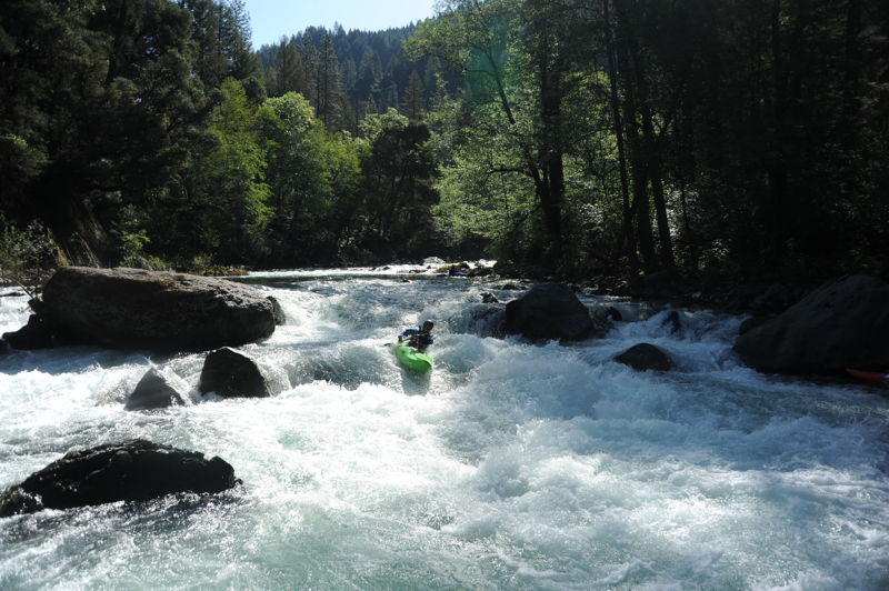
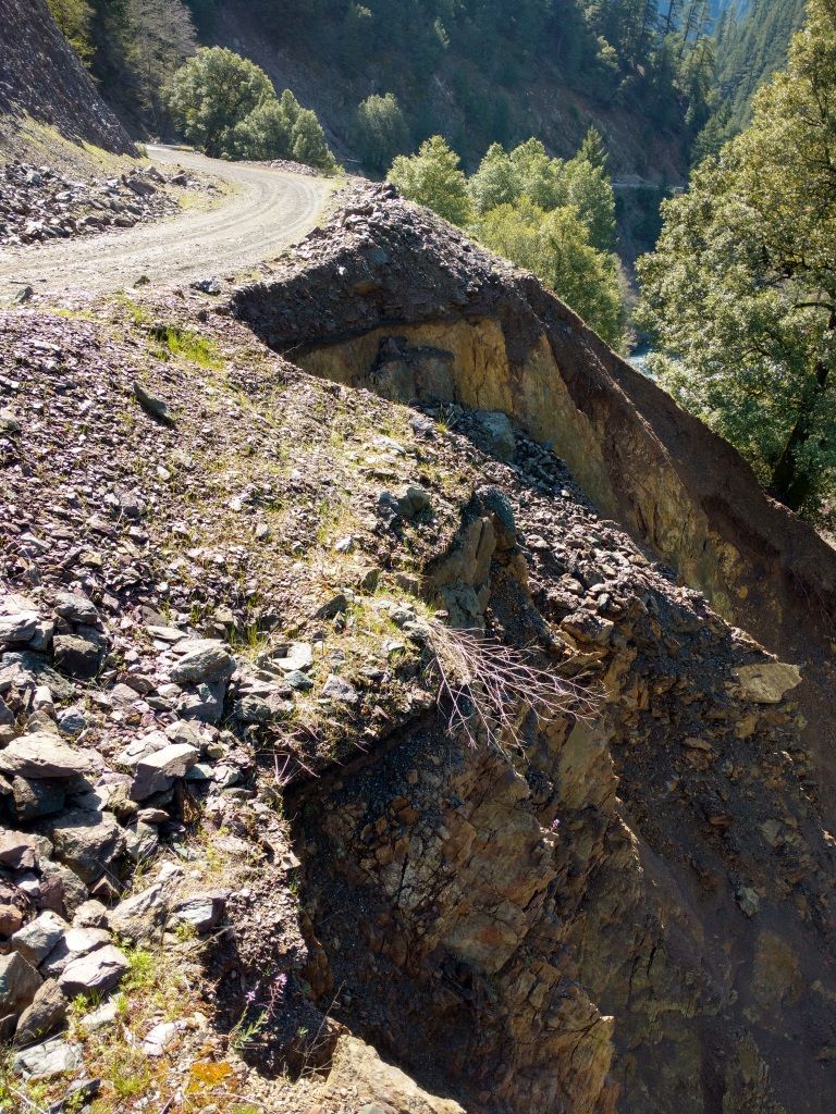
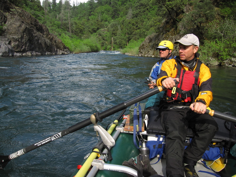
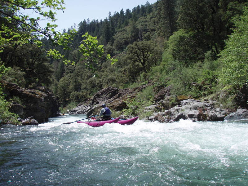
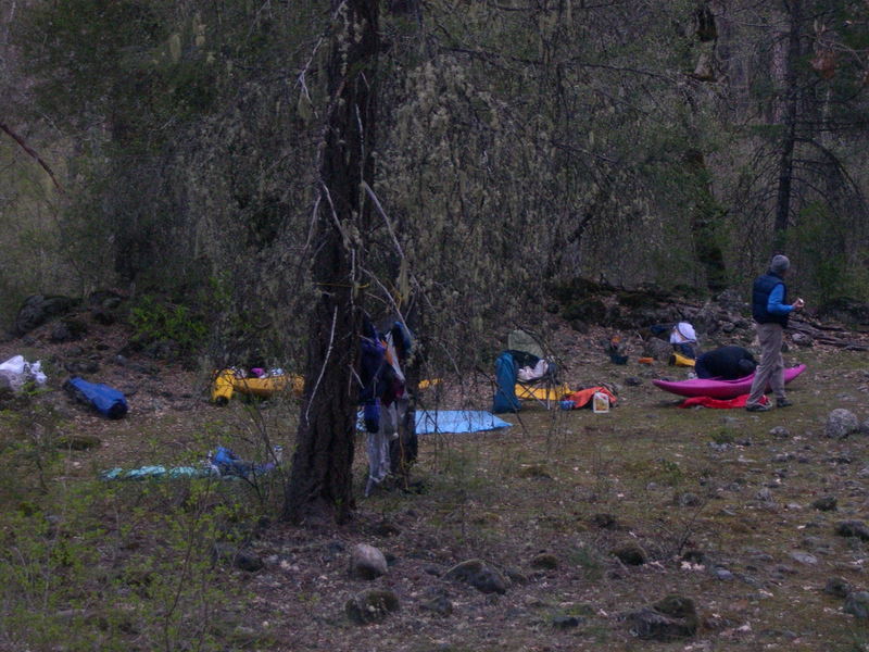
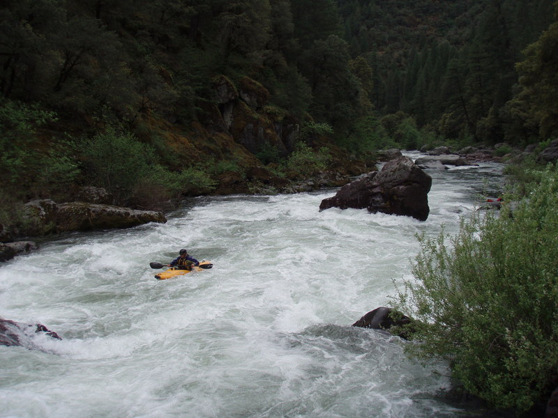
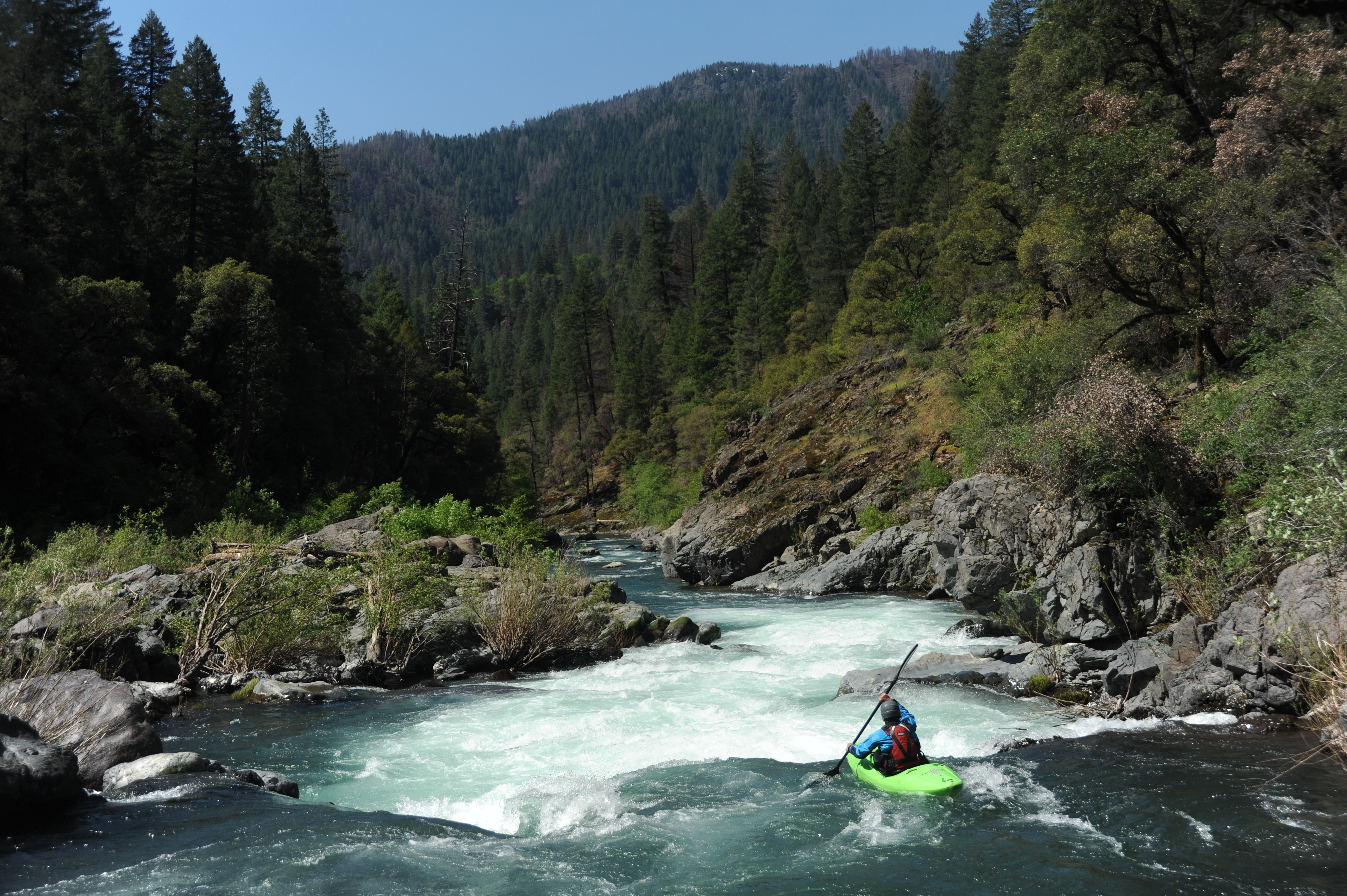
The lower McCloud hadn't run since the big flows of early 2019 so when PG\&E's powerhouse maintenance meant they weren't diverting 2/3 of the flow out of the river for a couple weeks, five of us immediately jumped on the opportunity to paddle it on a glorious fall weekend (10/29 - 10/30/2022) at approximately 530 cfs (Ah-Di-Nah gage). Unfortunately, we found out that PG\&E was also doing road maintenance below McCloud Dam where their spillway has been eroding the hillside. Tipped off by security cameras, their security patrol showed up minutes after we arrived at the dam and told us we wouldn't be allowed to walk past their barricade to get to the river. The only reason for this was because they were concerned, somewhat rightly, that their road work posed a risk of rocks falling into the river below. Easy to fix, we said, all you have to do is give us a five minute pause on the road work and we'll paddle by and be gone. Nope, they said, 'go paddle the North Fork Feather if you want whitewater.' That's like being told to go to McDonald's when you're at the doorstep of a steakhouse; they don't get it or care. So we drove another 45 minutes to put in at Ah-Di-Nah Campground and missed four miles of some of the best whitewater on the river. So it went. We had sunny fall skies, a shady canyon, and a warm fire at the only campsite in the river canyon. At the end of October, expect the river to be in shade more often than in sun. Turns out that the entire canyon is private land, except one tiny sliver of national forest, is owned by a handful of wealthy fishing clubs and one nature preserve. Because the California constitution guarantees your right to travel down a river, a boat is the only legal means by which to see the whole canyon. We camped at the only camp spot on public land on the entire run, located at the mouth of Claiborne Creek on river left just downstream of the bridge to the McCloud River Club. A couple guides from the club paid us a friendly visit after dark, two visits, actually. The first was to ask us to put out our campfire due to the national forest fire restrictions. Those restrictions had actually just been lifted and fires were allowed and conditions safe, so we let them know that and referred them to the [Shasta-Trinity National Forest website](https://www.fs.usda.gov/detailfull/stnf/alerts-notices) to see the proof. They left but returned a half hour later. We were sure they were coming back about the fire but, instead, they thanked us for being informed about the status of fire restrictions and brought us some cold beer and a bucket. Thanks, guys! The McCloud is famous for being electric turquoise and super clear, but now it is a silty green/brown and you can't see into the water at all. This is its climate change color and the silt comes from mudslides on Mount Shasta that are triggering as its glaciers surge and collapse (up aptly named Mud Creek). It's been this color for two years and is possibly just its new hue for the era. Still good for boating, maybe not so good for angling. This part of the McCloud is also different from its upstream sections because rather than flowing through the Cascade Range with its sharp basaltic rock, it flows through the older Klamath Mountains with its smooth metasedimentary rock that is much more boat friendly. By another quirk, there isn't gold in this far eastern edge of the Klamath Mountains, so the river hasn't been mined like most of the the others. A true gem! The rapids were great and we all agreed that we wouldn't want much lower flows than we had. There was some pinballing involved in kayaking the run but it wasn't enough to detract from the enjoyment of the river. Even small rafts should expect to get hung up and stuck in places at these lower flows, and it would be a challenge to get a medium or large raft down the run; pack light in any raft. There were a couple obstructions to be aware of. We encountered two river-wide trees on the first half of our first day between Ah-Di-Nah and the Claiborne Creek camp. The first can be paddled around on river left by kayaks but not anything larger. I recall the second tree had some sharp staubs that would make it harder to get an inflatable boat over and a portage may be necessary. We paddled over a tree in swift current on the second day not far below the Claiborne Creek camp. It had just enough water to scrape a kayak over without much worry at 575 cfs. On the lower reach of the second day we also encountered a rope across the river at chest level (easy to lift and paddle under) and a temporary bridge that was placed just a bit higher than kayaker head level; this could be problematic for rafts and tall boats, especially if the water is comes up from the 575-600 cfs we had but there's a good line of sight to it from above. See the photos in this report. Clearly at these lower flows, the river is best suited to kayak-size crafts and only the smallest rafts. A mini cat R2 setup might be the best raft to take.
Oct 30, 2022
A rare fall run down the McCloud River as natural flows stay in the riverbed instead of being diverted into the Pit River. Warm weather for the season, a timely ending to the fire ban and a great crew make for a nice weekend.
Flows are projected to continue until November ~12. PG&E is not allowing access at the base of the dam or Ash Creek, so Ah-Di-Na Campground is where we put on.
May 4, 2019
An overnight trip on the McCloud River to Shasta Reservoir with Dave Steindorf, Ben Ellis, Gary Hull, and Tom O'Keefe. We arranged for a ride to the put-in and got on the water just before 1pm on Saturday. We camped overnight and had a great day of whitewater on Sunday. We arranged for a pontoon boat pick up on Shasta Reservoir around 2pm on Sunday and took about 90 minutes to motor down to a boat ramp on the west side of the McCloud arm of the reservoir. It was a great trip but look out for the poison oak if you get out of your boat.
Apr 18, 2018
Illustration of project-related effects to roads providing access to the public and project facilities. Lack of maintenance for forest roads is affecting access and in the case of the road below the McCloud Dam spillway, the spillway itself is oriented directly towards the road and undermining the road.
Oct 3, 2011
Jun 15, 2011
On June 10, 2011, PG&E reported
Based on the current snowpack condition, increasing air temperature, and increasing inflow conditions into McCloud Reservoir, PG&E anticipates that the spill magnitude at McCloud Dam will continue to increase steadily over the next several days, and possibly weeks depending on the long term weather trend.
May 16, 2011
May 20, 2009
Disagree a bit with your estimation. The key to this run is getting it when the dam is spilling or the diversion is shut off. I got on this run 3 times in 08; once in may when the flow at Shasta was 1,300cfs (scheduled release) and twice in sept. (PG&E maint) at apprx 900cfs. and the rapids flew by esp. at the top, covered the 1st ten miles in less then 2 hours (class 3+ boulder gardens) the middle 6 miles in 2 hours (class 3+/4 boulder gardens & mini gorges with a couple of holes) and the last 5 in two and a half (class three boulder gardens with longer pools with one a step up {steeper boulder garden on a left bend} Good play as well if you dare to bring a play boat. This run needs a recreatioal release!
Apr 21, 2009
Here is a write-up of our recent trip on the lower McCloud at about 850 cfs inflow to Shasta. Two kayaks and a small cat. Feel free to post up to the river site. Neil Nikirk
LOWER McCLOUD RIVER – The Good, the Bad, and the Ugly (My apologies to Clint!)
The GOOD
Lots of nice technical Class IV drops
Plenty of Class III action
Beautiful clear water
Nice mid-elevation scenery
Mini-canyon with cool rocks
Great fishing (I hear)
Nobody else on the river
Wilderness feel
The BAD
Logs here and there
Paddle, paddle, paddle across SLOW pools in one section (between Class II rock gardens)
Private land everywhere, one place to camp (legally)
Irate landowners (I hear)
The UGLY
A couple of Class V’s with consequences for a missed move (maybe DEATH!)
Killer shuttle (2 hours one way)
This was a 3 boat trip, Scott and Mike in kayaks and me in the 13 foot cat. We met at the takeout about 11:00 on Saturday, swapped gear and headed for the put-in (2 hours away). Flow at the bottom was probably around 800 cfs. We planned on putting in at Ah-Di-Na Campground, but the road was blocked by a few leftover snow drifts, so we put in upstream at Ash Creek. This is at least two miles above Ah-Di-Na. Mike (the McCloud veteran from a run 15 years ago) had never done this section. Flow at the put-in was probably around 300 and the river was full of boulders. Thank goodness Ash Creek was just downstream adding to the flow! This section down to Ah-Di-Na was reported to have 6-7 good drops, mostly Class IV, one portageable Class V and a bunch of Class III. That’s a pretty good report for this first 2 ½ miles. We portaged one big drop with no clear route, at least for my cat. We also had to duck under one log and run a chute under another one in a Class IV rapid.
Below Ah-Di-Na, the river is mostly class II –III boulder gardens with long, slow pools between. Lots of rowing exercise, we were pretty tired when we made it to Claiborne Creek where we could camp on the small piece of public land. Creeks pour in all along, so we probably had 500-600 cfs at this point. This was probably the least interesting stretch on the river and I hoped it wouldn’t continue the next day.
The next day starts off with McCloud Swim Team a relatively easy Class IV boulder garden and narrow drop at the bottom. Nobody joined the club today! Some interesting rapids downstream including one with a tight chute that curved left (hard left). Just barely wide enough for the cat (6 feet) and almost a flip. More Class IV rapids await downstream like Werner’s Profit and Double Drop. The kayakers portaged at least part of Double Drop, but I ran it clean over the fan rock on the left. Fun rapid! More class III and then Tuna Falls. A nasty looking entry drop/hole and then a big undercut rock at the bottom. The right side of the rock would be OK for kayaks at this level, but too tight for the cat. We all opted to portage. The kayaks to below the last drop; I put in after the entry and ran the left route on the final drop around the undercut rock. If you were swimming in front of the rock – DEATH.
About a mile downstream of Tuna Falls is the last big rapid Valhalla (aka The Reagan Years), Class IV+ with a diagonal move to avoid a BIG fan rock left of center. Great photo op! The rapids ease below this one to Class II and III. One Class III boulder garden has a nice looking center chute over about a 4 foot drop. Scott gave it a try, got stern squirted and sucked back into the heavy reversal. He ended up swimming and the kayak stayed maybe 5 minutes before coming out on its own. Thank goodness the boat came out, that’s where the shuttle car keys were! The scenery below Tuna Falls is great as the river cuts some mini-gorges through slick limestone and the riparian corridor has many oak trees mixed with the firs and a few cedars. Pretty soon we were at the take out on Shasta Reservoir.
All things considered, a great trip. Would I do it again? Maybe… If the shuttle wasn’t so long and we could eliminate the flatter water in the center, and find more places to camp and… This would be a great 1-day run if you could get permission to launch at the McCloud Club at Claiborne Creek. Wonder if we should inquire? Rumor has it, the owners are none to friendly towards boaters. But if cash was involved for access and shuttle? Who knows? This is definitely a river for small boats; kayaks and IKs would be great, as would 10-12 foot paddle rafts. My 13 foot cat was about as large a boat as you could reasonably expect to get down on 800 cfs into the lake. This boat is set up narrow at just under 6 feet wide and some of the must run slots were just a bit narrower!
Apr 13, 2009
This was a 3 boat trip, Scott and Mike in kayaks and me in the 13 foot cat. We met at the takeout about 11:00 on Saturday, swapped gear and headed for the put-in (2 hours away). Flow at the bottom was probably around 800 cfs. We planned on putting in at Ah-Di-Na Campground, but the road was blocked by a few leftover snow drifts, so we put in upstream at Ash Camp. This is at least two miles above Ah-Di-Na. Mike (the McCloud veteran from a run 15 years ago) had never done this section. Flow at the put-in was probably around 300 and the river was full of boulders.
Thank goodness a good sized creek was just downstream adding to the flow! This section down to Ah-Di-Na was reported to have 6-7 good drops, mostly Class IV, one portageable Class V and a bunch of Class III. That’s a pretty good report for this first 2 ½ miles. We portaged one big drop (amphitheater) with no clear route, at least for my cat. We also had to duck under one log and run a chute under another one in a Class IV rapid.
Below Ah-Di-Na, the river is mostly class II –III boulder gardens with long, slow pools between. Lots of rowing exercise, we were pretty tired when we made it to Claiborne Creek where we could camp on the small piece of public land. Creeks pour in all along, so we probably had 500-600 cfs at this point. This was probably the least interesting stretch on the river and I hoped it wouldn’t continue the next day.
The next day starts off with McCloud Swim Team a relatively easy Class IV boulder garden and narrow drop at the bottom. Nobody joined the club today! Some interesting rapids downstream including one with a tight chute that curved left (hard left). Just barely wide enough for the cat (6 feet) and almost a flip. More Class IV rapids await downstream like Werner’s Profit and Double Drop. The kayakers portaged at least part of Double Drop, but I ran it clean over the fan rock on the left. Fun rapid! More class III and then Tuna Falls. A nasty looking entry drop/hole and then a big undercut rock at the bottom. The right side of the rock would be OK for kayaks at this level, but too tight for the cat. We all opted to portage. The kayaks to below the last drop; I put in after the entry and ran the left route on the final drop around the undercut rock. If you were swimming in front of the rock – DEATH.
About a mile downstream of Tuna Falls is the last big rapid Valhalla (aka The Reagan Years), Class IV+ with a diagonal move to avoid a BIG fan rock left of center. Great photo op! The rapids ease below this one to Class II and III. One Class III boulder garden has a nice looking center chute over about a 4 foot drop. Scott gave it a try, got stern squirted and sucked back into the heavy reversal. He ended up swimming and the kayak stayed maybe 5 minutes before coming out on its own. Thank goodness the boat came out, that’s where the shuttle car keys were! The scenery below Tuna Falls is great as the river cuts some mini-gorges through slick limestone and the riparian corridor has many oak trees mixed with the firs and a few cedars. Pretty soon we were at the take out on Shasta Reservoir.
May 9, 2008