Blue
Hwy 7 to Cheadle Falls near Wapanucka (9.5 miles)
Nov 4, 2019
The gauge used for this run should be the one near Connerville, though runnable numbers are different: https://waterdata.usgs.gov/ok/nwis/uv/?site\_no=07332390&PARAmeter\_cd=00065,00060
We ran this section last week at 1250 cfs (on the gauge above), flood stage. It was a blast, with typical flood obstacles.
The gauge down river currently used for this run spiked to 3500 cfs +/- a while later, so I assume this is how levels could somewhat be compaired.
Fun run!
Sep 18, 2009
Blue River is better done in pieces. Find a good hole and work it. To try paddle the river over several miles might be really disappointing.
Jul 6, 2007
We ran the blue river May 15th 2007 @120cfs on the johnston county gauge. The first 2 miles werent too bad except it was really scratchy but the last 2 miles to the camp ground and it sucked. We got bush wacked and it took 2 hours longer to run the river. Its was too much of a hassle to enjoy, but whatever. There needs to be more public access point on the river to run selected sections.
Jun 2, 2007
I wouldn't listen too much to the commentary by the paddler who advised skipping this stretch. They clearly didn't hit it at the right flow. Catch this at the right flows and it is a great ride with lots of drops with pools in between. The guage is way downstream so I watch the rainfall upstream at Roff. It rises quickly and drops almost as fast. I drive down from OKC whenever I see at least 2.0 inches of rainfall. I run it about 5-8 times a year.
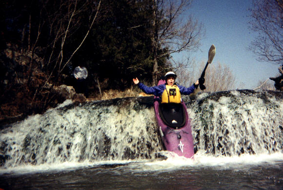
There can be lots of timber in the stream and scouting from the banks in nearly impossible. Know the river before you jump on it at high levels unless you are skilled. Generally the best rides are on river left. Big Falls and Cheadle Falls are downriver from the state park but can be well worth the paddle at higher water levels. Big Falls is a series of small falls one after another. It is full of trees but there are some great runs thru them. Cheadle is a 10 foot drop. Run it middle river. There is a nice wave train that follows a S curve right to the drop. Get out of the river at the road right below because there is nothing left but flat water after the Falls.
A good indicator of the flow is to look upstream from the Highway 7 bridge (where I usually put in) and see if the drops are completely underwater. If you see timber and rocks sticking up then you may have some knuckle dragging---good time to learn the stream but not the best paddling.
The water has a very high sulpher content and can smell quite bad during the first high water or two each spring.
May 16, 2006
On 5/7/06, a group of 4 paddlers ran this section - here's our feedback...
In Short: When this is running, there's other stuff running. Go run that.
Also - one of the boaters swallowed some water and had severe intestinal problems requiring a visit to the doctor.
1. GAUGE INNACURACY. If anyone knows the streamkeeper, it would be great if they'd change the minimum flow of 350 cfs. The gauge linked to this section is 5 to 10 miles down river **from the 9.5 mile Hwy 7 to Cheadle Rd takeout**. Thus, the CFS ratings you're getting are maybe an hour or so old AND you might be missing some tributaries.
2. KNUCKLE DRAG. We put on at about 1pm on 5/7/06 and knuckled it all the way down. This is just past an almost 2000 cfs peak on the linked gauge. Maybe we floated two or three drops and the pools in between. Here's the USGS data for that day using the linked gauge:
http://waterdata.usgs.gov/nwis/dv?cb\_00060=on&format=gif\_default&begin\_date=2006-05-06&end\_date=2006-05-08&site\_no=07332500&referred\_module=sw
3. CHANNELIZED. The biggest reason why you knuckle this run is the amount of islands and channels in the river. At good flows (see below) you'd be looking at almost no eddy service above the drops and thus high chances of splitting up the group. The islands are overgrown with trees and shrubbery.
EDUCATED GUESS SUGGESTED MIN ON THE LINKED GAUGE: 1700 CFS
If you're local, you might be able to paddle a very short section by walking up from the river right WMA camp ground that marks the 3.5 mile from Hwy 7 section.
Oklahoma has some hidden runs, we're gonna continue looking.