Devils
Pleasant Road to Hwy.147 (4 miles)
| Difficulty | II-III(IV) |
| Length | 3.7 mi |
| Avg Gradient | 26 fpm |
| Gauge | Devils River |
| Flow Rate as of 35 minutes | 6 cfsbelow recommended |
| Reach Info Last Updated | March 4, 2025 |
Quick Facts:
Location: Maribel, midway NW of Two Rivers and SE of Green Bay.
Run Length: 1-mile access paddle, 0.6 miles of rapids on Devils River, plus up to 2.4 miles paddle-out on Neshota/West Twin.
Shuttle Length: 3.8 miles
Character: A gentle stream meandering through America's Dairyland changes character after passing under the interstate. As the riverbed turns to bedrock, a falls (three quick ledges) and sloping bedrock make a busy half-mile.
Drainage area (at confluence with Neshota/West Twin): 36.3 square miles
Put-in is approximately 721' elevation.
Confluence (Devils/Neshota) is approximately 647' elevation.
Take-out is approximately 619' elevation.
Thus total elevation change is approximately 102'.
Gradient for just Devils River is approximately 46 FPM. The 'action' is 50' of drop in a half-mile, for an effective gradient of 100 FPM.
Gradient for the included portion of the run on Neshota/West Twin River is approximately 14 FPM.
Nearby ('companion') runs (with drainages, for comparison): Bower Creek (14.8 sq.mi.), Baird Creek (15.7 sq.mi.), School Creek (15 sq.mi.), Neshota/West Twin (43 sq.mi.).
(Since these are all small drainages and relatively similar size/nature, they are likely to all run at same time. Also, since they all short runs, it is very possible to do a 'daily double', triple, or quad!)
General Overview
The 1-mile access paddle for this reach consists of flat but flowing water, with occasional riffles and rips. One should expect numerous snags which
...
To reiterate from the body of the description: if you can find the proprietors at home, you may be able to gain access from the campground, thereby eliminating the access paddle. However, recently I have heard second-/third-hand info suggesting they are not boater-friendly, and are likely to protest your presence (due to liability and other concerns) to scout or portage. Thus, we generally urge keeping as low-profile a presence as possible when scouting/portaging this area. (Keep as quiet as possible, keep as near the river as possible, and do not linger any more than necessary!) I have never had a problem (never been confronted) here, but, then, I have never attempted to boat this during summer, when campground is likely to be full and active.
Remnants of a former dam flank the river at the brink of this 'falls'. The river spills down a stairstep of bedrock ledges into a hole (at higher flows, anyway), sheeting across a short (flowing) pool before dropping off another short ledge (into a potentially sticky-looking hole). At low-to-moderate flows, this may rate class II+ or III. At moderate-to-high flows, this will be class IV (and a likely portage for many boaters)!
Downstream of the main ledge sequence, you will find a very busy stretch of dells (most likely with a lot of overhanging cedars and other shoreline vegetation to complicate navigation) before the banks open up and the river widens a bit.
As you head toward the County Road R, this small river spreads wider across shallow bedrock, and you will probably 'grunge out' a bit (unless you have a quite high flow). Numerous shallow waves will form through here, but none have sufficient depth (at almost any reasonable flow) to allow enough paddle strokes to catch and surf. Passing the bridge, the river heads to the right, and a fine series of ledges will form some decent waves. (There may be some play right in the back yard of a nice home.) A bit more boulder-bed scrambling will bring you to the confluence with the Neshota River, where the combined flow is now the West Twin River.
This is not on Devils River, but is a 'carry-up' from the confluence of Devils River and the Neshota River (whereupon both cease to exist, and they become the West Twin -- one of two rivers that flow into the city of Two Rivers, WI). Looking just upstream of the confluence, on the Neshota River, you will see a fine set of ledge/waves. Many boaters will find it worthwhile to carry up to run this fine sequence.
The near shore (river-left of the Devils River, river-right of Neshota River) is privately owned, with a cabin/house present. While the other shore is also privately owned, it is wooded with no home and yard, thus we advise ferrying across to river-left (of the Neshota/West Twin), to carry up on that shore. This also shortens the carry a bit, since you will be carrying up the inside of a bend in the Neshota River. Be careful walking through this wooded area, as there are numerous locations with old barbed wire down on the ground. I generally recommend carrying a good ways upstream, above the bend in the river, to put in and enjoy this fine ledge sequence.
The sequence starts with a single short (~1') ledge which spans the river, and can provide some minor play when flows are adequate. It could be worth carrying up to this point just to check out, and to warm-up the play muscles before dropping into Devils Meet Ledges. The meatier action will be Devils Meet Ledges, where most repeat play is likely to be done by shorter carry-up.
Fairly immediately downstream of Hunter's Ledge, you round a bend to the left and head back toward the confluence with the Devils River. At lower flows, these will be no more than class II, offering tame play. However, when the Devils River has good boatable flows, Neshota/West Twin is likely to be running moderate-to-high, and these ledges will likely push to solid class III or better! Some of the ledge/wave/holes will allow great play or will play with you! (That is, some get a bit sticky at higher flows and may grab you for an unplanned backender or surf!) There will be some eddies and slackwater for confident experienced whitewater boaters to 'work' (and play) the rapids. Some may wish to do a short carry-up to hit the best of these a second time. They can be skirted (paddled around) by staying far right. (Scouting may be done while you are carrying up river-left shore.)
A private residence on river left has a cement slab ford of the stream which allows them to cross at low water. (When the river is at boatable flows, they make sure to park on river-right, and cross a footbridge suspended a good height over the river.) Good boatable flows should make this ford passable (by boat) with barely more than a riffle.
Most topographic maps have a 'falls' marked at this location. At all flows and all occasions which I have run this river, I have never been able to identify just what 'falls' they are talking about. There are a few spots which have some minor ripples and riffs, but do not expect (or worry about) any 'falls' (or even rapids of note) on this part of the river.
Nov 21, 2020
Grew up in Manitowoc and had driven over this river on I-43 many times. Although flows were too low for boating, my dad and I had no problem walking up to the historical building and asking permission to walk around the ledges. This was May 2017. Not sure if everyone is always that friendly but I got the impression if they let me scout then they aren't all that anti-boater...but I was just a 'photographer' that day.
Apr 22, 2017
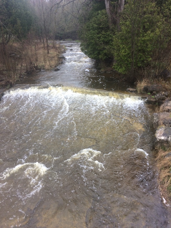
Looking upstream from the CTH.R bridge, the river is (relative to its size) wide and water sheets shallow across sloping bedrock.
Apr 22, 2017
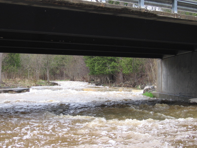
The river is wide (relative to its size) as it heads toward the CTH.R bridge. If it looks anything more than a total grunge here, you may have a decent flow for a run. The best gauge is still going up to the put-in to check depth of water over the rock in the upstream-left corner of the bridge abutment there.
