Honey Creek (Menomonee Trib)
*Check wood alert!* Honey Creek Pkwy. to Menomonee R. (1.76+2.14 miles)
Replacement of he Wisconsin Avenue bridge (in the background of the masthead photo) has essentially been completed. The parkway road and Wisconsin Avenue are open to traffic. Landscaping in the area remains to be completed, but should not impede traffic (on roads or on the water).
The cement trough has been removed from just upstream to just downstream of this bridge, the streambed has been widened, and rocks line the streambed and banks. At boatable flows, it appears the rocks should be fairly well covered, and passage should be clear.
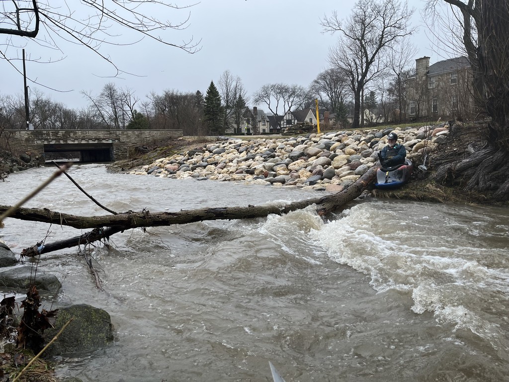
A huge tree trunk spans the creek just downstream of the bridge, just as the now rock-laden shores give way to the tree lined shores and cement trough. ****(NOTE: this is different than the one in the picture!)**** The root end lies in the flow, and will complicate (or negate) passage to the right. The trunk angles high to the upper left bank, and should be 'duckable' to river-left at most boatable flows. A second tree just downstream lies almost uniformly high overhead, and should not cause problems at any but highest flows.
Below the runout from the final jump, across from the Assisted Living Facility, a huge tree trunk spans the creek shore-to-shore, hung up high enough as to not be a problem at any but the highest flows.
At the final utility transect (just before the parkway road bridge (where the USGS gauge is), the river-right rock wall has collapsed into the river, shoreline has eroded substantially. Just upstream of the transect, smaller saplings impede passage as well. Passage on water is a tad sketchy, but doable
SCOUT BOTH OF THESE AREAS BEFORE PUTTING ON UPSTREAM! ADDITIONAL WOOD COULD HANG-UP ON THESE TREES, COMPLICATING PASSAGE!
Boaters unfamiliar with this run are strongly advised to paddle it with someone who knows the run, and knows all the places to scout before putting on.
Demolition and reconstruction of Wisconsin Avenue bridge (the one in the background in the masthead photo) will make the usual put-ins 'off limits' until that is complete! At the construction site, there are massive beams spanning the creek (as a platform for excavators to work from) making the area impassable. The parkway road is blocked to through traffic around Wisconsin Avenue (as is Wisconsin Avenue, obviously).
Uppermost put-in (until construction is complete) is just north of Portland Road, at the spot where the cement ditch ends.
As of 2025.05.14, wood spans the creek in at least two places (after the cement ditch ends). At some flows, these may be passable in your boat ('log boofing' over) but at nearly any flow, at least one is likely to be a mandatory portage!
Right after the exit from the cement ditch, logs/trees are in the water, but will likely flush and hang somewhere downstream (likely at the next mentioned location).
Immediately after passing under the parkway road, a log/tree spans SHORE-TO-SHORE. At low flow (under 135 cfs) it is a mandatory portage. At some higher flow it may be underwater enough to pass over (or it will flush out). Until it flushes, it is likely to accumulate wood.
DO NOT ATTEMPT THIS RUN WITHOUT SCOUTING THIS AREA FIRST!!! Park at the bridge just north of Portland Ave. and look downstream for the snag which should be visible from the bridge (until/unless it moves) and look upstream from the bridge. Then walk into the wooded area upstream of the bridge to take a close look at the creek (upstream of what you can see from the bridge). If it is all clear, best put-in will likely be just a bit upstream of the end of the cement ditch.
Finally, after the gabion basket wall, downstream around the bend, a tree spans very nearly shore-to-shore. The root end (to the left) lies rather low, while the upper branches lie to the right. At moderate-to-high boatable flows, it may be passable to the left (over the trunk end), but pay close attention looking for any additional hung-up wood. Otherwise, tight to the right shore, at very high flows, it may be possible to stay in your boat and get around it. At lower flows, this area will be shallow and you will have to beach for a very short portage.
DO NOT ATTEMPT THIS RUN WITHOUT SCOUTING THIS AREA FIRST!!! Park a bit west of the final bridge (where the USGS gauge is), but well before the Aurora Hospice, make your way to the riverbank for a close look at this area!
Situations change often on this creek (with every high-water event), so always check as many areas as possible before putting in anywhere on this run.
No articles