Line Creek
Slippery Rock Run
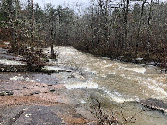
Feb 21, 2019
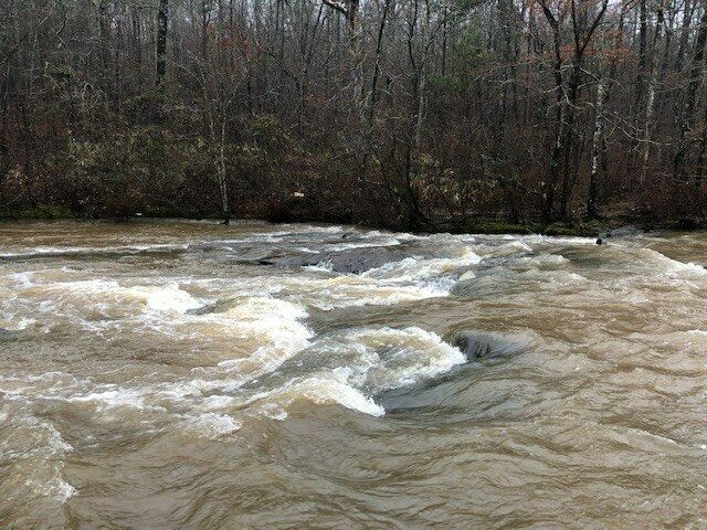
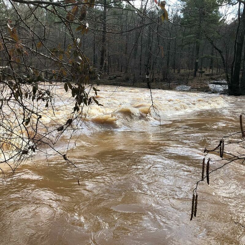
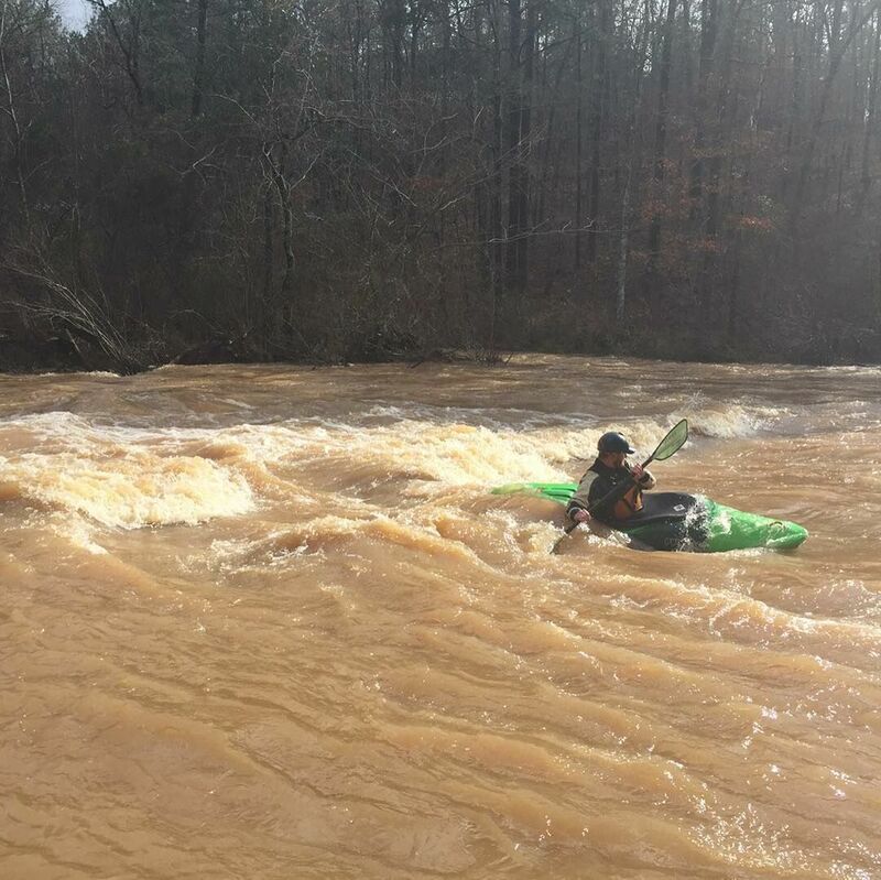
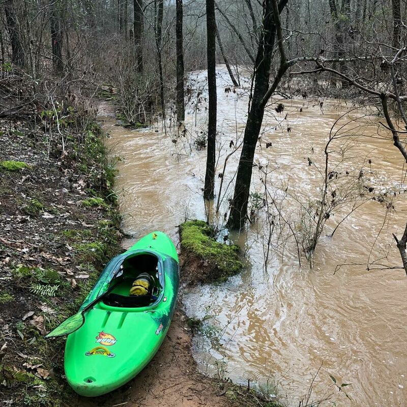
Ran Line Creek twice this week, once at 170 and once at 800 cfs. At 800 cfs, the run is quite fun, with lots of surf spots and some decent sized holes for a 2+/3- run. I scouted the length of the run ahead of time to ensure no major strainers. At 800, the river is over the banks and into the trails, reaching the mule carving at Mule Rock. The run is not hard but swimming or boating into the trees could be bad and there are not many eddies.
May 26, 2014
Attempted to paddle this yesterday at 50 cfs. I got stuck multiple times. I will try to paddle this run when the water level rises. Even though I got stuck many times, 250 cfs or higher would make this a great run. Just watch out for the tree in the middle of the run.
May 9, 2011
Went to paddle this on 4/29/11 (gauge reading 293 CFS) and was skunked. It was about 6' lower than when we ran it before (gauge reading 230 cfs). Met some other paddlers at the play wave and they suggested using the gauge at GA-54 (02344605). This gauge looks like it is a better indicator of the actual flow (it is right at the top of the run, while the gauge AW is using is about 7 miles downstream of the run).
Apr 1, 2011
Paddled this yesterday @ 230 CFS with Phillip Shellnut & Scott Tolar. 230 CFS is now my minimum, and I'd like to see another few inches of water, so I'm thinking 280-300 CFS is a good level. There is a nice glassy wave right below where the tree is across. You still cannot get through the passage at the right of the island @ 230 CFS without having to get out of your boat. The hole at the bottom of the last rapid was a fun surf. The takeout has a small beach that is now flagged with orange surveyor's tape.
Feb 3, 2011
Finally got to run this yesterday @ 180 cfs. Just slightly bony, but definitely runnable at this level. Here's my report:
Take trail at back of the Line Creek Nature Area parking lot down to creek. Follow the sign to the shoals (not creek trail). Put in at shoals. Putting in above this (Mule Rock, Ridge Trail, etc) is not advised as it is mostly flat water with at least two trees down across the creek. Do not get out on the river right bank for any reason - it is all private property and is heavily posted with No Trespassing signs. Water quality is ok and doesn’t stink, but is not beautiful by any measure and is brownish.
The run starts out immediately with shoals and wave trains. This is typical of the whole creek - nothing extremely exciting, but still fun for locals. At lower flows there is a mandatory portage just past the civil war bridge remnants where a pine tree blocks the majority of the creek. Here 90% of the flow goes to the river left of a small island (where the tree is blocking) and the rest goes to the right of the island. At higher flows there may be enough water going to the river right of the island. I tried going right of the island at 180 cfs and ended up having to carry my boat over rocks.
Surfable waves abound all down the creek. The last and largest rapid is right as the creek bends to the left. I guess this is where the play wave is, as there was a great surfable hole at the bottom of the slide on river left. If I could play in it at 180 cfs, I imagine it can get pretty stout when the flow is really up. After the last rapid, the river continues to bend to the left then straightens out - nothing but flat water from here on down. I took out about 150 yards or so past the last rapid on river left - there was a tree with what looks like a decent place to pull a boat up. The trail that follows the entire run is right there - continue to walk downstream about 30 yards and the trail up to Plantain Terrace is marked with surveyor’s tape on your left. The trail is kind of steep, and it dumps out in a wooded area between some houses in a neighborhood. I’m not sure how cool the folks in the neighborhood are about leaving a vehicle there, so I had my wife come pick me up when I finished the run.
Shuttle is 5 minutes. The run takes about 30 minutes if you just run it.
Jan 4, 2011
The takeout trail that leads to Plantain Terrace is marked with pink / orange tape now - I checked it out yesterday.
Jul 29, 2010
Its not too far of a hike back to the put in. About 1 mile. The only problems are the slippery rocks the whole way!
May 22, 2010
So I went and scoped out the creek last night. The first thing I did was go check out the take-out on Stallings Road. Unfortunately, the entrance to Stallings Road on McIntosh Trail is blocked by a locked gate and about 10 'No Trespassing' signs. It looks more like a trail instead of a road - I don't think a car's been down it in years. So in my opinion, this take-out is out of the question for use. If you wanted to still boat down to this take-out and hike to the road (McIntosh Trail), Google Earth says it's about 0.65 miles from the creek to the road.
Next, I didn't walk much of the trail of the nature preserve, but did walk down to look at the Shoals, and as the comment below says, there is a creek-wide pine tree down (there is actually a picture of this on Google Earth). As two comments below says, when the water is up, it might be skirtable on far river right, if there is enough water going to the other side of the small island that the top of the tree is on.
As for the take-out in the neighborhood that Mark Hicks mentioned - the only place I could see that being feasible is on Plantain Terrace, about 500-600 yards on the right, after you make the left from Terra Verte. There is a space of about 4 lots with no houses, and the creek comes relatively close to that road in that spot. But I saw no trail from the car. If someone could confirm or deny this is the location, that would be great.
As for alternate take-outs besides Stallings Road, my only thoughts are to go all the way down to the bridge at Rockaway Road, or if you have a somewhat-offroad vehicle, there is a neighborhood under development off Rockaway (Heritage Point Parkway), and it looks like one of the cleared but unpaved roads goes all the way back to the creek.
May 20, 2010
I am looking to run this for my first time the next time it comes up. If anyone wants to run it with me, especially those who have been down before, please let me know! todhunter AT gatech D0T edu
Also - an updated link, since the one Will Gosney posted is broken. The map can be found at https://www.sctlandtrust.org/doc/Line%20Creek%20Map.pdf
Aug 2, 2009
Anybody run this successfully recently. I would love to paddle this spot but not sure of the access.
Aug 2, 2009
bradglacey@bellsouth.net
per last comment
Jul 8, 2009
I live in Newnan and I'ld love to have somewhere to paddle close to home. Anybody want to show me the park and play spot or run it with me?
Sep 17, 2006
map of line creek
http://www.sctlandtrust.org/pdf/
Line_Creek_map.pdf
For information on primitive overnight camping,
contact Southern Conservation Trust, 770-486-7774
Will Gosney
770-560-3600
will @ aarc.net
Jul 11, 2005
where do ypu take out? bigronman70@hotmail.com?
Jul 11, 2005
Usually, the cut off is around 600 to 1000 cfs...then it becomes in your words a big death trap. The author of the description runs it frequently, and I hope to catch it around 400 to 500, but it's still pushy Class II with several strong holes (2) bordering on CLASS III.