Lusk Creek
Lusk Creek Canyon (8.1 miles)
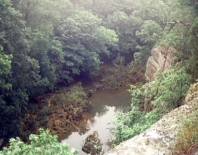
To paddle the whitewater and canyon section of Lusk Creek, there are essentially two options -- neither of them very good: Stone Bottom Road (west) or New Liberty Church Road/ Hwy 10 (east). On the official Delorme Illinois Atlas/Gazetteer (p. 90) Stone Bottom Rd is labeled 'FR 1628' and shows the solid-line road peter to an intermittent dash to the water, where there's an official 'hand-carry boat launch site' symbol. Whether that's 100% accurate I can't verify, because the 'road' was a rough sloggy hash of liquified mud that was too washed-out and rutted for my Subaru Outback to even consider without getting stuck and stranded. (True, this was in late March, after a rough winter but before the road crews got out to improve things. That said, Lusk Creek is paddleable only after some solid rain, which will render the roads mud-slop regardless.) To avoid a serious pain-in-the-pass 'portage' via forest trails just to put in on the creek, you'd need a 4WD truck. We had no such option, so instead we parked at the trailhead for 481/ Saltpeter Cave/ Natural Bridge and schlepped/hiked 1.5 miles to the water (which sucked, but was worth it).
As for New Liberty Church Road/ Hwy 10 (which in the atlas/gazetteer goes first by FR 404 then FR 488 and finally 1000 E), I personally can't verify this, as there was no time to scout, but a seemingly well-knowing soul at the visitor center in Harrisburg was confident that one could drive down to the church/cemetery, park there, and then hike in to the creek. To put this in perspective, the satellite map on Google Maps shows that this is feasible, in theory, but none too promising. There is no official trail here, so even though the shortest distance between the two points of the road and water is approximately 0.6 mile, that's as the crow flies. On the other hand, there is an official trail (492 A) off of the road -- before the church/cemetery -- and this can be taken down to trail 457, which eventually leads to the creek, but this is definitely a longer hike than trail 481 mentioned above. Furthermore, getting to this spot in the first place more than doubles the shuttling distance. Therefore, the advantage of putting in over here is lost on me. (That said, this was my first time down here and I would be happy to be wrong about all of this if it means a better, more practical way to paddle Lusk Creek!)
Finally, there is a third option (again, in theory) hitherto unmentioned: putting in at the Little Lusk Trail Lodge, a private campground on the banks of Lusk Creek before it enters the national forest. This would be the easiest option of all, by far, but (a) it probably would require permission first to do so (which may not be granted, being Illinois and all), and possibly a fee (again, being Illinois), (b) it would add 3.5 miles of who-knows-what-kind-of paddling before the good stuff at either of the two put-in options detailed above, and (c) it would be really shallow here.
It should be noted that the take-out for this trip is at Ragan Road, which is yet another dirt/mud undeveloped road, off of Eddyville Blacktop Road, 2.6 miles long. It's an easy access for getting off the creek, as it's a ford, so it's shallow and the banks are flat. (There used to be a bridge here a long time ago.) But getting to that spot from the main road won't be easy -- or even doable -- for many vehicles.
Furthermore, it's only another 3.8 paddling miles from the Ragan Road access to the bridge at Eddyville Blacktop Road. While not as spectacular as the canyon and Indian Kitchen sections upstream -- and, really, how many places are? -- this segment of Lusk Creek is totally beautiful nonetheless and does offer a half-dozen Class I-II spots. Taking out at the attractive truss bridge at Eddyville Blacktop Road is pretty easy, too -- downstream side, river-left. There's a large parking area located here, accessible by any vehicle.
Also worth noting, an official canoe launch will be built in the near future, as eagerly boasted by the staff at the visitor center in Harrisburg.
This may sound redundant or already known knowledge, but never get in that creek if there is a chance for rain!! Me and some buddies did it. It rose to over 4000, and frankly we are lucky to have gotten out of there with our lives!We thought we were going to meet our maker at a couple different points. We'd heard people say to not try it if it gets that high, but we decided to any way. Stay Away in those conditions!
I've paddled it several times at both low and higher flows. Beautiful spot, but be forewarned, there are really bad strainers formed by wood at most bends in the river. Lot's of wood piles near all the rapids. I am talking about Lusk Creek. Don't know Bear Creek. Freddie
No articles