Etowah
3 - Highway 9 to Castleberry Bridge. Etowah Falls Section. (Etowah Falls)
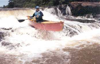
POST FLOOD: Ran the river from Hwy 9 to Castleberry Bridge, Tues 9-22-09 @ 2 pm. Level on the gauge at Buckhorn Tavern was 5.7 ft. There is a large pine tree fallen across the river, less than 1/2 mile from the put in. After the put in the river turns west and meanders behind the Pine Valley Rec Area. The tree is near the end of the rec area as the river turns briefly north. The tree completely crosses the river. We floated over it at 5.7 ft, but it will be a problem as the river returns to normal level (anything below 5 ft). Note at this level, Portage Rock located at Etowah Falls, river right, is almost non-existent. There was also some pretty impressive holes which had developed at both the upper and lower drops at this level along with a very impressive rooster tail at the center of the falls (right where the big rocks are at normal levels). Lower part of this section had alot of fun waves. Took a bunch of pictures to post, but lost the camera just below the falls (it's a blue Canon, reward if found).
No articles