Presque Isle

B) Underwood Tower Rd to Steigers Bridge (7.5 miles)

DifficultyII-IV
Length7.5 mi
Avg Gradient20 fpm
GaugePresque Isle River Near Connorville, Mi
Flow Rate as of 36 minutes
5.94 ftbelow recommended
Reach Info Last UpdatedMarch 3, 2022

River Description

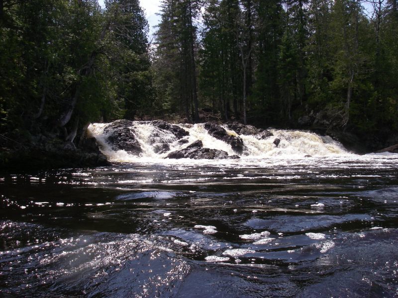
Reach includes Minnewawa Falls and Nimikon Falls.

Some fine video of this run is available at: https://youtu.be/nk85E9flJEM

Put-in: broken bridge on Underwood Tower Road

Take-out: Steigers Bridge on logging road

Note: Getting shuttle vehicles down to the listed take-out at Steigers Bridge may not be available due to the logging road being closed (gated). This may necessitate continuing downstream to run the Lower Presque. This makes a long day, paddling a total of 15.7 miles (or 16.8 to the mouth, including the 'final mile' or Bottom Presque run).

Note: There is about 16 miles of low gradient river from the listed take-out of the prior (upper section) to the put-in for this section.

Click here for Part 1 of an article from the AW Journal, way back in 1981!

Click here for Part 2 of the article.

The article describes the following: Michigan's, Upper Presque IsleLower Presque IsleMiddle BlackLower BlackUpper Silver,  Lower Silver

...

River Features

Put In

Distance: 0 mi

Minnewawa Falls

Distance: 3.77 mi
Waterfall / Large Drop
Minnewawa Falls

(Description from Google Satellite view)

It appears a substantial island splits the flow, with the larger channel to the right. Both channels pour into a large pool. A (logging?) road passes through below.

Nimikon Falls

Distance: 4.06 mi
Waterfall / Large Drop
Nimikon Falls

(Info primarily from Google Satellite view)

This is not so much a 'falls' as about a quarter-mile series of ledge drops.

Take Out

Distance: 7.5 mi
Take Out

Bryan Foster
Bryan Foster

Jul 22, 2014


FLAT WATER. Ok, I said it. There is way more flat water here than you might expect for a river with such whitewater fame. Regardless, with the limited access at steiger's bridge, this is the way to see some great whitewater, and get some paddle fitness in.
-------------------------------------------------------------------------------------------------
First things first, the put in is at a 90 degree left bend in Underwood rd/FR481 where a small grass area for parking cars and an ATV trail over a berm is. Do not try the short cut through on the forest road West, you will end up meeting locked gates, instead head back out to Hwy 28.
-------------------------------------------------------------------------------------------------
For the first part there is a bunch of flat water intermingled with rapids. When ever you see an island with substantial gradient that you can't see down, hop out and scout.
-------------------------------------------------------------------------------------------------
The first big rapid is Minnewawa Falls, there is a nice class III- drop just before it which is marked by a rocky island splitting the river. Minnewawa is split by an island as well, with most of the water moving down the right channel. The right channel proceeds thought a constriction of bedrock and then drops a few feet into a fast moving wave/hole followed closely by a second 5ft green tough drop into another wave/hole with a large pool with waves and buggy water directly after the drop. The left channel has a single drop which may offer a few lines at higher levels.
--------------------------------------------------------------------------------------------------
A little more flat water, then another rocky outcropping splits the current. Shortly after this the river gradient picks up the pace with the majority of the water moving down to the right. There are a number of eddies on the right shore to catch to get out and scout Nimikon Falls. This falls has a left line which is a series of wave holes and smaller drops and a right line with a steeper drop into a pool. There is a small fraction of water that takes a left line around the island which might offer another drop to consider a carry up, because there is a lot of flat water after this.
-------------------------------------------------------------------------------------------------
Now for more of the endless flat water, until Steiger's rd bridge. The pace picks up from there, and you are now in the middle section.

Bryan Foster
Bryan Foster

May 18, 2014


(started at 2' on visual gauge at south boundary rd., ended run with 1' on visual gauge at south boundary rd.)