Tuckasegee, West Fork
Thorpe Dam to Thorpe Powerhouse on Tuckasegee Reservoir(WF Tuck)
| Difficulty | III-IV+ |
| Length | 5.6 mi |
| Avg Gradient | 143 fpm |
| Next Release | Sat, July 25, 2026 |
| Reach Info Last Updated | August 1, 2020 |
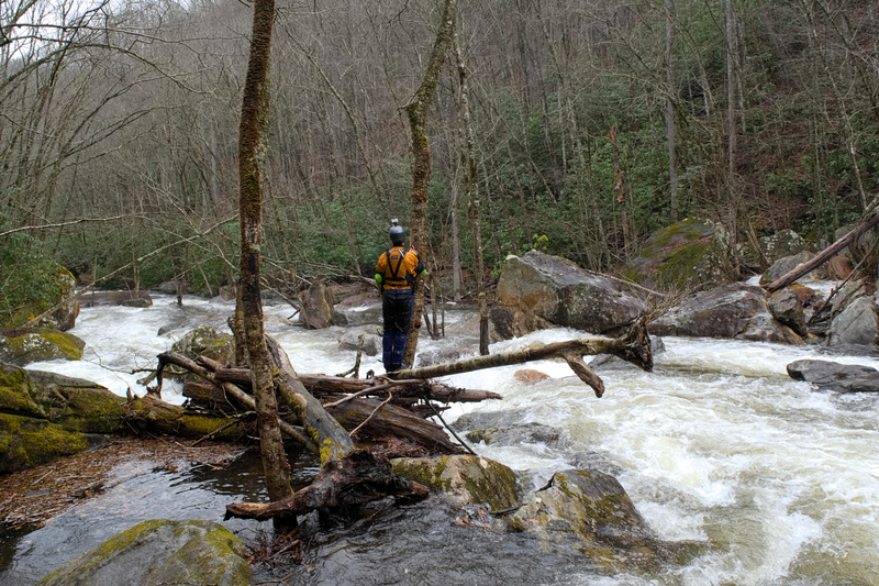
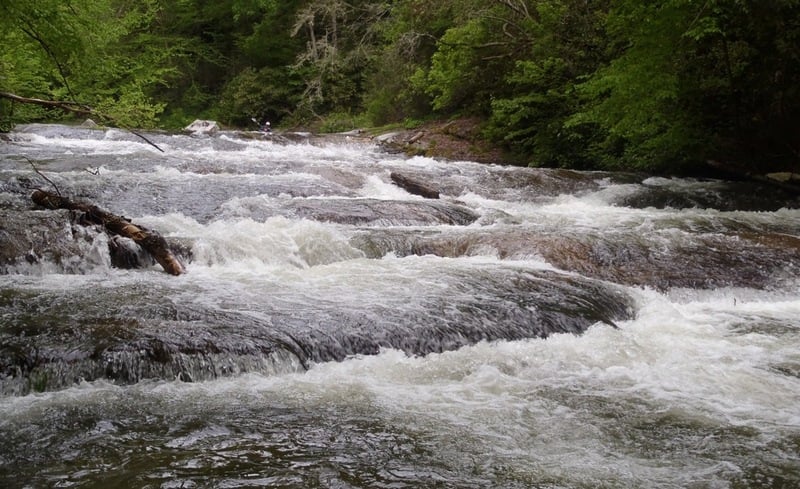
The West Fork Tuckasegee Gorge is currently a wild and beautiful, but woody place. Hike in on the incredible trail built by Duke Energy that starts in a well-signed parking lot just across the dam from Highway 107. You'll hike past a memorial plaque for Charles Paul Horner, whose memorial fund helped American Whitewater to establish and negotiate the trail route. Don't get lured into putting on before the trail ends at the base of the massive double drop known as High Falls or Cullowhee Falls. Put on too soon and you could risk going over one of two big unrunnable drops.
At the put in, amidst the spray and wind coming off High Falls, you will have a choice: Either paddle across the river and hike around the first two challenging Class IV/V rapids, or run them. Note that the entire run below the put in is private property. After the two entry rapids (and some wood) the river mellows and flows through small rapids until a house comes into view on river left, and an obvious horizon line appears. This is the first of three small sloping ledges that lead to the hallmark drop of the run, Breakbone Falls, a 25 foot slide on the left called Crash Landing and a three-tier sloping-then-vertical drop on the right usually called Flight Simulator or Fright Stimulator. The left side is run well left of center. The right side is run only a few feet off the right bank. Note that at least two people have suffered significant back injuries on this slide, and scouting the left side is extremely difficult.
Small rapids (and strainers) continue until you come to two houses on the stream bank on river left. Both homeowners are very concerned about trespassing, so please be respectful. The river bends sharply to the right immediately after passing the houses and offers a nice 4 foot boof a couple feet off the left bank. There is a rock in the landing but a good boof
...
Launching immediately below the dam is not recommended because of the major waterfall, called Onion Falls downstream. In fact access is restricted to this section during a dam release. Fun Fact...the orginal Onion Falls was mostly destroyed when Lake Glenville was being built. What you see now is only a small section of it.
You'll probably see this waterfall on your right as you hike down to the put in.
Mandatory Portage! This waterfall has two tiers and is about 170 to 200 feet high. The river right side is blocked by high cliffs, but there is a use trail on river left which facilitates the portage.
Park here to begin the winding trail down to the base of High Falls. Stay on the trail all the way to the river to avoid launchinc above some huge unrunnable waterfalls. This trail, like the releases, were negotiated by American Whitewater and our partners as part of the hydropower dam relicensing in the early 2000's.
This is the recommended put in because it avoids two very difficult portages. A parking area is located about 0.25 mile after crossing the dam's spillway. The trail to the put-in begins with a gravel road and then becomes a trail with log steps and boulder steps down to a put-in that is sprayed with water comming off High Falls.
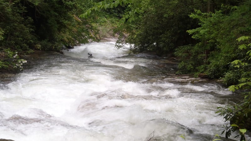
Put in below High Falls. To walk the put-in rapid, ferry across the river to the big eddy and the river right trail. A long class IV rapid begins immediately after the put-in. At levels higher than the normal release, the two rapids merge into one.
A small pool on river-right separates the put-in rapid from the first boulder garden. This second rapid is roughly 100 yards long. The first half can be run river-left or center. The last half is run river-right. One should scout river-left before putting on if running the left line because trees tend to accumulate a few feet downstream of the first drop. Trees also accumulate in the center line, but they're usually obvious from the upstream pool.
A shallow, slight, low-angle slide and perhaps 30 yards of class II+ water separates the first boulder garden from the second boulder garden. The river splits into two channels 10 yards or so downstream of the surfable reciruclation at the based of the slight, low-angle slide. Take the right channel and prepare to either boof left off a 5ish foot boulder jam (visible in the photo above). If you get pushed into the boulder jam before making the left boof, you'll probably be fine. The boulders pool the water enough to stay fairly stable while getting your boat aligned to make your way over the left boof. The drop is immediately followed by 20 yards of a fast, bedrock rapid (not visible in the photo). Be aware that there are two sieves in the boulder jam and that some water flows into an ugly (potentially vergy ugly) slot right of the boulder jam.

A little over a mile of class II water along with two or three class III rapids follow the second boulder garden. The first class III rapid after the second boulder garden passes a pretty waterfall on river-left formed by Rough Run Creek. It is private property and posted as such with signs and steel cables.
A trail on river-right is never far from the river until the river-right bank steepens and rises 50 feet or so above the river. The trail is on private land, but public access by foot is generously permitted with posted restrictions (no fires, no camping, no hunting, etc.). Signs near the trailhead on Shoal Creek Mountain Road specify the restricted activites.
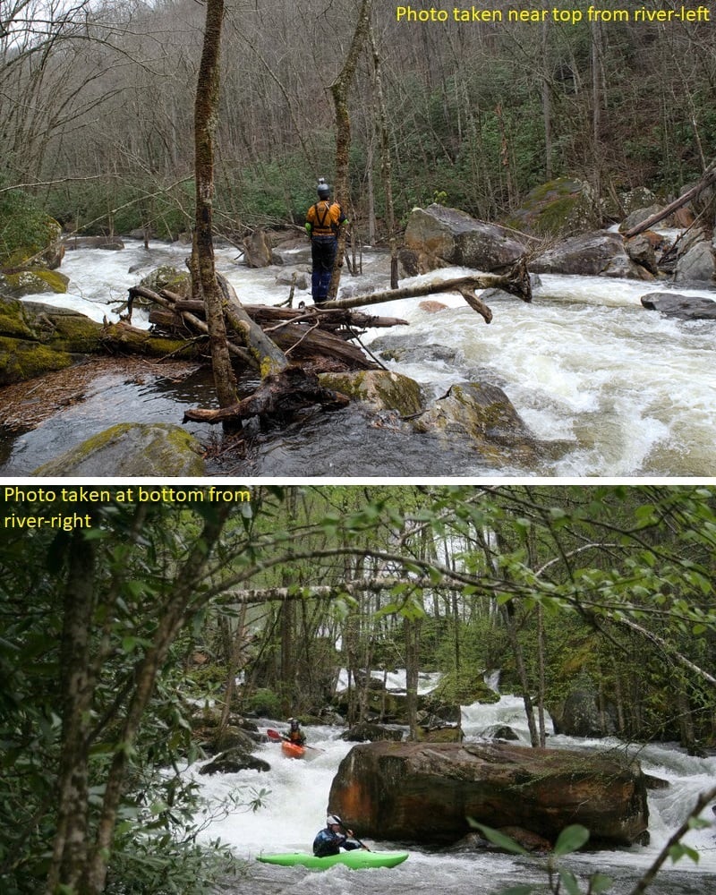
The first horizon-line you see about the time a house comes into view on river-left is *not* Breakbone Falls (aka, Flight Simulator). It's a 10ish foot high ledge on river-left or a fun, fast curving slide on river-right. You can see the horizon of Breakbone about 100 yards downstream from the base of this first lead-in ledge. There are two more sloping ledges upstream of the falls. Both have eddies in the center, left, and right.
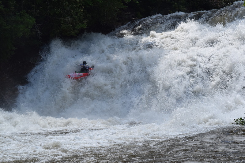
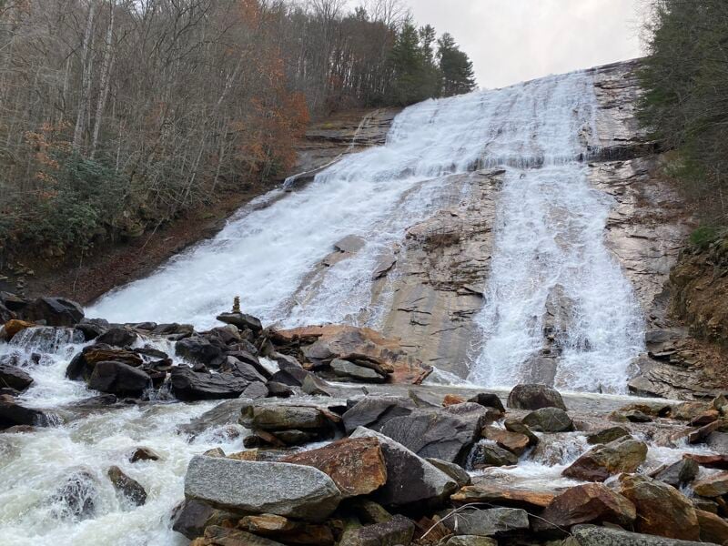
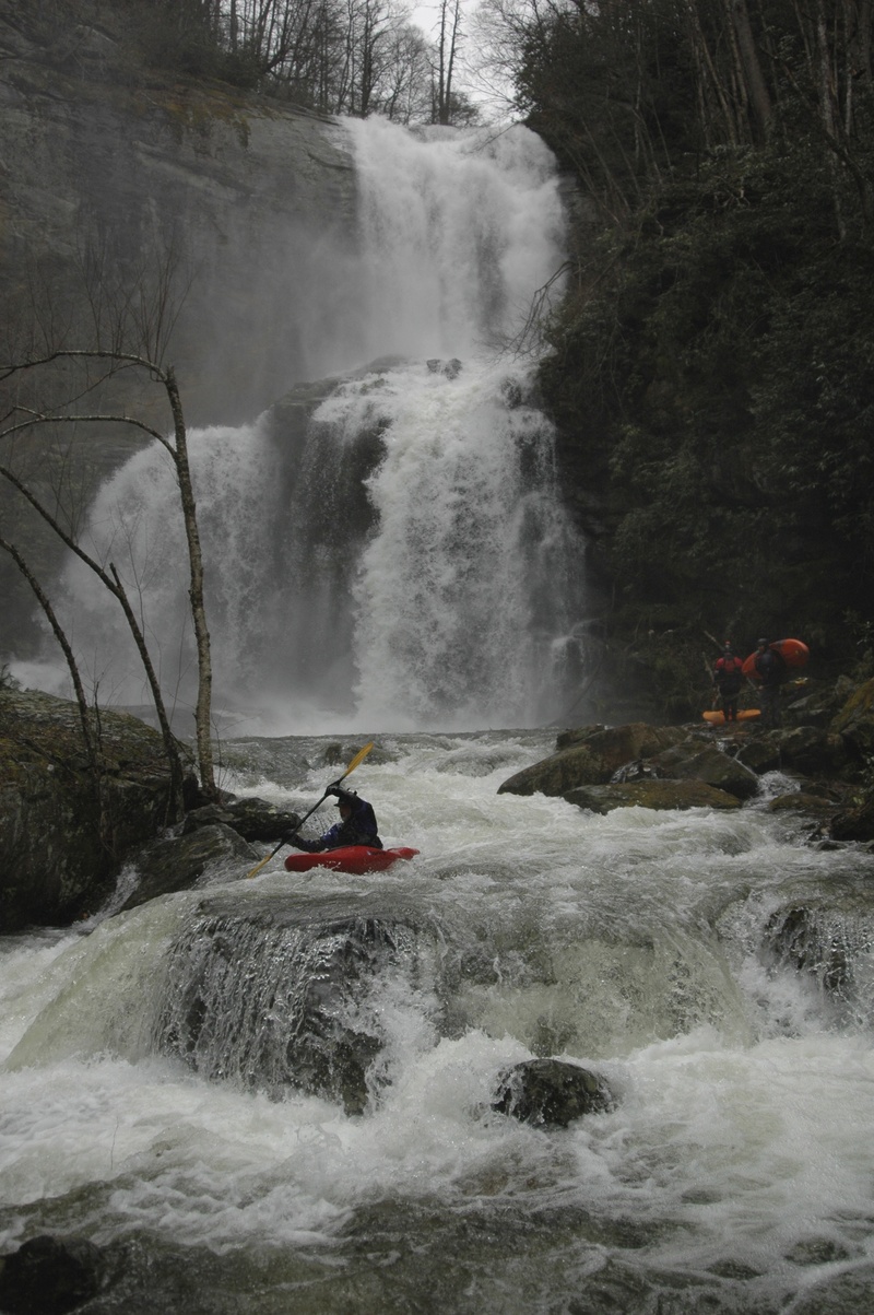
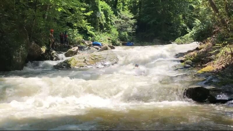
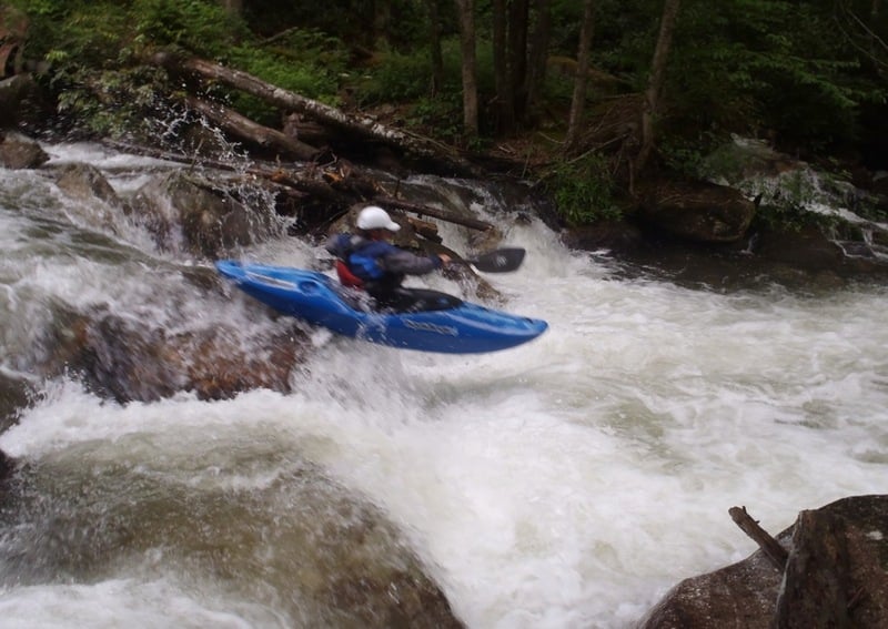
Leland Davis, the first known to run the right line, informally called this falls 'the Big One' in his guide to western NC creeks and rivers. The river's local sage, Burt Kornegay, says it's 'rough as a cob' and has long called it Breakbone Falls, an apt name given the fact that it fractured vertebrae of two people who were carried out on backboards during the first year of official releases. See http://www.americanwhitewater.org/content/Article/view/articleid/31911 for identification of the line where injuries have occurred.
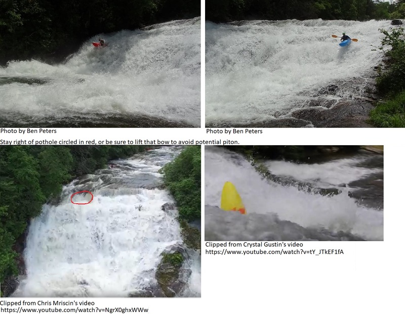
The river-right line (commonly called Flight Simulator, but also called Fright Stimulator or Go Right and Fly) is about 25 feet high. It starts with a 6.5 foot sloping ledge if you're far enough right, but it'll start with a pothole that's 7 feet deep and 12 feet wide if you're too far left. The sloping ledge ends with a 4.5 foot drop followed by a 14 foot vertical drop. Beware pitoning at the top or at the bottom if too far left. Pitoning in the top pothole can result in a beating, either in the pothole or on the way down the remaining 20ish feet. Harrison Metzger, who likely made the first open boat run of the right line, recommends 'being 7 to 8 feet off the right bank with a slight left angle, which should deposit you in the 'fluffy box of bunnies' froth below.'
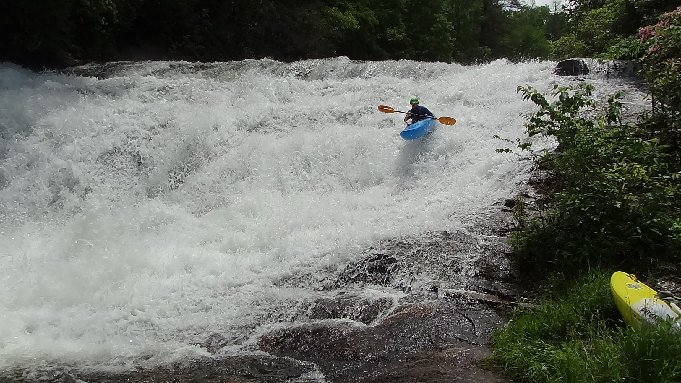
The river-left line (known to some as Crash Landing) is a 28 foot, broken, rough slide into a large pool. Enter far left over the center of a small wave on the horizon line. Being too far right on the small wave results in a ride with two or three very hard hits. Being too far left can result in hitting a bedrock slab about one-third of the way down.
Thanks, Burt Kornegay and Harrison Metzger, for making the measurements.
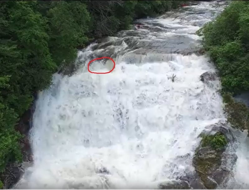
One more word about back injuries. The big bounce on the river-left line that has caused back injuries is located near the bottom a bit right of the ideal left line. Photo 1 and photo 2 show boats on the big bounce. Paddlers who lean forward over the bounce have had far smoother lines than those sitting up or boofing. Check out this photo taken at base flow to understand the landing zone.
A few class II+/III slides and ledges form the runout of Breakbone Falls and lead to a right bend that is soon followed by three houses and a stretch of class II bouldery water. The river bends right again after this stretch and offers a 3 to 5 foot river-left boof in the bend. Several class II+ ledges and a couple class III ledges (some bouldery, others bedrock) and small slides follow.
Shortly after passing a house on river-right, there'll be a horizon line that marks this 20ish foot, medium-angle cascade. Run it pretty much anywhere, but most run it center and just a smidge left of center for the most fun. Do not get too far left or you may dry out on your way down. There is a medium-small hole midway down the center-left line. There are two medium-small holes near the bottom of the center line. There's a ledge hole at the bottom of both lines, but it has been friendly at the normal release level. A medium size sloping ledge with a moderately stronge hole on river-left and then some fun slides follow Kornegay's Cascade for about 0.1 mile.
This cascade is visible from the guard rail of the hairpin curve on Hwy 107 known as Cabbage Curve. However, the property along side the road is private and posted.
After going under Cullowhee Forest Bridge, head right over wet bedrock. Stay right to boof the left side of a 5 foot ledge. Alternatively, head over to the left bank for a steep 10ish foot slide that hides between the bank and a large boulder.
The next rapid is 30 yards or less away. It's a sloping ledge that has a left-to-right crease in the bedrock. Some run right to left. Others run it pointing straight downstream.
The photo above shows the third rapid after the bridge. This shallow slide can be run about anywhere. The photo was taken when the level was much lower than the normal release level. The ledges visible in the photo are padded to the point of being pretty much indistinguishable during a scheduled release, but the slide is still shallow.
A left bend after the slide signals the lead-in to the mini gorge.
People who participated in the 2001 flow study identified a collection of four rapids as the 'mini-gorge.' The number of back-enders and flips they experienced in the first rapid of the mini-gorge led them to collectively name the rapid High Turnover. This first rapid, which is also called The Crux and Burt's Beasts by some people, is indeed 'the crux' of the mini-gorge. It is distinct from the mini-gorge's other three rapids, and it is separated from them by a pool and another 50 yards or so of class II water: The rapids downstream of High Turnover include two back-to-back (but distinct) ledges followed by a long, tight, fast, bedrock rapid with small ledges and strong swirls. These three rapids become one, long rapid when the level rises above 3 feet on the gauge at the take-out bridge Each is identified separately with individual descirptions for clarity.
The mini gorge's High Turnover can be scouted river-right.
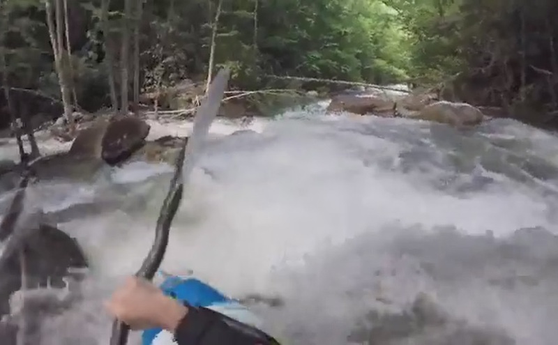
Photo shows the first half of High Turnover, which consists of a steep, sloping ledge with a flushy hydraulic that feeds into a sneaky, speed-trap hole followed by a benign-looking ledge that drops 2 to 3 feet. Much of the water at the top of the first ledge pushes left. Running it left or running it center without driving right is exciting, but often puts even large boats in line to be grabbed by the speed-trap hole. Here's a video that shows what the speed-trap can do to even skilled boaters. A slower line is to ferry high above the drop, turn, and run the ledge a smidge right-of- center, pointing straight or with the slightest of right angle and planning to avoid the speed-trap hole by timing a stroke near the bottom to drive right and over the boil, or by planning to catch the right eddy at the bottom of the ledge. The speed-trap isn't so bad by itself. The problem is it can cause a person to drop over the second ledge at a bad angle. The hole at this second ledge is sticky on river-left, but most people are able to work themselves out on river-right (surfer's left).
The second half of High Turnover is a gently sloping bedrock slide 10 to 15 yards long, leading to a hole and pool. But the slide looks more like a third ledge because the river placed two large, mostly submerged boulders halfway between the second ledge and the pool in 2016. People typically run a tongue between the two boulders left-of-center or they boof the right side of the center boulder. The hole at the end of the shallow slide has a strong, horizontal recirculation coming off the river-left, bowl-shaped wall. The hole is strongest on river-left. You'll probably glide over the hole if the level is normal, if you're pointing downstream, and if you put in a stroke or two at the hole. If stuck, work your way out on river-right (surfer's left). Flipping often flushes people in their boats out of the hole.
A pool follows High Turnover. The river splits 50 feet downstream of the pool. The left channel is usually blocked with wood. The river-right channel is shallow and cluttered with suitcase-size rocks that want to force you farther right, which is bad. Regardless of which channel you take, get to the center as you round the island because you want to hit the center launch pad of the ledge that follows. There is real potential for a vertical pin in the right corner of this ledge.
The photo was taken when flow was WAY LOWER than the normal release level.
Be aware that the this ledge changes its nature when level exceeds 3ft on the gauge at the take-out bridge. The center pad becomes a pour-over into a very large, boiling, recirculating hole.
Typically run far right. At normal release levels, there are two river-right eddies and a river-left eddy between Center Boof and Crevice Ledge. Some people run it exactly as shown in the photo, boofing into the crevice. Others run far right. One an also run it far, far left (shoulder agains bank). Running it left or center is abusive.
The photo shows that the mini-gorge's 3rd rapid and its 4th rapid can be considered a single, long rapid even at 2.6ft. They truly merge into one long rapid when the level nears or exceeds 3ft.
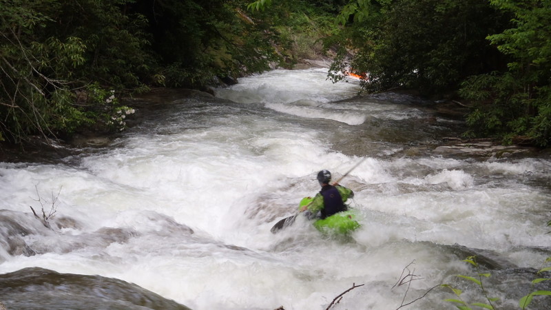
Coming off Crevice Ledge river-right or center-right will feed directly into this last rapid of the mini gorge. A tongue of fast green water sweeps down right-to-left before rising and piling up on the river-left wall. The water then swirls for a couple hundred feet over smooth, gneiss bedrock with three small (~3ft) ledges under a smooth-face cliff. The swirling water, fun waves, smooth bedrock, and sheer cliff create the sense of being in a miniature, less difficult version of Tallulah's Amphitheater. Although usually pure fun, you should be watching for wood in this very narrow, fast, swirling stretch.
Photo shows paddler dropping into the top of this fourth and last rapid of the mini gorge.
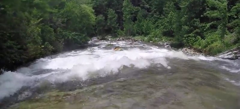
A mix of class II and III water. There are three class III right bends, several class II to III wave-trains and shallow, low-angle slides...and usually new trees.
The take-out is across Hwy 107 from Thorpe Powerhouse on the downstream, river-right side of a metal bridge. It is clearly identified with a sign as the take-out. The official stick gauge is located on river-right under the bridge, bolted to a boulder near the bridge's foundation. For release weekends, expect designated parking areas for paddlers.
Jul 27, 2020
Please edit the main river description to reflect the fact that very few people now run the left side (Crash Landing) of the big drop for the reasons noted in the description. Flight Simulator is typically run about a boat length off the right bank with a slight left angle for best results.
Jun 10, 2017
Pothole to avoid at top, right of Breakbone Falls (aka, Flight Simulator). Clipped from Chris Mriscin's video (https://www.youtube.com/watch?v=NgrX0ghxWWw)